
Written by Sig Silber
U.S. and World Agriculture: Plus an Expanded Weather Forecast Section
Updated at 3:30 p.m. EDT May 31, 2019 to reflect both the updated Week 3 – 4 Forecast and the New June Drought Forecast Map both of which continue the same situation which is Southern Plains too wet and the Northwest and a larger area in the Southeast too dry.
A stagnant pattern resulted in severe storms and flooding in the Central and Southern Plains and also the Midwest. The forecast is for more of the same pattern but less amplified and perhaps moving slightly east and south which might impact the Lower Mississippi River. But west and east of the heavy rains it was normal to dry so we have seen mild drought redeveloping in the Southeast. This probably will be reduced if the weather develops as currently forecast. The crop progress reports again range from bad to very bad. The recent weather has not been helpful.

Please share this article – Go to the very top of the page, right-hand side, for social media buttons.
It is important to understand that the impact of weather on economic activity varies from one place to another. In this article, we try to provide a broad view of the impacts focusing mostly on the U.S. but also to a lesser extent on the Rest of the World. |
Major Sources of Information Used in this Weekly Report
|
1. Special Reports and Highlights.
New Report:
Flash Drought: Lessons Learned from the 2017 Drought Across the U.S. Northern Plains and Canadian Prairies.
Jencso, K., B. Parker, M. Downey, T. Hadwen, A. Howell, J. Rattling Leaf, L. Edwards, and A. Akyuz, D. Kluck, D. Peck, M. Rath, M. Syner, N. Umphlett, H. Wilmer, V. Barnes, D. Clabo, B. Fuchs, M. He, S. Johnson, J. Kimball, D. Longknife, D. Martin, N. Nickerson, J. Sage and T. Fransen. 2019. NOAA National Integrated Drought Information System. Click here to read.
We will discuss this and other related reports in more detail over the weeks ahead but tonight we will present the timeline.


Severe Weather


| Last Week | Current Week |
|
|

Looking Ahead re Agriculture Field Work
| Last Week | This Week |
|  |

2. Summary of Intermediate-Term Weather Forecast (helpful to predict drought and floods etc)
Here is the summary of the forecast for the next approximately twenty-five days. We provide this so that we can make our own assessment of the drought forecast. Here I provide the weather forecasts for different periods of time in which should allow the reader to assess the likelihood of this forecast working out as shown over the next three to four weeks. Since we publish this week on Thursday, we generally update the discussion for the Week 3 – 4 forecast when it is updated on Friday. This is important as the current Day 6 – 14 forecasts and the week-old week 3 – 4 forecast overlap to some extent.
Later we provide additional information relative to the weather forecast analysis but here is the summary.
First Temperature
|
|
|
|
The graphic above shows magnitude rather than the probability of being higher or lower than Normal and shows the middle day of the five day period. | That is a big change from Week – 1 to Week – 2. The transition from the 8 – 14 day forecast shown above to the week 3/4 forecast seems feasible. The week 3-4 graphic was updated on May 31, 2019 | ||


And then Precipitation
|
|
| |
The five-day QPF is shown above. The units are different than the other maps i.e. in units of precipitation (inches) not probabilities of exceeding or being less than climatology. | Fairly stagnant. This forecast if realized should benefit the Southeast and even the Northwest. But the flooding potential in the Center remains but it may be shifting a bit east and south. The transition from the 8 -14 day forecast shown above to the week 3/4 forecast does not seem likely for the Southeast and perhaps not for the Northwest either. The week 3-4 graphic was updated on May 31, 2019 | ||


Here is the updated discussion released on May 31, 2019
Prognostic Discussion for Week 3-4 Temperature and Experimental Precipitation Outlooks NWS Climate Prediction Center College Park MD 300PM EDT Fri May 31 2019
Week 3-4 Forecast Discussion Valid Sat Jun 15 2019-Fri Jun 28 2019
Most of the sea surface temperatures throughout the equatorial Pacific are above normal, coincident with a weak El Nino pattern. A moderate MJO is located in Phase 2 over the western Indian Ocean. Forecast models seem to be in agreement that the MJO will continue into Phase 3, but interfering Rossby and Kelvin wave activity causes the models to collapse the MJO before it gets to the Maritime Continent. Regardless of whether the models are correct about the MJO’s collapse, we expect that the general circulation is too weak to be forced by MJO or ENSO convection.
The forecast is based primarily on our calibrated dynamical model guidance (blends of the CFS, ECMWF, and JMA) as well as the SubX model suite. The forecast leans towards the ECMWF over regions where the models disagree most. Dynamical models broadly agree that weak to moderate ridging will persist over Alaska during Weeks 3-4. The CFS brings the ridging into the western CONUS whereas the ECMWF and JMA keep the ridging north of the U.S. border. The SubX multimodel ensemble (MME) mean is most similar to the ECMWF solution.
The temperature forecasts are also broadly consistent among the various models with anomalously warm temperatures forecast for Alaska and the Northwest CONUS and anomalously cold temperatures forecast over the southern Plains and Mississippi Valley. The ECMWF and JMA predict probabilities of anomalous cold throughout the interior Northeast of around 50-60%. The ECMWF has over 70% probabilities of anomalous cold along coastal New England. Interestingly, the SubX MME probabilities through the Northeast are closer to 50% (equal chances) than any of our calibrated models. The models also hint at above normal temperatures throughout parts of the Southeast and our statistical tools favor above normal temperatures over southern Arizona. Putting this all together, our temperature forecast features above normal temperatures throughout the Northwestern U.S., southern Arizona, Florida, and southern Georgia and Alabama. Below normal temperatures are forecast over the southern Plains, Northeast, and Mid-Atlantic regions.
Model agreement about the precipitation forecast is similar to the temperature forecast. The ECMWF forecasts calibrated probabilities of below normal precipitation of 55-70% over most of the eastern CONUS, with the strongest probabilities located over eastern Tennessee. However, the CFS and JMA have wetter solutions across the Southeast and New England. The SubX MME solution is most similar to the ECMWF. Elsewhere, there is broad agreement of below normal precipitation in the Pacific Northwest and Alaska as well as above normal precipitation over the Southern Plains. The final forecast leans towards the ECMWF and SubX solutions over the Northeast, with 50-55% probabilities of below normal precipitation.
Above normal SSTs and dynamical model consensus suggest that Hawaii will have above normal temperatures during the Week 3-4 period. There is also a model consensus of above normal precipitation, with the strongest probabilities over the southeastern islands.

Additional Information on the forecast is provided later.
3. Present Drought Conditions
The U.S. Drought Monitor is a comprehensive way of understanding the drought situation for the U.S. It is issued every Thursday and reflects the conditions as of the prior Tuesday. Drought is defined as a moisture deficit bad enough to have social, environmental or economic effects. Thus, more factors than recent precipitation are considered and more information on how it is done is found at the end of this report.

Something relatively new and concerns an area that is in drought probably due to the El Nino. This part of the world generally requires two inches of rain per week to avoid drought. You can see that about 8N is the dividing line between Moderate to no Drought and Severe to Exceptional Drought.

Below is the map for just CONUS and with statistics and below that map I have provided a cut-out of the statistics which I think you can click on to enlarge. When you click on graphics that I have set up to enlarge often with your mouse right click and then click on “view image” and that will work.
 |
 |
| Last Week | This Week |
| |

The graphic below shows the one-week change in drought intensity. Yellow is bad. Green is good.
|

Now we show the week to week change information by region. The yellow is where the drought has been upgraded. The green is where the level of drought has been downgraded.
 |
Improvement in Wyoming and Nebraska |
 |
| Some deterioration in Kentucky which such believe is part of the Southeast |
 |
| No Change |
 |
Some deterioration in Texas and also Tennessee which some may consider to be part of the Southeast. |
 |
| Deterioration in all the Southeast states |
 |
Minor deterioration along the Northern Tier in Eastern Washington State, Idaho and Montana with improvement further south in Washington State and Wyoming. |
Some may find this way of looking at things useful and I hope these graphics are not too small to read. I did not make them so you could click on them individually but you can click on the whole graphic and it may enlarge. But I think you get the picture. It has been a rapid onset and demise. When you read these graphics, remember that the older graphics are not the drought conditions that existed then but the change from then until now.

Some might find this animation of twelve weeks of change useful;

Here is the discussion which was issued with the Drought Monitor today.
This Week’s Drought Summary
During this U.S. Drought Monitor (USDM) week, a strong high pressure ridge was anchored over the southeastern contiguous U.S. (CONUS) while an upper-level trough dominated the West. This pattern set up a southwesterly flow across the central part of the country, which funneled moist and unstable air from the Gulf of Mexico into the Plains. Pacific weather systems moving in the jet stream flow plunged into the western trough, bringing precipitation and cooler-than-normal temperatures to much of the country from the Rockies westward. The weather systems intensified as they moved into the Plains, triggering another week of severe weather and heavy flooding rains. Two or more inches of precipitation occurred across the Plains to Midwest and in upslope areas of Montana and Wyoming, with locally 5 inches or more. Weekly precipitation was wetter than normal across much of the Southwest, and from much of the Great Plains to Great Lakes. Half an inch to locally 2 inches was observed from the central Appalachians to New England, but these amounts were mostly below normal. The week ended up drier than normal across western Washington, northern Idaho and northern Montana, southern Arizona, most of New Mexico, and central to southern Texas. The subtropical high kept the Southeast drier and warmer than normal, with record high temperatures reported. As a result of this weather pattern, drought contracted in Oregon, Wyoming, and the central Plains, but expanded in the northern Rockies, Texas, the Tennessee Valley, and the Southeast.
Northeast
This week was drier than normal for much of the Northeast, with dry areas developing over the last 3 months. Pockets in New England were nearing a 3-inch precipitation deficit over the last 90 days. While the region is currently free of drought or abnormal dryness on the USDM map, D0 could be added in the coming weeks if below-normal precipitation persists.
Southeast
The subtropical ridge left most of the Southeast with no rainfall this week and several record maximum temperatures. The hot weather increased evaporation and dried soils. Only isolated areas, mostly in the Carolinas and Florida, had any rain at all and amounts were mostly less than half an inch. D0-D1 expanded from northern Florida to southern Virginia. Dry and hot conditions prevailed for the last 2 to 4 weeks, with below-normal precipitation noted in many areas for the last 3 months. Some of the drought indicators, especially the Standardized Precipitation Index (SPI), Evaporative Drought Demand Index (EDDI), and soil moisture indices, indicated D2 was imminent, but D2 was not added this week. May 26 U.S. Department of Agriculture (USDA) reports indicated that 77% of the topsoil moisture in Georgia was short or very short (dry or very dry), up from 41% last week. Other states had similar increases: Alabama increased from 12% to 47%, Florida increased from 42% to 64%, North Carolina increased from 29% to 60%, South Carolina increased from 48% to 86%, and Virginia increased from 3% to 26%. Subsoil moisture conditions were just as bad, with short to very short subsoil up to 33% of Alabama, 52% of Florida, 55% of Georgia, 14% of Mississippi, 50% of North Carolina, and 76% of South Carolina. According to media reports, Brunswick County in southeastern North Carolina issued a notice to “use water wisely” due to developing drought conditions and increased demand, and was considering instituting water conservation measures. Nearby Pender County restricted water use due to an ongoing water shortage emergency in southeastern parts of the county caused by high demand, hot weather, and limits in their distribution system. In Georgia, reports from Coffee County included hay reserves disappearing, soils drying, and heat stress to crops; planting stopped on non-irrigated acres and irrigation was turned on for irrigated acres.
South
Precipitation amounts in the South ranged from zero in parts of Texas, Louisiana, Mississippi, and Tennessee, to over 5 inches in northern Oklahoma. D0 expanded in central Tennessee where 90-day precipitation deficits were noteworthy, pockets of D0 expanded or were introduced in southern Texas along the Rio Grande or along the coast, and D1 was added to Zavala County in Texas where dryness was evident for the last 7 days to 6 months. According to USDA reports, 21% of the topsoil moisture in Tennessee was short or very short, up from 3% last week. The last couple weeks have been very dry, hot, and windy in southern Texas as the subtropical ridge continued to build and dry out the atmosphere. There have been reports of significant evaporation of Cameron County retention ponds with fields and lawns showing some browning. Some producers in Dimmit County, Texas were hauling water and supplemental feeding in some areas.
Midwest
Precipitation this week in the Midwest ranged from widespread 2+ inches in the western portions to less than an inch in the eastern portions and a tenth of an inch or less along southern Kentucky. D0 expanded into Kentucky from Tennessee where 7-90 day precipitation deficits were significant, and a small area of D0 continued in northwest Minnesota. Otherwise, the Midwest region was devoid of drought or abnormal dryness. According to the USDA, short to very short topsoil moisture grew from 3% of Kentucky last week to 15% this week.
High Plains
The central to northern Plains received 2 or more inches of precipitation across a large area from Kansas to Wyoming and southern Montana, with 5 or more inches measured in Kansas and Nebraska. An inch to 2 inches occurred to the north and in parts of Wyoming, with less than a half inch measured in southwest Wyoming and northwest North Dakota to north central Montana. The precipitation deleted D0 in southwest Nebraska and D1 in the Big Horn Mountains of Wyoming and shrank the surrounding D0. But D0 expanded across the northwest corner of North Dakota into northeast Montana where 90-day precipitation deficits were notable. Windy conditions and sparse rain have dried soils in Daniels and Sheridan Counties in Montana, with fire risk increasing. Soils were drying in northern North Dakota and some sloughs and ponds had low water levels. An inch or more of rain this week prevented the expansion of D0 and addition of D1 in northern North Dakota this week, but it may be considered for next week.
West
D0-D1 remained in parts of Arizona and New Mexico, and D0 remained in southern California, both reflecting long-term dryness which has built up over the last 5 to 6 years (and low reservoirs in southern California), and in Washington to northwest Oregon. Precipitation was above normal in southeast Oregon at most time scales, so the D0 there was deleted. But in western Washington to northwest Oregon, this week was dry and most of the last 1 to 2 years have been drier than normal, mountain snowpack was diminished from normal values for this time of year, and streamflow was much below normal to record low. D0-D1 here reflected these conditions for now, but D2 may be needed if conditions worsen. D0-D1 expanded in the Rockies of northeast Oregon, far northern Idaho, and northwest Montana where streamflow and precipitation and SPI values for the last 4 months were low.
Alaska, Hawaii, and Puerto Rico
In Alaska, the panhandle continued much drier than normal this week with the rest of the state having a mixed precipitation anomaly pattern, while temperatures were warmer than normal for most of the state. The USDM status remained unchanged for Alaska, with D0-D3 continuing in the panhandle.
Record warm maximum temperatures continued this week in Hawaii, with below-normal precipitation occurring at most of the stations. A small portion of the Big Island down near South Point continued to deteriorate. Ranchers reported little to no feed from their pastures. FSA reported around 90% loss of grass and one rancher indicated he’s starting to sell off some of his herd. Pastures along the Hamakua slopes have been deteriorating. On Maui, the Department of Water Supply declared a Stage 1 water shortage for Upcountry Maui. On Oahu, the west side has been very dry, with the FSA reporting that their customers no longer have ranching operations in the area, and brush fire incidents were also on the rise recently in the west half of the island. As a result, D3 was added and D0-D2 expanded on the Big Island; D1-D2 expanded on Maui; D0 expanded on Molokai; D2 added to Oahu; and D0-D1 expanded on Kauai. Near normal rainfall occurred within the Kona Coffee Belt in the South Kona District, so D0-D1 contracted on the west side of the Big Island.
In Puerto Rico, it was wetter than normal in the northwest and southeast parts of the island and along most of the north coast, but drier than normal across the rest of the island and on Vieques Island. Four to more than 7 inches of rain fell on parts of the northwest, with mudslides and river flooding reported. But soils continued to dry out along parts of the southern coast to east-central interior regions. D0 was deleted from the northwest coast and interior D0-D1 were trimmed along their west and north edges. In the southwest, the northern edge of D0 was trimmed, but D1 expanded along the southwest coast.
Pacific Islands
The weather pattern during this USDM week (5/22/19-5/28/19) consisted of weak disturbances over central and eastern parts of the Federated States of Micronesia (FSM) with a surface trough from near the Marianas to the eastern FSM, and trade-wind convergence across southern parts of the Marshall Islands (RMI) and eastern parts of the FSM. Other surface troughs appeared then faded over various parts of Micronesia at different times, while a stationary front with upper-level trough hovered just west of the USAPI, and island convection from daytime heating generated rain over parts of the Marianas. A dry trade-wind regime maintained its grip where the convection and convergence were absent. Dry mid- and upper-level air dominated the Samoan Islands for much of the week. Satellite-based estimates of 7-day precipitation (QPE) showed areas of 1-4 inches of precipitation associated with the frontal system and trough along the northwestern edge of Micronesia, across the southeastern FSM and southern RMI associated with the disturbances and trade-wind convergence, and a few areas in northern Micronesia associated with transient troughs. Other parts of Micronesia had little to no precipitation indicated on the QPE. South of the equator, 2-4 inches of rain was indicated east and southeast of American Samoa, with areas of 1-2 inches just north of the Samoan Island chain, and little to no rainfall to the southwest.
Saipan and Rota, which are two of the three stations analyzed in the Mariana Islands, had precipitation totals that were less than half their weekly minimum of 1 inch at 0.23 and 0.20 inches, respectively. Meanwhile, Guam had wet conditions for the first time in at least 11 consecutive weeks, receiving 1.62 inches for the week ending May 28. All three stations remain in extreme drought (D3-S) since dry conditions have lingered for several months.
Less than 1 inch of rain was reported during this week in the Republic of Palau. The monthly total precipitation (as of May 28) was 6.14, which is 1.86 inches less than the ideal 8 inches to meet most water needs. May 2018 marks the fourth consecutive month that this station hasn’t met the monthly minimum threshold. For this reason severe drought (D2-S) remains this week.
Most stations across the Micronesia experienced a dry week, with Pingelap having no rain (3 days of missing data). Other stations with precipitation totals below the weekly 2-inches minimum include Yap (0.07″; 3 days of missing data), Pohnpei (0.13″, 3 days of missing data), Kosrae (1.01″; 3 days of missing data), Lukunoch (0.32″; 3 days of missing data), Nukuoro (0.94″; 3 days of missing data), and Woleai (0.02″; 1 day of missing data). Although this was a dry week, drought was not a concern in Pohnpei, Kosrae, and Pingelap since the past several weeks have been wet or the monthly totals surpassed the 8-inches threshold. Abnormally dry (D0-S) conditions persisted across Lukunoch and Nukuoro since precipitation totals have been below the weekly 2-inch minimum the last few weeks. Meanwhile, Yap and Woleai are in severe drought (D2-S) since dry conditions have affected these islands since the start of the year. Chuuk Lagoon (2.83″; 1 day of missing data), Fananu (2.30″; 1 day of missing data), and Kapingamarangi (2.42″; 5 days of missing data) were the only stations that had precipitation totals surpass the 2-inches weekly minimum. Although an analysis is typically not done for stations that have 4 days or more missing, an analysis was made for Kapingamarangi since it had surpassed the weekly minimum. Kapingamarangi has been very wet the last few months and there are no drought concerns for this island. However, Chuuk Lagoon and Fananu remain in severe drought (D2-S) due to persistent dry conditions. No data was available for Ulithi.
Precipitation totals during the week were less than half 1 inch across most of the Marshall Islands. The station with the least precipitation was Jaluit, reporting only 0.01 inch of rain. Ailinglapalap (0.20 inch), Majuro (0.30 inch; 2 days of missing data), Mili (0.30 inch; 2 days of missing data), Utirik (0.13 inch; 3 days of missing data), and Wotje (0.16 inch; 2 days of missing data) were among the stations that received little rain. Abnormally dry (D0-S) persisted across Ailinglapalap, Mili, and Jaluit as dry conditions affected the region this week. The lack of sufficient precipitation across Utirik and Wotje for the last several months leaves them in an extended period of exceptional drought (D4-SL). Majuro’s reservoir levels as of May 29 were at 81.1% of the maximum capacity of 36 million gallons and slightly above the critical 80% threshold. Although the monthly precipitation total is above the 8-inches threshold, Majuro has experienced dry conditions since January 2019 and thus moderate drought remains this week. Kwajalein was the only station that had precipitation totals above the weekly 2-inches minimum at 2.10 inches. The monthly total precipitation for May 2019 was 10.06 inches as of May 28, marking the first time since December 2018 that the precipitation total in Kwajalein has reached or surpassed the 8 inches monthly threshold. Kwajalein’s drought status was changed from severe (D2-S) to moderate (D1-S).
This was a dry week for Pago Pago, reporting only 0.58 inch of rain. However, the monthly precipitation total for May is nearly double the minimum of 8 inches at 14.62 inches. No drought exists in Pago Pago.
Looking Ahead
Next week (May 30-June 4), an upper-level weather system will move across the eastern CONUS while another takes up residence over the Southwest. The high pressure ridge over the Southeast gradually shifts to the Plains. During this process, fronts and low pressure systems will trigger heavy rains again across the Plains to Midwest, with 1 to locally over 3 inches progged from northern Texas to Illinois, and from Illinois to Pennsylvania. An inch or more of precipitation is expected over much of the Northeast. Little to no precipitation is forecasted for much of the Southeast, most of California, the western half of the 4 Corners States, western Oregon, much of Washington, the High Plains of Wyoming and Montana, most of North Dakota, and northern Minnesota. Above-normal temperatures will continue in the Southeast for much of this period, and spread from the Pacific Northwest into the northern and central Plains, while cooler-than-normal temperatures will linger in the Southwest and from the eastern Great Lakes to New England. For June 5-12, odds favor above-normal precipitation from the 4 Corners States to the southern Appalachians, eventually spreading across the Southeast; along most of the Mississippi River; and over the northern half of Alaska, including the panhandle. Statistical odds favor drier-than-normal weather over the Great Lakes to Northeast, from northern California to the northern High Plains, and over southwestern Alaska. Cooler-than-normal weather is expected across New Mexico to western Texas, over Washington State, from the Great Lakes to New England, and over central Alaska. There is a high probability for warmer-than-normal weather over the northern to central Plains stretching into California, over the Southeast stretching to the Gulf of Mexico coast and Mid-Atlantic coast, and over southern and northern Alaska.
Western Water Situation
Here is part of the explanation for the overall situation in the West. Looking at the information from the network of SNOTEL sites. These are mainly in remote locations often at high elevations. they report by telecommunications hence their name.
First the last seven days.

Then we look at the Water Year.

Then we look at how much snow there is to melt when it is warmer.

Wildfires are becoming more of a problem as we move towards summer.


4. Recent Weather
There is some new snow this week.

Here is the SWE (water content of the snow) version.

Last Seven Days
For reference purposes here is the precipitation information for the prior seven days. It is not the same as what is shown in the USDA Crop Report since the crop week covers the Sunday to Saturday period which corresponds to the crop reports. To avoid confusion, I have not included in this article the weather graphics that correspond to the crop week. But it is important to understand that the crop reports cut off on a Saturday, are reported on the following Tuesday, and the Drought Monitor is issued on Thursday so here are different lags for different sets of information presented.
Below is the current seven-day period and updates in this article automatically every day. It is a better tool for making forecasts.


Current Month to Date.

And then temperature

You can generate a wide variety of different graphics here.
5. Current Forecast for Precipitation and Drought.
Here is the Seasonal Forecast through August 31 which was issued on April 18, 2019 with the full Seasonal Outlook.

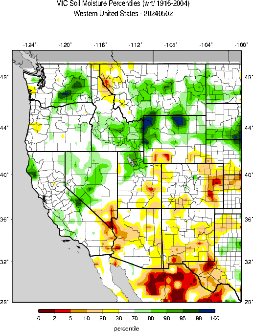
Here is the May one-month drought forecast which was issued on April 30, 2019.

These two forecasts are issued by the same agency but to obtain them you need to access two different links here and here. The three-month Seasonal Drought Outlook will be updated on May 16, 2019.
Here is the discussion released on May 31, 2019
Latest Monthly Assessment – Minimal drought coverage (3.31% D1 or drier) continued across the contiguous United States through May 28. The remaining areas of drought in the Four Corner’s region, southeastern New Mexico and southwestern Texas are forecast to either improve or be removed by the end of June 2019. Other areas of drought in western and north central Washington and northern Idaho are forecast to persist due to insufficient precipitation predicted during June. June Climatology, WPC, and CPC precipitation outlooks at most time ranges out to a month favor drought development in southwestern and central Washington and northwestern Oregon. The June Drought Outlook for the Southeast is perhaps the most challenging part of this Outlook. Precipitation outlooks out to a month are mixed, with dryness favored early and late in June while above normal rains are expected during mid-month. The mid-month rainfalls do not appear to be enough to outweigh longer-term deficits, therefore drought persistence is depicted. Also, several temperature outlooks out to a month favor above normal temperatures across the region, thus drought could develop in parts of Alabama, Georgia, Florida, South Carolina and North Carolina by the end of June where D0 existed.
Persistence and development of drought is favored for most parts of the southeastern Alaska Panhandle, which is heading into a climatologically drier time of year. Low reservoirs are anticipated to continue to have an impact on hydropower generation in the region. Hawaii is also entering a drier time of year, and the seasonal increase and consistency of easterly trade winds favor heavy precipitation along the windward (east or northeast-facing) slopes. Accordingly, drought persistence is expected for the leeward slopes of Hawaii. Drought persistence is also favored in interior portions of central and southwestern Puerto Rico since forecast rainfall is not expected to be enough to offset 60-day rainfall deficits (4-8 inches).
Additional Information Relative to the Intermediate-Term Forecast
We provided the summary approximately 25 Day Forecast earlier. Here is additional information that relates to this forecast.
First, the weather hazards forecast.


Additional information can be obtained here. We also now publish a Live Severe Weather article. The link to our Severe Weather Events article changes every Sunday night and the current version can always be found in the Directory which can be accessed here.
And we do not want to ignore floods which we also discussed in Section I.
| Last Week | Current Week |
|
|
Let’s see if this animation works.

Here are additional useful graphics from my weekly report which update automatically. The forecast maps were shown in the Introduction.
First the Day 3 Mid-Atmosphere pattern.


The below is of interest.

6. Soil Conditions and Crop Reports

We will now start reporting on evaporation

| Topsoil | Subsoil |
 |  |
Soil Conditions
|

Here is another way to look at it based on model results.

| And looking at the West. |
|

| Corn | Very Bad | Rice | Very Bad |
| Soybeans | Very Bad | Oats | Bad |
| Winter Wheat | Bad | Barley | Bad |
| Cotton | Slightly Bad | Spring Wheat | Bad |
| Sorghum | Very Bad | Peanuts | Good |
| Sugarbeet | Slightly Bad | ||
| Sunflowers | Very Bad |


7. International

A map helps and is not always available but is this week

8. Background Information


The sequence of drought occurrence and impacts for commonly accepted drought types. All droughts originate from a deficiency of precipitation or meteorological drought but other types of drought and impacts cascade from this deficiency. (Source: NDMC)
Source: National Drought Mitigation Center, University of Nebraska-Lincoln


