Written by Sig Silber
At the end of every month, NOAA issues an update to their Early Outlook for the following month, in this case, March 2020, which was issued on the Third Thursday of the month just finished. Today, nine days later, NOAA has issued their updated Outlook for March, the differences are remarkable and we do not have full confidence in the new forecasts either. We believe that JAMSTEC was correct that the transition from El Nino to ENSO Neutral was complicated by the Modoki-like pattern in the Pacific but that seems to be coming to an end – NOAA forecasting may now become more reliable.

Some housekeeping: On February 22, 2020, we published Part I of our analysis of the NOAA and JAMSTEC Three- to Four- Season Outlook and that can be accessed here. In that report, the March 2020 Early Outlook was issued. This article presents the NOAA update of their Early Outlook for March and the most recent Drought Update.
Please share this article – Go to the very top of the page, right-hand side for social media buttons. Also, feel free to send this article to anyone you feel will benefit from it. You can find the latest version of all our weather articles by consulting the Directory by clicking here and then clicking on the latest version of the article which is of interest to you.
Now let us address the NOAA Update of the March 2020 Forecast.
A note about terminology; the deviations from climatology/normal are color-coded but also labeled “A” for more than (above) normal and “B” for less than (below) normal. The area designated EC means Equal Chances of being more or less than normal. In the Short Term forecasts, NOAA has switched from using EC to N for Normal. For most purposes, EC and N can be considered to mean about the same thing. “N” implies a bit more certainty that the variation from Normal/Climatology will be small compared to “EC”.
First, we will compare the NOAA Early Outlook for March 2020 with the newly issued update.
Early Outlook Temperature

Updated Temperature Outlook

Early Outlook Precipitation

Updated Precipitation

| February 20, 2020 Forecast for March 2020 | February 29, 2019 Forecast for March 2020 | |
| Temperature |
|
|
| Precipitation |
|
|
Here is the discussion released today:
30-DAY OUTLOOK DISCUSSION FOR MARCH 2020
The updated March temperature and precipitation outlooks have been adjusted primarily from dynamical model forecast guidance from across multiple time scales and resulted in the need to make large changes from the mid-month previously released March outlook. The favored large scale 500-hPa height pattern depicts on average predominately the influence of Pacific air into the CONUS. Mean troughing near and over the far western CONUS, anomalous west-southwesterly flow and mean ridging and positive 500-hpa height departures across the central and eastern CONUS are most likely for much of March 2020. This is consistent from the short-range to Week 3-4 forecast time scale.
The March temperature outlook favors above-normal monthly mean temperatures for the eastern two-thirds of the CONUS with the highest probabilities stretching from the lower Mississippi Valley to the lower Great Lakes. Troughing to the north of Alaska and negative 500-hPa height departures and strongly elevated odds for above-normal precipitation favor below-normal temperatures for the southern half of Alaska and the Alaska Panhandle, extending southward to the northern Pacific Northwest. There remains slightly increased odds for above-normal temperatures for the north slope of Alaska. An expected highly varying pattern across the far western CONUS along with varying forecast signals over the course of the month make EC or “Equal-chances” for either below-, near- or above-normal temperatures” the best forecast for much of the far western CONUS.
For precipitation, variations in dynamical model guidance across time scales from the beginning of the month to the end of the month complicate the forecast of monthly total precipitation amounts. During the first week of March, heavy precipitation is favored for an area centered across the Tennessee Valley favoring elevated odds for above-normal precipitation in this region. Mode predictions support this area remaining just north of the Gulf coast with a tight gradient in precipitation so slightly elevated odds for below-normal precipitation remain forecast in this area.
Troughing entering the southern West coast and migrating into the western CONUS during Week-2 favors above-normal precipitation for parts of California and the Southwest. Potential phasing with the northern polar jet stream favors above-normal precipitation for the far northern great Plains, upper Midwest and Great Lakes during Weeks 2-3. A strong Pacific jet impacting Alaska favors high odds for above-normal precipitation for much of Alaska during March 2020. There are slightly elevated odds for below-normal precipitation for areas of the central Plains due to a high likelihood of no precipitation during the first week of March and only modest odds of above-normal precipitation through mid and later portions of the month. Although confidence is generally low in this region, monthly model integrations support this forecast.
Visual Consistency Testing.
It is useful to see how the full-month forecast fits with the set of partial-month forecasts that we have. These will continue to update in this article. It is important to remember that with the partial-month forecasts, we generally have about 25 days of the subsequent month to look at when we do this at the end of the month as we are doing now. It depends on what day of the week the month ends. So this month, which ended on a Saturday, we are only missing a forecast specific to the last four days of the month. So we are in very good shape for the visual consistency testing this month.
First Temperature
 |  |  |  |
| The new monthly forecast is to the right. Does it appear to be reflective of the four parts of the month for which we have forecasts? → |
| ↑ ← The Week 3 – 4 forecast was updated Friday so we will not need to update the commentary when the Week 3 – 4 update is reissued. At this point, we have forecasts for 27 days of the 31 days in March and the fit looks pretty good except for the West Coast which would appear to be cool not EC*. | |
And Precipitation
 |  |  |  |
The new monthly forecast is to the right. Does it appear to be reflective of the four parts of the month for which we have forecasts? → |
| ↑ ←The Week 3 – 4 forecast was updated Friday so we will not need to update the commentary when the Week 3 – 4 update is reissued. At this point, we have forecasts for 27 days of the 31 days in March February and the fit looks pretty good. But the sum of the short=term forecasts suggests a wetter West and Northern Tier* | |
* We have been advised by NOAA to take into account the lower confidence in the later time periods when making the monthly forecast. They take that into account. We do not have the ability to do that and treat each time period with the same level of confidence which is clearly inappropriate. Nevertheless, sometimes the discrepancies are so large that we feel justified in stating them. But when you work out the probabilities the differences may fit better than when we assign equal probabilities to the later parts of the month as to the early parts. The reader is free to second guess our analysis.
Because of the large differences between the monthly forecasts and the sum of the parts, we decided to also provide the Week 3 – 4 Discussion that was also released Friday. We are trying to understand if the assumptions and analysis in the full-month discussion are different than the assumptions and analysis in the Week 3- 4 discussion.
ENSO-neutral conditions are present across the equatorial Pacific Ocean. Equatorial sea surface temperatures (SSTs) are near-to-above average across the Pacific Ocean. The MJO is weak, with little model agreement on the forecast MJO evolution over the next two weeks. The Week 3-4 Outlook is based primarily on dynamical model forecasts, including the NCEP CFS, ECMWF, and JMA ensemble prediction systems, as well as the Subseasonal Experiment (SubX), a multi-model ensemble (MME) of both operational and experimental ensemble prediction systems. A multivariate linear regression (MLR) of lagged temperature and precipitation forecasts to currently observed MJO and ENSO indices and long-term trends, is also consulted, but given weak MJO and ENSO forcing, this tool reflects the linear trend.
The dynamical model consensus predicts a fairly high-amplitude 500-hPa height pattern, with anomalous ridging forecast south of the Aleutians, troughing near the West Coast, and ridging over eastern North America. There is excellent agreement among dynamical models on these broad features. Negative height anomalies are forecast over the polar latitudes, with below-normal heights forecast over the mid-latitudes; this means the dynamical model consensus favors a positive phase of the Arctic Oscillation lasting on average through March.
The surface temperature and precipitation patterns fall out nicely from the forecast circulation pattern. Above-normal temperatures are likely over the eastern two-thirds of the CONUS, with below-normal temperatures only favored along the West Coast extending northwestward into southern Alaska. There is more uncertainty in the precipitation outlook where various model tools are in poor agreement. The large-scale circulation pattern produces the highest confidence over Alaska, with above(below)-normal precipitation favored over the northern (southern) part of the state. Over the CONUS, wetter-than-normal conditions are broadly favored over the northern tier with anomalous upper-level southerly flow forecast. Below-normal precipitation is more likely over much of the southern and eastern CONUS due to the position of the anomalous ridge axis. Model tools disagree over parts of the Southeast and Tennessee River Valley, where SubX guidance is substantially wetter than the operational guidance, leading to EC being depicted for that region. Likewise, operational ensemble means favor above-normal precipitation for northern California, but calibration and incorporation of the SubX guidance reduced the probabilities to approximately equal changes.
SST anomalies remain slightly above-normal in the vicinity of Hawaii, although the magnitude of the anomalies has decreased substantially over the past several weeks. Dynamical model forecasts, including the SubX suite, generally support above-normal temperatures across Hawaii, but the ECMWF has a cooler solution. Dynamical models generally favor enhanced precipitation.
Since the Week 3 – 4 Forecast mentioned the Arctic Oscillation (AO), I thought it useful to show the history and forecast of the AO.
I have included the NAO also even though it was not mentioned in either the monthly forecast discussion or the Week 3 – 4 discussion and it is very related to the AO 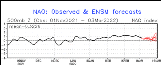
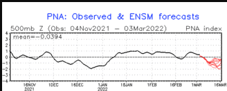
You can see the impact of the different phases in the schematics below (Source: N.C. State Climatologist). PNA Positive in on the left and PNA Negative on the right. PNA Negative is a pattern that is more westerly located than PNA Positive. This has to do with storms entering CONUS in the Northwest and then moving south either closer to the coast or further inland.
………………………..PNA Positive…………………………….. PNA Negative……………..

PNA Negative kind of conflicts with a strong ridge of High Pressure in the Gulf of Alaska.
Forecasts for these indices and others are always in the Addendum of the LIVE Current weather and forecast article for readers and these forecasts auto-update ( I have not frozen them in this article either).and for those with an interest in more detail, the LIVE article allows one to access current NOAA Warnings and details associated with those warnings.
Sometimes it is useful to compare the three-month outlook to the forecast for the first of the three months. It shows how much the pattern changes over the three-month period.

One can mentally subtract the First-Month Outlook from the Three-month Outlook and create the Outlook for the last two months in the three-month period.
And with respect to drought, this was also issued on February 29, 2020.

Discussion for the Monthly Drought Outlook
Tools used in the U.S. Monthly Drought Outlook (MDO) include the Climate Prediction Center (CPC) temperature and precipitation outlooks for February, various short- and medium-range forecasts and models such as the 7-day quantitative precipitation forecast (QPF) from the Weather Prediction Center (WPC), the 6-10 day and 8-14 day CPC extended-range forecasts (ERFs), the Weeks 3-4 outlooks and tools from CPC, dynamical models at the monthly time scale, the 384-hour total precipitation forecasts from several runs of the GFS, and February climatology. Initial conditions are based on the February 25, 2020 U.S. Drought Monitor. ENSO-neutral conditions are present, and are favored through the Northern Hemisphere spring 2020, continuing through summer 2020.
Over the next 7 days, precipitation is expected in coastal areas of the Pacific Northwest and Cascades (West Region). Portions of central and southern California and the Sierra Nevadas are also expected to see some precipitation over the next 7 days, particularly in southeastern portions of the D1 area in central California. In addition, anomalous mean troughing over the Pacific is expected to progress eastward into the West late in the Week 2 period and early in the Weeks 3-4 period, elevating chances for much needed precipitation for central and southern California and portions of the Southwest and Four Corners region. However, amounts in California are likely not to be substantial enough to overcome the antecedent dryness already in place. This is particularly true in areas near Santa Barbara and San Luis Obispo, California, which have already seen an early departure of rangeland vegetation, forcing farmers to begin supplementing their feed stock due to an abnormally dry January and February. Development in the Sierra Nevadas, near Lake Tahoe, is favored in association with below-normal snowpack (50 to 75 percent of normal) coupled with antecedent dryness. As such, drought development is favored for portions of central and northern California (from Santa Barbara northward), western Nevada, and interior areas of Oregon. Existing drought is expected to persist throughout the forecast period as the pattern is favored to be fairly transient across the region, with absent-to-weak precipitation probabilities.
Forecast confidence is high for the Four Corners region, moderate for the Pacific Northwest, and low elsewhere for the West Region.
Much of the High Plains Region has seen above- to near-normal precipitation over the past 90 days, with the exception of portions of Colorado and Utah and extreme southwestern Kansas. Precipitation is expected to fall over much of Utah and Colorado over the next 7 days, but amounts are expected to be near-normal. Below- and above-normal precipitation for the Four Corners region is favored for the 6-10 and Week 2 periods, respectively, with equal chances favored for the remainder of the forecast period. The rest of the High Plains also favor a transient pattern. As a result, drought persistence is favored for areas in Utah and Colorado, with no development likely elsewhere for the High Plains Region.
Forecast confidence is moderate for the High Plains Region.
Much of the Midwest has seen well above-normal precipitation, with widespread water-year-to-date water-year-to-date (WYTD) precipitation of 150 to 200 percent of normal. Above-normal precipitation is favored for much of the upper-Midwest for March, while the Ohio Valley is favored to see more variability throughout the forecast period. As such, no drought development is likely for March.
Forecast confidence is high for the Midwest Region.
In the first few days of the period, a low-pressure system is favored to develop over the southern Great Plains (South Region) and propagate eastward. Another potential round of moisture near the beginning of the Weeks 3-4 period could offer another opportunity for additional precipitation. However, there is great uncertainty in the intensity and track of these potential low-pressure systems and where trailing frontal boundaries set up. With year-to-date (YTD) precipitation deficits of 2 to 4 inches north and west of the Houston metro area, and WYTD anomalies of negative 8 to 12 inches over these same areas, along with widespread 4 to 6 inch deficits, drought persistence is favored for Texas. Drought development is expected along coastal areas of Texas, southward from Houston, as YTD precipitation is 50 to 75 percent of normal and February saw less than 5 percent of normal precipitation for many of these areas. The lack of a precipitation signal for March further supports this development, given the dry antecedent conditions. Development is also favored near and west of San Antonio, where 30 day deficits have reached 1-2 inches and precipitation is favored to be near- to below-normal for March. Additional drought development is favored over extreme southeastern areas of Louisiana, which have become progressively drier over the past 6 months (precipitation is 50 to 75 percent of normal over the past 180 days and 25 to 50 percent of normal over the past 30 days).
Forecast confidence is low for the South Region.
YTD precipitation was 50 to 75 percent of normal for portions of New England and Maine (Northeast Region). However, February saw near- to above-normal precipitation for many of these areas. The rest of the Northeast has seen above-normal precipitation for the past 90 days. In addition, above-normal precipitation is favored for much of this region through Week 2. As such, no drought development is likely.
Forecast confidence is high for the Northeast Region.
Large areas of the Southeast and Tennessee Valley have seen 12 inch surpluses or greater of precipitation over the past 90 days. Unfortunately, this has not been the case for areas along the Gulf Coast. A transient pattern is expected over much of the Southeast, with above-normal precipitation favored north of the Gulf Coast and into the Tennessee Valley. Below-normal precipitation is favored in central and southern portions of the Florida Peninsula, which have seen widespread areas of 25 to 50 percent of normal YTD precipitation, supporting some drought development in D0 areas there. No drought development is favored elsewhere for the Southeast.
Forecast confidence is low for Florida, and high elsewhere for the Southeast Region.
Mainland Alaska has seen an active storm track in recent weeks and this is expected to continue through March, while the precipitation signal over the Alaska Panhandle is favored to be absent to weakly below-normal. However, with much of the panhandle seeing above normal precipitation in recent weeks, the absent to weakly dry signals do not warrant any drought development along the panhandle at this time. As such, no drought development is expected for Alaska.
Forecast confidence is high for the Alaska Mainland, and moderate for the Alaska Panhandle.
Drought conditions in Hawaii have continued to improve in recent weeks. Continued improvement (D2 in Molokai) and removal (elsewhere) are favored as models are in strong agreement for above-normal precipitation for all of Hawaii for March.
Forecast confidence is high for Hawaii.
Eastern portions of the D0 area in northwestern Puerto Rico have seen 1 to 2 inches of rainfall over the past 7 days. The absence of a precipitation signal for March over this region in the models supports status quo for now. Therefore, no drought development favored for Puerto Rico.
Forecast confidence is high for Puerto Rico
Looking back on February to relate the forecast for March to the actuals in February.
First February Temperature (28 out of 29 days).

And then February Precipitation (28 out of 29 days).

We then show the new forecast and the prior month actuals (less one day) side by side.
| Prior Month (usually missing one day) | Forecast for current Month | |
| Temperature |
|
|
| Precipitation |
|
|
Conclusion
The purpose of this article was to present the updated Outlook for March 2020 and compare it with the Early Outlook. It is not to critique the updated Outlook for March based on our opinions but we point out possible inconsistencies if we find them. We have assessed the extent to which the monthly outlook seems to fit with the other forecasts provided by NOAA. In reality, all forecasts are obsolete when issued as the situation changes day by day or six hours by six hours i.e. each new model run. In our other articles, we continually examine the current forecasts from NOAA including the Day 1- 5, 6-10, 8-14 and Week 3 and 4. So we are continually looking at approximately 25 days into the future.
On March 12, 2020, IRI/CBC will issue their ENSO forecast and we will present that and critique it. It is an ongoing process and we attempt to provide our readers with the best current assessment of the next approximately 25 days (except when we cover the Four-Season Analysis or medium-frequency cycles such as ENSO), so our analysis is pretty much ongoing. We also publish a “LIVE” Weather Article which updates in real-time to reflect NOAA Weather Headlines and for those interested provides detailed information down to current warnings in place. All of our reports including past versions of these reports can be located via the Directory/Archive which can be accessed here.


