Written by Sig Silber
Updated at 5:15 pm Friday, January 3, 2020, to report on the Week 3 – 4 Forecast and to update our assessment of what January will look like based on the current forecasts.
At the end of every month, NOAA issues an update to their Early Outlook for the following month, in this case, January 2020, which was issued on the Third Thursday of the Month. Today, twelve days later, NOAA has issued its updated Outlook for January. It is dramatically different than the Early Outlook especially for temperature and reading the discussion suggests that there remain some significant uncertainties.

Some housekeeping: On December 20, 2019 we published Part I of our analysis of the NOAA and JAMSTEC Three – to Four- Season Outlook and that can be accessed here. In that report, the January Early Outlook was issued. This article presents the NOAA update of their Early Outlook for January.
Please share this article – Go to the very top of the page, right-hand side for social media buttons. Also, feel free to send this article to anyone you feel will benefit from it. You can find the latest version of all our weather articles by consulting the Directory by clicking here and then clicking on the latest version of the article which is of interest to you.
Now let us address the NOAA Update of the January, 2020 Forecast.
First an Editor’s Note: which is it NOAA? From your discussion:
The updated January 2020 temperature outlook depicts large differences from the 0.5-month lead outlook issued in mid-December. This is due in large part to a temporary, expected weakening of a mid-level ridge over the Gulf of Alaska and the resulting shift in the storm track.
or is it
A broad region of above normal (upper tercile) precipitation is favored over much of western and central Alaska, associated with a predicted strong mid-level ridge over the Gulf of Alaska and accompanying low-level onshore flow.
We may be talking about different parts of the month but it does seem confusing.
To help understand this I referred to the Addendum to our LIVE ALL WEEK Article. Please do not be put off by the date on that Addendum. The Date does not change because all the graphics auto-update and therefore we have no need to republish the Addendum but perhaps we should to avoid readers thinking it is out of date. At any rate from the Addendum to our LIVE ALL WEEK article (you can find the latest version of LIVE ALL WEEK in the Directory of Sig Silber Weather Articles. Select and click on the version at the top of the stack. And to get to the Addendum, click on the link labeled MORE WEATHER Addendum
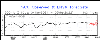
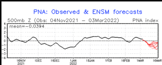
We are now going to look at the forecast for the AO, NAO and PNA. They are always there for readers and auto-update.


Back to our Normal Format and Discussion
A note about terminology; the deviations from climatology/normal are color-coded but also labeled “A” for more than (above) normal and “B” for less than (below) normal. The area designated EC means Equal Chances of being more or less than normal. In the Short Term forecasts, NOAA has switched from using EC to N for Normal. For most purposes, EC and N can be considered to mean about the same thing. “N” implies a bit more certainty that the variation from Normal/Climatology will be small compared to “EC”.
First, we will compare the NOAA Early Outlook for January, 2020 with the newly issued update.
Early Outlook Temperature

Updated Temperature Outlook

Early Outlook Precipitation

Updated Precipitation

| December 19, 2019 Forecast for January, 2020 | December 31, 2019 Forecast for January, 2020 | |
| Temperature |
|
|
| Precipitation |
|
|
Here is the discussion released today:
30-DAY OUTLOOK DISCUSSION FOR JANUARY 2020
The updated monthly temperature and precipitation outlooks for January 2020 are based on the latest dynamical model guidance (such as the CFS, ECMWF, and GEFS), WPC temperature and precipitation forecasts for the first week of January, and CPC’s 6-10 day, week 2, and week 3-4 temperature and precipitation outlooks. The Madden-Julian Oscillation (MJO) is currently weak and may undergo strengthening during the next several weeks. At this time, the MJO is not expected to play a significant role in the mid-latitude circulation over the United States during January.
The updated January 2020 temperature outlook depicts large differences from the 0.5-month lead outlook issued in mid-December. This is due in large part to a temporary, expected weakening of a mid-level ridge over the Gulf of Alaska and the resulting shift in the storm track. The updated outlook favors increased chances of below normal (lower tercile) temperatures across much of Alaska, and for most areas west of the Continental Divide. This is based on a general consensus of the following models/tools, which in some cas es vary quite a bit: the latest few runs of the CFS model (though it predicts above normal temperatures for Washington state), WPC’s temperature forecast for week 1, CPC’s 6-10 day, week 2, and week 3-4 outlooks, and temperature predictions from the ECMWF model. ECMWF temperature departures for the second half of January indicate below normal temperatures across the entire West, the northern half of the Great Plains, and into the Upper Mississippi Valley, as well as the southern third of mainland Alaska and the Southeast Panhandle region. Above normal (upper tercile) temperatures are favored for approximately the southeast quadrant of the contiguous U.S. This is also based on a broad consensus of the following models/tools: WPC’s temperature forecast for week 1, CPC’s week 2 and week 3/4 temperature outlooks, and temperature predictions from the ECMWF model. The exception is CPC’s 6-10 day temperature forecast, which depicts near to below normal temperatures over the eastern half of the CONUS. During the past several days, the CFS model predicted only spotty areas of above normal temperatures over parts of the Southeast, and most recently, the Mississippi Valley. With good agreement among assorted tools on above normal temperatures over the Southeast, probabilities exceed 60% in Florida. For most of the northeast quadrant of the CONUS, the Great Plains, northern and central portions of California and adjacent parts of Nevada, there are weak and/or conflicting signals among the temperature outlooks and tools (consistent with the expectation of high short-term climate variability) resulting in a forecast of Equal Chances (EC). EC is also indicated for remaining parts of Alaska.
The updated precipitation outlook for January 2020 also depicts significant changes from the 0.5-month lead precipitation outlook issued in mid-December. A broad region of above normal (upper tercile) precipitation is favored over much of western and central Alaska, associated with a predicted strong mid-level ridge over the Gulf of Alaska and accompanying low-level onshore flow. The latest few runs of the CFS have trended towards a southeastward shift of the anticipated anomalously wet region, and increasing odds of dryness across the northwest part of the state. Upper tercile precipitation is also favored over the northern Great Plains and from the south-central Mississippi Valley eastward and northeastward to the Mid-Atlantic Coast. These latter areas of favored upper tercile precipitation are based on a broad consensus of precipitation outlooks from WPC and CPC out to a month in advance, and to various degrees the last 9 days of CFS runs. The northern Plains represents the southern edge of a very extensive region of negative height anomalies at 700-hPa (CFS model) that wraps around the northern and eastern sides of the strong block predicted over the Gulf of Alaska. The area of favored upper tercile precipitation depicted over the southeastern portion of the CONUS (where probabilities for above normal precipitation exceed 50% over the Tennessee Valley) is suggestive of the mean position of frontal zones. A significant fraction of the precipitation that is forecast across the Tennessee Valley is expected to fall during the first week to ten days of January. For California, there is significant uncertainty in the predicted precipitation pattern, which looked rather dry in yesterday’s tools. CPC’s week 2 outlook and today’s ECMWF precipitation output valid for the second half of January depict wetter-than-usual conditions. When considered against the backdrop of some models/tools favoring dryness, it was decided to keep California as EC.
Visual Consistency Testing.
It is useful to see how the full-month forecast fits with the set of partial-month forecasts that we have. These will continue to update in this article. It is important to remember that with the partial-month forecasts, we generally have about 25 days of the subsequent month to look at when we do this at the end of the month as we are doing now. It depends on what day of the week the month ends. So this month, which ended on a Tuesday, four days after the Week 3 – 4 forecast was issued, we are missing a forecast specific to the last seven of the month. We will have that on Friday.
First Temperature
 |  |  |  |
| The new monthly forecast is to the right. Does it appear to be reflective of the four parts of the month for which we have forecasts? → |
| ↑ ← The Week 3 – 4 forecast was updated Friday, January 3 so now we have forecasts for all of the 31 days in January and the fit looks pretty good. But the warm anomaly seems to have been understated in the monthly forecast re the Great Lakes to the Northeast and New England. And the cool anomaly would appear to apply to Northern California also and be overall more robust. | |
And Precipitation
 |  |  |  |
The new monthly forecast is to the right. Does it appear to be reflective of the four parts of the month for which we have forecasts? → |
| ↑ ←The Week 3 – 4 forecast was updated Friday, January 3 so now we have forecasts for all of the 31 days in January and the fit looks pretty good. The month may be slightly wetter than the full month forecast indicates. | |
Here is the January 3, 2020 Day 6 – 14 discussion and the discussion released on January 3, 2020 with the Week 3 – 4 Forecast.
6-10 DAY OUTLOOK FOR JAN 09 – 13 2020
Today’s model solutions are in good agreement on the 500-hPa height pattern over the forecast domain for the 6-10 day period. The manual 500-hPa height blend is based primarily on the ensemble means from the GFS, ECMWF, and Canadian models. The resultant manual blend features very strong ridging over the Northeast Pacific, with a height anomaly center exceeding 390 meters in today’s manual blend. Negative 500-hPa height anomalies and troughing are forecast over the western and central CONUS, while positive 500-hPa height anomalies are forecast over the eastern CONUS. Above normal 500-hPa heights are forecast over the Aleutians, and southwestern Mainland Alaska with below normal 500-hPa heights over the remainder of Mainland Alaska and the Alaska Panhandle.
There are enhanced probabilities of below normal temperatures across most of the western CONUS and the Northern Plains underneath predicted troughing and negative 500-hPa height anomalies. Above normal temperatures are favored over most of the eastern CONUS and the Southern Plains, which is consistent with the GEFS reforecast tool. Near to below normal temperatures are likely over Mainland Alaska and the Alaska Panhandle, while above normal temperatures are favored over the Aleutians, supported by the operational autoblend temperatures and ERF Consolidation forecast tools.
Above normal precipitation probabilities are increased across the Pacific Northwest, extending through the Plains and into most of the eastern CONUS in association with the trough predicted over the western CONUS and more active storm tracks. Conversely, there are enhanced probabilities of below normal precipitation over southern California, consistent with the GEFS and ECMWF reforecast tools. Most of today’s models support increased above normal precipitation probabilities for the Aleutians and southern Mainland Alaska, while below normal precipitation probabilities are favored for parts of the northern Mainland Alaska.
The official 6-10 day 500-hPa height blend consists of 25% of Today’s 0z GFS Ensemble Mean centered on Day 8, 25% of Today’s 6z GFS Ensemble Mean centered on Day 8, 30% of Today’s 0z European Ensemble Mean centered on Day 8, and 20% of Today’s 0z Canadian Ensemble Mean centered on Day 8
FORECAST CONFIDENCE FOR THE 6-10 DAY PERIOD: Above average, 4 out of 5, due to relatively good agreement between models on the predicted 500-hPa height pattern, and among the temperature and precipitation forecast tools.
8-14 DAY OUTLOOK FOR JAN 11 – 17 2020
During the Week-2 period, ensemble means feature an amplified ridge from the Northeast Pacific north to the Bering Strait and a trough over western North America. Negative 500-hPa height anomalies are forecast over most of the western and central CONUS, while positive 500-hPa height anomalies are forecast over the eastern CONUS. Above normal 500-hPa heights are forecast over the Aleutians and most of the western Mainland Alaska with below normal 500-hPa heights over the remainder of Mainland Alaska and the Alaska Panhandle.
Above normal temperatures are favored for most of the eastern CONUS as guidance has continued to trend warmer, supporting the already warmer statistical tools. Further west, troughing and below normal 500-hPa heights favor enhanced below normal temperature probabilities. Near to below normal temperatures remain favored for most of Alaska underneath expanding troughing across the western CONUS and Canada, protruding into Alaska. Over the Aleutians, increased near to above normal temperature probabilities are forecast, closer to the anomalous ridge in the Northeast Pacific.
The amplifying mid-level pattern favors a tilt toward above normal precipitation for most of the CONUS. Troughing and several storm systems forecast to develop over the western CONUS favor an increase in precipitation over the western CONUS. Southerly flow and increased storm activity are forecast to increase across the East, favoring a wetter pattern. Increasing chances of near to above normal precipitation are forecast for the Aleutians and most of Mainland Alaska, while below normal precipitation is favored over much of the Alaska Panhandle, supported by the GEFS and ECMWF reforecast tools.
The official 8-14 day 500-hPa height blend consists of: 25% of Today’s 0z GFS Ensemble Mean centered on Day 11, 25% of Today’s 6z GFS Ensemble Mean centered on Day 11, 30% of Today’s 0z European Ensemble Mean centered on Day 11, and 20% of Today’s 0z Canadian Ensemble Mean centered on Day 11
FORECAST CONFIDENCE FOR THE 8-14 DAY PERIOD: Above average, 4 out of 5, due to good agreement between models on the predicted 500-hPa height pattern, and among the temperature and precipitation forecast tools.
Week 3-4 Forecast Discussion Valid Sat Jan 18 2020-Fri Jan 31, 2020
The global tropical convective pattern remains weak, with ENSO-neutral conditions prevailing, an incoherent MJO signal, and a decaying Indian Ocean Dipole (IOD). Therefore, little contribution from the tropics to the downstream midlatitude pattern during the Week 3-4 period is evident in the statistical guidance. Dynamical models almost uniformly favor renewed MJO activity, however, with the enhanced phase crossing the Maritime Continent over the next two weeks at a high amplitude on the RMM-based MJO index. The weakening IOD signal effecting a change in the base state may partly explain the forecasted high amplitude signal, but should a robust MJO event develop and propagate to the Pacific, it could help promote a substantial late winter pattern change over North America. These impacts would occur largely after the Week 3-4 period.
Dynamical model 500mb height forecasts for Week 3-4 are remarkably consistent this week, both among the different model ensembles and through several runs of each model. The overall pattern described by the guidance is also consistent with the predicted Week-2 pattern, featuring a high amplitude ridge south of the Aleutians, Arctic air over Canada, a trough extending into the western CONUS which may promote cold air outbreaks in the West or across the Northern Plains, and a ridge over the Southeast. The CFS places the trough further east than the ECMWF, while the JMA keeps the cold air locked more in the West and Canada. The overall consistency among the dynamical model guidance allows for increased confidence of the forecast.
The Week 3-4 temperature outlook is based primarily on the autoblend of the CFS, ECMWF, and JMA dynamical models and the multiple linear regression (MLR) statistical tool that is based on ENSO, MJO, and long-term trends. Given the weak signals in the tropics, the trends are the largest contributor to the MLR forecast, and where the trends conflict with the dynamical model guidance, the dynamical models are favored. Enhanced chances for below-normal temperatures extend across much of Alaska except the North Slope, the western third of the CONUS, and the Northern Plains and upper Midwest. Dynamical models also indicate a potential for below-normal temperatures across northern New England. In contrast, above-normal temperatures are favored across Texas and along and east of the Mississippi River except New England. The area of greatest uncertainty is the Central and South-Central Plains, where long-term trends are positive (and thus reflected in the autoblend where dynamical model guidance is mixed), but the anticipated pattern leaves open the possibility for periods of cold air intrusion extending southward to the Central Plains.
The precipitation outlook is more sensitive to subtle differences in the forecast pattern, and therefore uncertainty is much higher than in the temperature outlook. The presence of a Southeast ridge favors northward advection of abundant Gulf of Mexico moisture ahead of a mean frontal boundary near the Mississippi River. Therefore, enhanced chances for above-median precipitation extend across the Southeast and Ohio River Valleys, extending as far north as southern New England and the eastern Great Lakes. The precipitation pattern across the western US is highly uncertain, with the ECMWF favoring enhanced moisture across California and the Great Basin, and the CFS and JMA drier. Strong negativeThe major purpose of this exercise was to review
First an Editor’s Note: which is it NOAA? From your discussion:
The updated January 2020 temperature outlook depicts large differences from the 0.5-month lead outlook issued in mid-December. This is due in large part to a temporary, expected weakening of a mid-level ridge over the Gulf of Alaska and the resulting shift in the storm track.
or is it
A broad region of above normal (upper tercile) precipitation is favored over much of western and central Alaska, associated with a predicted strong mid-level ridge over the Gulf of Alaska and accompanying low-level onshore flow.
It is too late from these discussions to review the notion that the Gulf of Alaska Ridge would weaken early in January.
So we take a look at the short term discussions.
…Locally heavy rain and thunderstorms possible across the Southeast today…
…Light to moderate snow expected for portions of the Midwest to Northeast…
…Precipitation continues in the Pacific Northwest through the weekend with high winds likely across the Northern High Plains…
An upper-level trough over the central U.S. will move across the eastern U.S. over the next couple of days, along with a couple of cold fronts at the surface. Rain will continue to spread across portions of the East today as ample moisture streams ahead of these features. Locally heavy rainfall, isolated flash flooding, and a few strong thunderstorms are possible across portions of the Southeast in particular. Temperatures will be mild this evening into Saturday morning, with record high minimum temperatures in the 60s and 70s possible tomorrow morning across Florida into the Georgia and Carolina coast.
A weak clipper system will track across the Midwest today and tonight, bringing light to locally moderate snow from southern Minnesota to central Illinois. As upper-level energy continues eastward, snow is expected to spread over the interior Northeast and higher elevations of the Central Appalachians on Saturday. Snow totals of 3 to 5 inches are currently forecast.
Farther west, a strong frontal system is forecast to push through the Paific Northwest tonight and move quickly southeastward across the Rockies and Great Basin Saturday. This will lead to heavy higher elevation snow in the Cascades, with snow in the Northern Rockies as well. Lower elevations and coastal portions of the Northwest should remain rain. High winds are also likely in the Northwest with a potent upper-level system and the aforementioned front. High Wind Watches and Warnings, as well as Wind Advisories are currently in place for portions of the Pacific Northwest and the Northern and Central High Plains.
By Sunday this system is forecast to enter the central U.S. and bring gusty winds across the Midwest, with light snow across the northern Great Lakes. Meanwhile, another round of rain and mountain snow will enter the Pacific Northwest on Sunday.
– Heavy precipitation across portions of the Pacific Northwest and the Northern Great Basin, Mon-Tue, Jan 6-Jan 7.
– Heavy rain across portions of the Lower Mississippi Valley, the Tennessee Valley, the Middle Mississippi Valley, the Southeast, the Southern Plains, and the Ohio Valley, Fri, Jan 10. – Heavy snow across portions of the Northeast, Wed, Jan 8.
– Flooding possible across portions of the Southeast and the Tennessee Valley.
– Flooding occurring or imminent across portions of the Northern Plains.
– Flooding likely across portions of the Southeast, the Lower Mississippi Valley, and the Tennessee Valley.
Sometimes it is useful to compare the three-month outlook to the forecast for the first of the three months. It shows how much the pattern changes over the three-month period.

One can mentally subtract the First-Month Outlook from the Three-month Outlook and create the Outlook for the last two months in the three-month period.
And with respect to drought, this was also issued on December 31, 2019.

Here is the short discussion issued with the new drought forecast.
Latest Monthly Assessment – Changes to drought conditions have been a mixed bag this past month. A trend toward gradual improvement continued in the Four Corners states, and drought also eased in most of the Southeast, across California and Nevada, and through parts of central and southern Texas. Across Deep South and Eastern Texas, however, conditions deteriorated, as they did in southernmost Florida and parts of the central Great Plains. Drought also developed in portions of the northern Intermountain West and Pacific Northwest.
Early in the late December and early January period, widespread precipitation is forecast to improve or remove drought in south-central Kansas and part of the Red River Valley. Smaller areas of drought in central and far southeastern Texas, east-central Louisiana, and the Florida Panhandle should also see conditions ease. Based on recent trends and precipitation so far this water year, some continued easing or removal of drought should occur in a swath from east-central Arizona through southwestern Utah, and near the middle of the Four Corners Region. Furthermore, an expected increase in rainfall should bring at least some drought improvement where it exists in Hawaii. The relatively small areas of drought in southeastern Alaska and southeastern Puerto Rico should persist, alond with southern Florida, where this is a dry time of year. Precipitation may be near or slightly above normal in most of central and northeastern Texas, the west-central Red River Valley, and much of the Four Corners States, but not enough to provide substantial drought relief. With low confidence, drought is forecast to persist in the northern Intermountain West and Pacific Northwest even though above-normal precipitation may fall during the first half of January. Recent moisture deficits and reduced snowpack may be slow to respond there.
Looking back on December to relate the forecast for January to the actuals in December.
First December Temperature (30 out of 31 days).

And then December Precipitation (30 out of 31 days).

We then show the new forecast and the prior month actuals (less one day) side by side.
| Prior Month (usually missing one day) | Forecast for current Month | |
| Temperature |
|
|
| Precipitation |
|
|
The purpose of this article was to present the updated Outlook for January 2020 and compare it with the Early Outlook. It is not to critique the updated Outlook for January based on our opinions but we point out possible inconsistencies if we find them. We have assessed the extent to which the monthly outlook seems to fit with the other forecasts provided by NOAA. We do not have a January forecast by JAMSTEC as they only provide three-month forecasts but we do have a recent December/January/February forecast from them this month.
We now show the three-month JAMSTEC forecast with the single month of January NOAA forecast.
| JAMSTEC DJF forecast made perhaps based on December 1 information | NOAA Forecast for current Month | |
| Temperature |
|
|
| Precipitation |
|
|


In reality, all forecasts are obsolete when issued as the situation changes day by day or six hours by six hours i.e. each new model run. In our other articles, we continually examine the current forecasts from NOAA including the Day 1- 5, 6-10, 8-14 and Week 3 and 4. So we are continually looking at approximately 25 days into the future.
On January 12, 2020, IRI/CBC will issue their ENSO forecast and we will present that and critique it. It is an ongoing process and we attempt to provide our readers with the best current assessment of the next approximately 25 days (except when we cover the Four-Season Analysis or medium-frequency cycles such as ENSO), so our analysis is pretty much ongoing. We also publish a “LIVE All WEEK” Weather Article which updates in real-time to reflect NOAA Weather Headlines. All of our reports including past versions of these reports can be located via the Directory/Archive which can be accessed here.


