Written by Sig Silber
We published the NOAA Long-Term Forecast Thursday Night (here). Now we compare the NOAA forecast for Alaska and CONUS with the JAMSTEC forecast. We also provide the JAMSTEC World Forecasts with special emphasis on Europe. This wee, we are not going to attempt to explain why the forecasts are different. In the future, we will start to compare the forecasts of the two agencies for CONUS with the actual weather that resulted. We have good data on that.

Please share this article – Go to the very top of the page, right-hand side for social media buttons. Please feel free to send this article to anyone who you think might find it interesting and or useful.
Comparison of the NOAA and JAMSTEC Forecasts Plus the Extracted JAMSTEC Europe Forecast.
Below is a the comparison of the NOAA and JAMSTEC temperature and precipitation forecasts for three time-periods and from left to right the NOAA forecast for Alaska and CONUS (the contiguous mid-latitude U.S), then JAMSTEC for North America (which includes Canada and Mexico), and then we also provide JAMSTEC for Europe and surrounding areas. The JAMSTEC graphics in the Summary Table are not set up to be clicked on to enlarge. The NOAA forecasts can be clicked on to enlarge. We have concluded that these smaller images work fine for comparison purposes. Larger images for Alaska and CONUS can be found here.
Later in the article, we will the World Forecasts.
In the future, we may be showing not just the present forecasts but also the forecasts three-months earlier and the actual for that three-month period. The details of how we would present that information have yet to be worked out.
Temperature
| NOAA Alaska Plus CONUS | JAMSTEC North America | JAMSTEC Europe | |
JFM 2020 for NOAA DJF 2019-2020 for JAMSTEC |  |  |  |
Spring MAM 2020 |  |  |  |
Summer JJA |  |  |  |
Precipitation
| NOAA Alaska Plus CONUS | JAMSTEC North America | JAMSTEC Europe | |
Winter JFM 2020 for NOAA DJF 2019-2020 for JAMSTEC |  |  |  |
Spring MAM 2020 |  |  |  |
Summer JJA 2020 |  |  |  |
We provided the full NOAA Discussion in Part I. The much shorter JAMSTEC Discussion was published on December 13, 2019 so we have that for our Report tonight.
ENSO forecast:
As predicted earlier, the El Niño Modoki-like state has been observed. The SINTEX-F predicts that a weak El Niño-like pattern (possibly a mixture of Modoki-type and canonical-type) will persist at least until boreal summer of year 2020.
Indian Ocean forecast:
The strong positive Indian Ocean Dipole reached the peak in October-November, and then started to decay. The model predicts that the positive Indian Ocean Dipole will disappear in January.
Regional forecast:
On a seasonal scale, the SINTEX-F predicts that most part of the globe, particularly Eurasia and Canada, will experience a warmer-than-normal condition in boreal winter, except for some parts of U.S.A, eastern Russia, West/Central Africa and southwestern China. In boreal spring, almost all part of the globe will still experience a warmer-than-normal condition, except for some parts of southeastern Canada, northeastern U.S.A, Bangladesh, and its surrounding regions.
As regards to the seasonally averaged rainfall in boreal winter, a wetter-than-normal condition is predicted for Alaska, northwestern coastal area of Canada, eastern Brazil, East Africa, and northern part of Europe, and eastern China. In contrast, some parts of western U.S.A., northern part of the South American continent, western Brazil, southern/central Africa, southern part of Europe, most part of Southeast Asia, Indonesia, and Philippines will experience a drier-than-normal condition. In boreal spring of year 2020, a wetter-than-normal condition is predicted for eastern U.S.A., some parts of southern Africa, and Bangladesh. In contrast, western U.S.A., most part of eastern Brazil, western Australia, western part of southern Africa, West Africa, Europe, some parts of Southeast Asia, Philippines, and eastern China will experience a drier-than-normal condition.
The model predicts most part of Japan will experience warmer and slightly drier-than-normal condition in the coming winter and spring as a seasonal average.
JAMSTEC World Forecasts
Winter and for JAMSTEC means DJF and of course December is almost over but that is how they do it. They work with three-month seasons as they view Winter as DJF. My comments refer to areas other than Alaska and CONUS as we have discussed those earlier. We provide some comments but for Winter and Spring, the comments in the above JAMSTEC discussion tend to provide more detail.
| Temperature |
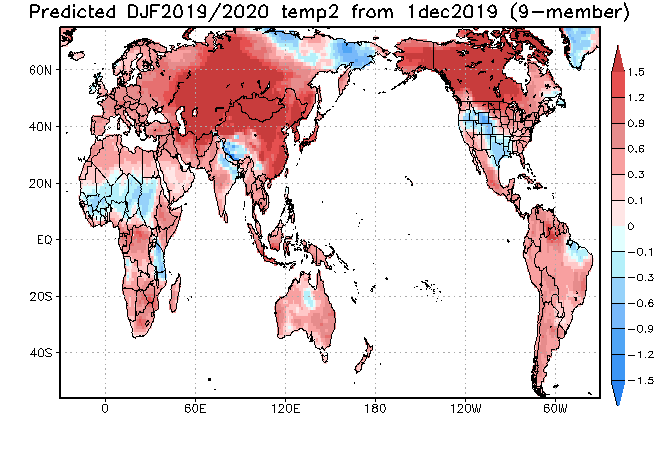 |
| With respect to temperature, Eastern Siberia is cool (cool meaning cooler than normal) and so is the area just north of Equatorial Africa. Southwestern China and Northeast India is cool also. Greenland is cool |
| Precipitation |
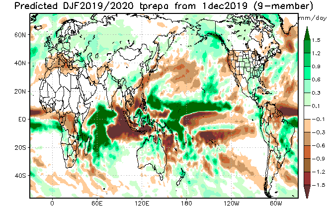 |
| For precipitation, Australia seems to be wetter than recently and Venezuela, Columbia, and Northern Brazil might be dry. Southeast Asia and part of the Maritime Continent might be dry. We have previously discussed the Mediterranean Region. |
Spring which is MAM
| Temperature |
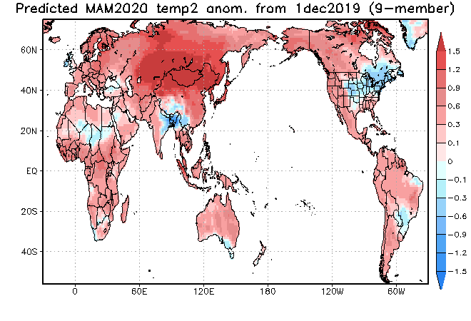 |
| Southwest China might be cool plus Bangladesh and Northeast India. Generally, it looks pretty warm outside of the U.S. Eastern Canada and Greenland. |
| Precipitation |
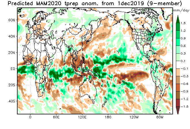 |
| Australia returns to being dry. Southern South America is dry. Parts of Southeast Asia and parts of the Maritime Continent remain dry. |
And Summer which is JJA
| Temperature |
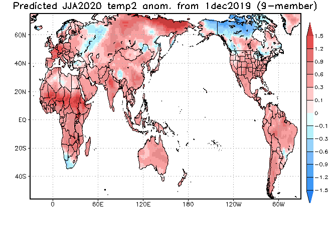 |
| Eastern Russia and Western Canada are cool but overall the World is warm. |
| Precipitation |
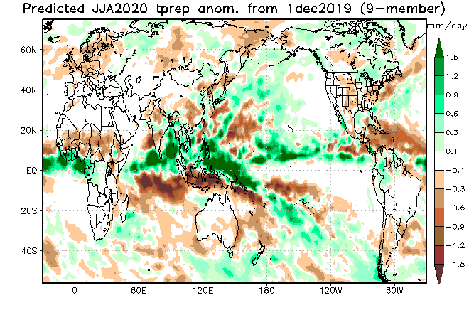 |
| There is a dry belt impacting just north of Equatorial Africa and Southeast Asia and parts of the Northern Maritime Continent become wetter than in the earlier seasons. |
D. Conclusion
We did not do our usual comparison of the Nino 3.4 forecasts this month and that might have been the formula for having more agreement but certainly not for Summer. Even though we did not do a formal comparison of the differences in assumptions between the two agencies, this sentence from the JAMSTEC discussion is revealing.
As predicted earlier, the El Niño Modoki-like state has been observed. The SINTEX-F predicts that a weak El Niño-like pattern (possibly a mixture of Modoki-type and canonical-type) will persist at least until boreal summer of year 2020.


