Written by Sig Silber
U.S. and World Agriculture: Plus an Expanded Weather Forecast Section
Updated at 3:40 PM EDT March 29, 2019 to reflect the updated Week 3 – 4 Forecast which is generally favorable for further drought reduction.
Much to report this week. The Drought has shifted its location and we will go into that. But first we will review the winter weather to see what we can learn. Then later in the report there is a long, now monthly, crop and soil conditions report which is not as positive as we would like. It seems that coming out of drought has also been accompanied by some weather that has not been good for agriculture. And of course we will cover the current condition of the drought plus a forecast and much else.

Please share this article – Go to the very top of the page, right-hand side, for social media buttons.
Drought Shifts

Now we compare the current situation to the situation at the beginning of winter specifically the week ending December 4, 2018,
 |
 |
1. Special Reports, Summary Weather Forecast and Information on how this Report is Organized.

Here is the current status of flooding.

Let’s take a look at last winter that is December through February.
Recently we showed the state rankings for February but these are the state rankings for the full winter season. The way to understand these two graphics is to realize that what is being shown is the ranking of the weather in each state in terms of how it ranked with respect to the 124 year history. That is different than the second set of graphics which will look at the weather in terms of deviation from what is considered current climatology. I decided not to show the absolute numbers graphics or the max and min graphics to avoid providing a data overload. The ranking graphic is very useful in assessing how each state did relative to its own history and also it shows regional patterns.


Now we look at deviations from climatology and keep in mind the definition of climatology changes as it is a 30-year average. This impacts temperature more than precipitation as the secular trend in temperature as well as long cycles such as the AMO and PDO change climatology. So it is somewhat more of a current analysis i.e. comparison with the 30-year average measured as 1981 to 2010.
First Temperature

Then Precipitation.

March Crop and Soil Conditions Report
We left that in the normal position in this report. It is very interesting but long so you can read it there. It is called the March Report but probably only covers up to March 24 as it was issued on March 26 which was prior to the end of March.
Reservoirs and Rivers.
I had planned to provide some updates on reservoirs this week but there is too much else to talk about so we will put that off again until next week except for California. For now, we report on California Reservoirs weekly. We may soon switch to monthly since the California Reservoirs seem to be in good shape for now. The weekly California Reservoir Report is shown later.
Summary Intermediate-Term Weather Forecast (helpful to predict drought and floods etc)
Here is the summary of the forecast for the next approximately twenty-five days. We provide this so that we can make our own assessment of the drought forecast. Here I provide the weather forecasts for different periods of time in which should allow the reader to assess the likelihood of this forecast working out as shown over the next three to four weeks. Since we publish this week on Thursday, we generally update the discussion for the Week 3 – 4 forecast when it is updated on Friday. This is important as the current Day 6 – 14 forecasts and the week-old week 3 – 4 forecast overlap to some extent.
Later we provide additional information relative to the weather forecast analysis but here is the summary.
First the Temperature Forecast.
 |  |  |  |
| This shows magnitude rather than the probability of being higher or lower than Normal and shows the middle day of the five day period. | Looks like there is a gradual warming from Week -1 to Week – 2 especially in the East. But NOAA has backed off to some extent re the impact of an Atlantic High on the East Coast. * warmer or cooler than climatology | ↑ The Week 3 – 4 forecast was issued on March 29. It is favorable for futher drought reduction except for the Northern Tier. ← . | |
And then the Precipitation Forecast
|  |  | |
| The five-day QPF is shown above. The units are different than the other maps i.e. in units of precipitation (inches) not probabilities of exceeding or being less than climatology. | The wet anomaly seems to remain slightly to the north. The forecast is wet but not extremely wet. | ↑ The Week 3 – 4 forecast was issued on March 29. It is favorable for futher drought reduction except for the Northeast. ← | |


Additional Information on the forecast is provided later.
Organization of this Report
This report is now organized as follows:
- Special Reports, Weather Forecast Summary, and information on how this Report is organized. .
- Present Drought Conditions
- Recent Weather
- Selected information from our Weekly Weather Column (the forecast maps auto-update) and combined with brief commentary from me provides a forecast which I attempt to interpret re the likely change in drought conditions. But we will not repeat the forecast summary shown in the introduction as having duplicate information increases the chances of errors during updating.
- Monthly Reports as they become available. (This week it is the Crop Report)
- Science theme if we have one.
- Economic Impacts of Weather other than on Agriculture. It will take time to get that part of the report going.
- Reference Information.
Monthly Reports will include:
- Crop Report (Covered in Section 5)
- Analysis of the Prior Month’s Weather for the U.S.
- Analysis of the Prior Month’s Weather Internationally
- Current Status of Reservoirs and River Flow.
|
| Remember if you leave this page to go to links or if you have clicked to enlarge a graphic, in order to get back you need to hit the return arrow usually located on the left of your URL box on the upper left of the screen. Also most of the small graphics are designed to become full size when you click on them. If that does not work, an alternative way to view the larger graphics is to right click and then hit “view image”. That should always work. |
2. Present Drought Conditions
The U.S. Drought Monitor is a comprehensive way of understanding the drought situation for the U.S. It is issued every Thursday and reflects the conditions as of the prior Tuesday. Drought is defined as a moisture deficit bad enough to have social, environmental or economic effects. Thus, more factors than recent precipitation are considered and more information on how it is done is found at the end of this report.

Below is the same map but just CONUS and with statistics and below that map I have provided a cut-out of the statistics which I think you can click on to enlarge. When you click on graphics that I have set up to enlarge often with your mouse right click and then click on “view image” and that will work.
 |
 |
| Last Week | This Week |
| |

The graphic below shows the one-week change in drought intensity. Yellow is bad. Green is good.
|
We are not showing the change maps for the states that improved the most and deteriorated the most. There are just too many and it is to laborious to create that matrix. You can see them in the regional change maps that we provide. For those interested in a particular state, those maps can be accessed here.
Now we show the week to week change information by region. The yellow is where the drought has been upgraded. The green is where the level of drought has been downgraded.
 |
Better in Nebraska and Colorado. Deterioration in Wyoming. |
 |
| No Change |
 |
| No Change |
 |
Mostly Deterioration in Texas, Oklahoma, Louisiana, MIssissippi |
 |
| Deterioration in Alabama, Florida, Georgia and South Carolina. But this is deterioration from essentially non-drought conditions. |
 |
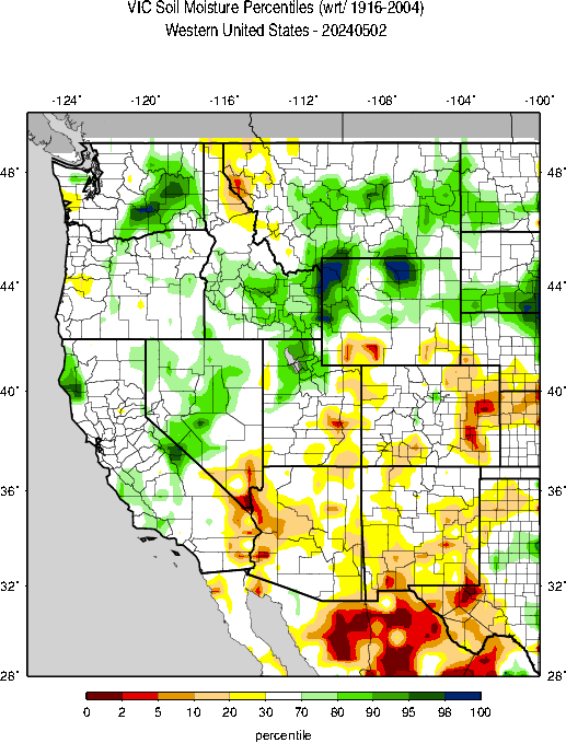
Deterioration in Washington and Wyoming (which shows up on two maps) and improvement in Nevada, Utah, Colorada, Arizona, and New Mexico. |
This pair of maps might make it easier to get a general idea of what is happening in the worst part of the drought area.
| Last Week | This Week |
 |  |
This map which covers the West may be useful also.

Here is one additional approach to thinking about this area.

Some may find this way of looking at things useful and I hope these graphics are not too small to read. I did not make them so you could click on them individually but you can click on the whole graphic and it may enlarge. But I think you get the picture. It has been a rapid onset and demise. When you read these graphics, remember that the older graphics are not the drought conditions that existed then but the change from then until now.

Some might find this animation of twelve weeks of change useful;

Here is the discussion which was issued with the Drought Monitor today.
This Week’s Drought Summary
Dryness and drought intensified across parts of the South, while the overall trend toward drought recovery continued in the Four Corners region. Elsewhere, dryness concerns increased in the Northwest where drought expanded slightly; rain and snow will be needed soon across the northwestern quarter of the nation to prevent the region from slipping further into drought. Most of the nation from the central and northern Plains to the Mid-Atlantic and Northeast remained free of drought, with severe flooding the primary concern in the nation’s heartland.
Northeast
Cooler-than-normal weather with heavy rain and mountain snow were reported across the region, with 7-day precipitation topping 3 inches over Maryland and southern Pennsylvania. There are no areas of Abnormal Dryness (D0) or drought in the Northeast.
Southeast
The recent and pending rain in southern and eastern portions of the region fell after the Tuesday morning data cutoff and will be included in next week’s assessment. During the monitoring period, heavy rain in northern portions of the region contrasted with intensifying dryness in drought farther south. Rain totaled 1 to 3 inches from central and eastern North Carolina into northern Virginia, with reports topping 3 inches west of the nation’s capital. Likewise in eastern Florida, locally heavy showers (1-3 inches) near Cape Canaveral led to a small reduction of the state’s eastern Abnormal Dryness (D0); the rest of Florida’s coastal D0 was still wrestling with notable deficits over the past 9 months (50-70 percent of normal). Meanwhile, D0 and D1 (Moderate Drought) were expanded from the northeastern Gulf Coast into the southern half of South Carolina. Rainfall over the past 60 days has totaled a meager 30 to 50 percent of normal in the aforementioned areas, locally less than 30 percent from east-central Georgia to the South Carolina Coast. Impacts are still relatively minor, though streamflows have dropped below the 10th percentile in the driest locales.
South
Rain in the north contrasted with intensifying dryness in southern portions of the region. Moderate to heavy showers (1-2 inches, locally more) were noted from northern Texas and western Oklahoma southeastward into the northern and central Delta, resulting in a slight reduction of the northern Texas Abnormal Dryness (D0). Additional reductions to the southern Plains’ D0 were made based on input from local experts, indicating additional benefits from the previous week’s rainfall. Conversely, increasingly dry conditions in Texas have been noted over the past 60 days from Childress southward toward Laredo and Corpus Christi, with 90-day rainfall tallying a meager 20 percent of normal in the state’s expanded Severe Drought (D2) areas. Farther east, a highly variable signal is evident from Austin, Texas, eastward to New Orleans, Louisiana; 90-day rainfall has averaged near to above normal in these locales, while 60-day precipitation was below half of normal (locally less than 30 percent).
Midwest
The Midwest remained free of drought, with significant flooding impacting the Mississippi River and its tributaries.
High Plains
The primary concern on the High Plains centered on locally severe flooding in the Missouri River Basin, though localized dryness intensified in some western locales. Moderate to heavy rain (1-2 inches) eliminated the lingering pockets of Abnormal Dryness (D0) in northeastern Colorado and western Nebraska, while a continuation of wet weather (0.5-1 inch) in east-central Colorado facilitated the reduction of D0 east of Colorado Springs. Meanwhile, another round of moderate to heavy snow across central and western Colorado pushed mountain snowpack Snow Water Equivalents (SWE) to record or near-record levels (approaching or reaching the 100th percentile); as a result, additional reductions to the lingering long-term D0 and Moderate Drought (D1) were made. Note the drought over much of the Four Corners is almost exclusively now long-term (L) drought, with deficits most pronounced at 24 months (50-80 percent of normal) and beyond. Despite the overall trend toward drought removal on the High Plains, pronounced short-term dryness over the past 60 days (20-50 percent of normal) east of the Bighorn Mountains led to a small increase in D0 in north-central Wyoming.
West
Increasingly dry conditions in the Northwest contrasted with additional recovery from long-term drought from the Great Basin into the central and southern Rockies.
Across central and southern portions of the region, moderate to heavy precipitation (0.5 to more than 1 inch) fell from Nevada east-southeastward into Colorado and northeastern New Mexico. This week’s precipitation – on top of last week’s rain and snow – as well as input from local experts led to widespread reduction of the southern High Plains’ Abnormal Dryness (D0). Across northern New Mexico and southern Colorado, precipitation over the past two weeks has totaled an impressive 1 to 5 inches (liquid equivalent), pushing mountain Snow Water Equivalents (SWE) toward record levels (80-100th percentile) and begetting notable reductions in drought intensity and coverage. Similar SWE were reported across Utah and Nevada, with corresponding decreases to the lingering D0 and Moderate Drought (D1). Note the drought over much of the Four Corners is almost exclusively now long-term (L), with deficits most pronounced at 24 months (50-80 percent of normal) and beyond.
Farther north, a drought-free California contrasted with increasingly dry conditions across the Northwest and northern Rockies. Changes to the Northwestern drought depiction were minor and confined to small increases of D0 and D1 in northern and western Washington. However, local experts are becoming concerned as water-year precipitation (70-80 percent of-normal) has been subpar in the central and northern Cascade Range and environs, exacerbated by acute short-term dryness (60-day precipitation totaling 30 to 50 percent of normal in Washington, slightly more in northwestern Oregon). Furthermore, snowpacks remained much lower than those seen farther south, with SWE in the 10th to 30th percentile over much of Washington, northern Idaho, and western Montana.
Alaska, Hawaii, and Puerto Rico
Drought conditions were unchanged in Alaska. While snowpacks remained unfavorably low on the Kenai Peninsula (Snow Water Equivalents (SWE) at or below the 25th percentile), this has been largely due to warmth; water-year precipitation has been near to above normal in these same locales. In southeastern Alaska, acute short-term dryness is raising the specter of intensifying drought, with 60-day precipitation averaging 50 percent of normal or less in the state’s Severe Drought (D2) areas. In Hawaii, acute dryness in March following a wet February led to widespread expansion of D0. In particular, 30-day rainfall deficits of 2 to 5 inches (2-33 percent of normal) are common across the islands from Kauai to Hawaii. Conversely, showers increased on Puerto Rico, though rain was not yet sufficient to cut into the Abnormal Dryness (D0) and Moderate Drought (D1).
Looking Ahead
An unsettled weather pattern will continue over much of the nation. A pair of Pacific storms are expected to bring much-needed rain and mountain snow to the Northwest and northern Rockies. As the lead system marches east, it will produce rain and snow from the central Plains into the Midwest, though the Upper Midwest will remain dry. Increasingly stormy weather is also in the offing for the East Coast States, with the greatest chances for heavy rain noted along Florida’s eastern coast and from the Carolinas into the Mid-Atlantic region. Mostly dry weather is expected from the lower Four Corners into central Texas, while showers may return to southern Texas. The NWS 6- to 10-day outlook for April 2 – 6 calls for near- to above-normal precipitation across most of nation, save for pockets of dryness in the Southwest and central Gulf Coast region; drier-than-normal conditions are also expected over Alaska. Colder-than-normal weather over northern portions of the Plains and Upper Midwest will contrast with above-normal temperatures in northern- and southern-most portions of the Atlantic Coast States and from the Four Corners into the Northwest and Alaska.
Here is part of the explanation for the overall situation in the West. Looking at the information from the network of SNOTEL sites. These are mainly in remote locations often at high elevations. they report by telecommunications hence their name.


Then we look at how much snow there is to melt when it is warmer.

Soil Conditions
|

| And looking at the West. |
|
Wildfires are still possible.


3. Recent Weather
The cold temperatures has had a negative impact on a number of different crops. But snow can protect certain crops.

This is more current but less informative.
 This
This
Here is the SWE (water content of the snow) version.

Last Seven Days
For reference purposes here is the precipitation information for the prior seven days. It is not the same as what is shown in the USDA Crop Report since the crop week covers the Sunday to Saturday period which corresponds to the crop reports. But I have not included in this article the weather graphics that correspond to the crop week. I think it may have created confusion.
Below is the current seven-day period and updates in this article automatically every day. It is a better tool for making forecasts.


Current Month to Date.

And then temperature

You can generate a wide variety of different graphics here.
4. Current Forecast for Precipitation and Drought.
First, we show the current month forecast. Sometimes we show them in more than one place in this report for the convenience of the reader.
And here is the March one-month drought forecast which was issued on February 28, 2019. It will be updated on March 31, 2019.

Here is the Seasonal Forecast through May 31 which was issued on March 21, 2019 with the full Seasonal Outlook. These two forecasts are issued by the same agency but to obtain them you need to access two different links here and here. The three-month Seasonal Drought Outlook will be updated on April 18, 2019.

We provided the summary approximately 25 Day Forecast earlier. Here is additional information that relates to this forecast.
First weather hazards


Additional information can be obtained here. We also now publish a Live Severe Weather article. The link to our Severe Weather Events article changes every Sunday night and the current version can always be found in the Directory which can be accessed here.
And we do not want to ignore floods. The updated map can be obtained here.
Let’s see if this animation works.

Here are additional useful graphics from my weekly report which update automatically. The forecast maps were shown in the Introduction.
First the Day 3 Mid-Atmosphere pattern.


The below is of interest.

5. New Reports
 |
 |
 |
 |
 |
 |
 |
 |
Reservoir Conditions


The sequence of drought occurrence and impacts for commonly accepted drought types. All droughts originate from a deficiency of precipitation or meteorological drought but other types of drought and impacts cascade from this deficiency. (Source: NDMC)
Source: National Drought Mitigation Center, University of Nebraska-Lincoln


