Written by Sig Silber
U.S. and World Agriculture: Plus an Expanded Weather Forecast Section
Updated at 4:30 p.m. EST March 15 to reflect the new Week 3 – 4 forecast which if confirmed by actuals will eliminate the remnant Four Corners Drought.
The intensity of the drought declined again this past week. The storms that have reduced the drought are now the negative for the U.S. economy both in terms of flooding and a cold start to the growing season. From the discussion in the Drought Monitor today:
Following the wettest winter (December-February) on record for the contiguous U.S. as a whole, storms continued to bring heavy rain and snow, piling on snowpack and filling reservoirs in the West, but also causing avalanches in Colorado.

Please share this article – Go to very top of page, right hand side, for social media buttons.
Our article this week presents a lot of information on the Month of February. And of course we provide our regular coverage on the recent weather, the short and intermediate term forecast, and a short International report. We also provide update maps for some key rivers. There is a lot of information in this report including the montly update on the status of ENSO.
1. Special Reports, Summary Weather Forecast and Information on how this Report is Organized.
First some highlights from last week.
But even before that the current situation.

And flooding is certainly worse…this graphic is repeated later in the article

Then back to the new information releases.
The data is in on state rankings re Temperature and Precipitation.
First Temperature

I should have the state rankings for the winter season next week not just for the month of February. But until then this might pique your interest.
Winter Weather: I was not planning to show this but it was unusual enough that it needs to be shown.


Now looking at Precipitation

The sort of might be El Nino is expected to continue.

Take your pick of the red, blue, and green lines…I do not understand the difference but they all say the same thing.
Here is the text that accompanies the report.
EL NIÑO/SOUTHERN OSCILLATION (ENSO) DIAGNOSTIC DISCUSSION
issued by
CLIMATE PREDICTION CENTER/NCEP/NWS and the International Research Institute for Climate and Society 14 March 2019
ENSO Alert System Status: El Niño Advisory [Editor’s Note: This is no change from the report last month]
Synopsis: Weak El Niño conditions are likely to continue through the Northern Hemisphere spring 2019 (~80% chance) and summer (~60% chance).
El Niño conditions strengthened during February 2019, as above-average sea surface temperatures (SSTs) increased across the equatorial Pacific Ocean and the associated atmospheric anomalies became increasingly well-defined. The SST index values in the Niño3, Niño3.4 and Niño4 regions all increased during February, with the latest weekly values near +1°C in each region. The anomalous upper-ocean heat content (averaged across 180°-100°W) increased appreciably during February, due to an increase in above-average temperatures at depth in association with a downwelling equatorial oceanic Kelvin wave. Enhanced equatorial convection prevailed near the Date Line, while suppressed convection was observed over Indonesia. Low-level wind anomalies were westerly in the central Pacific Ocean, while upper-level wind anomalies were mostly westerly over the far western and far eastern Pacific. The equatorial and traditional Southern Oscillation Index values were both negative (-1.4 standard deviations). Overall, these features are consistent with weak El Niño conditions.
The majority of models in the IRI/CPC plume predict a Niño 3.4 index of +0.5°C or greater through the Northern Hemisphere early autumn 2019. Given the recent downwelling Kelvin wave, and the increase in both the SSTs and subsurface ocean temperatures, most forecasters expect positive SST anomalies to persist across the central and eastern Pacific for at least the next several months. During that time, forecasters predict the SST anomalies in the Niño 3.4 region to remain between +0.5°C and +1.0°C, indicating weak El Niño conditions. However, because forecasts made during spring tend to be less accurate, the predicted chance that El Niño will persist beyond summer is currently about 50%. In summary, weak El Niño conditions are likely to continue through the Northern Hemisphere spring 2019 (~80% chance) and summer (~60% chance); click CPC/IRI consensus forecast for the chance of each outcome for each 3-month period.
This discussion is a consolidated effort of the National Oceanic and Atmospheric Administration (NOAA), NOAA’s National Weather Service, and their funded institutions. Oceanic and atmospheric conditions are updated weekly on the Climate Prediction Center web site (El Niño/La Niña Current Conditions and Expert Discussions). Forecasts are also updated monthly in the Forecast Forum of CPC’s Climate Diagnostics Bulletin. Additional perspectives and analysis are also available in an ENSO blog. The next ENSO Diagnostics Discussion is scheduled for 11 April 2019. To receive an e-mail notification when the monthly ENSO Diagnostic Discussions are released, please send an e-mail message to: [email protected].
Climate Prediction Center National Centers for Environmental Prediction NOAA/National Weather Service College Park, MD 20740
River flows are improving.


Next week we will provide some updates on reservoirs.
But for now we report on California Reservoirs weekly.

Perhaps I should wait for the monthly crop production data but this came in so I will report it.

Here is the forecast for the next two weeks.
Later we provide additional information relative to the weather forecast analysis but here is the summary.
First the Temperature Forecast .
 |  |  |  |
| This shows magnitude rather than probability of being higher or lower than Normal and shows the middle day of the five day period. | Looks like the Eastern cool anomaly will finally be eliminated. There is a new Southwest cool anomaly forming. * warmer or cooler than climatology | ↑ The Week 3 – 4 forecast was issued on March 15. The warm anomaly is not good relative to drought and could be a problem in the Northwest. ← . | |
And then the Precipitation Forecast
|  |  | |
| The five day QPF is shown above. The units are different than the other maps i.e. in units of precipitation (inches) not probabilities of exceeding or being less than climatology. | It starts (days 6 – 10) wet in the Southwest and the wet anomaly gradually expands east. | ↑ The Week 3 – 4 forecast was issued on March 15. If the precipitation forecast is confirmed by actuals, the Four Corners Drought will be gone within four weeks. The Northern Tier dry anomaly is not good news for the Northwest. ← | |


Additional Information on the forecast is provided later.
Organization of this Report
This report is now organized as follows:
- Special Reports, Weather Forecast Summary and information on how this Report is organized. .
- Present Drought Conditions
- Last Week’s Weather
- Selected information from our Weekly Weather Column (the forecast maps auto-update) and combined with brief commentary from me provides a forecast which I attempt to interpret re the likely change in drought conditions. But we will not repeat the forecast summary shown in the introduction as having duplicate information increases the chances of errors during updating.
- Monthly Reports as they become available.
- Science theme if we have one.
- Economic Impacts of Weather other than on Agriculture. (it will take time to get that part of the report going.
- Reference Information.
Monthly Reports will include:
- Crop Report
- Analysis of the Prior Month’s Weather for the U.S..
- Analysis of the Prior Month’s Weather Internationally
- Current Status of Reservoirs and River Flow.
|
| Remember if you leave this page to go to links or if you have clicked to enlarge a graphic, in order to get back you need to hit the return arrow usually located on the left of your URL box on the upper left of the screen. Also most of the small graphics are designed to become full size when you click on them. If that does not work, an alternative way to view the larger graphics is to right click and then hit “view image”. That should always work. |
2. Present Drought Conditions
The U.S. Drought Monitor is a comprehensive way of understanding the drought situation for the U.S. It is issued every Thursday and reflects the conditions as of the prior Tuesday. Drought is defined as a moisture deficit bad enough to have social, environmental or economic effects. Thus, more factors than recent precipitation are considered and more information on how it is done is found at the end of this report.

Below is the same map but just CONUS and with statistics and below that map I have provided a cut-out of the statistics which I think you can click on to enlarge.
 |
 |
| Last Week | This Week |
| |

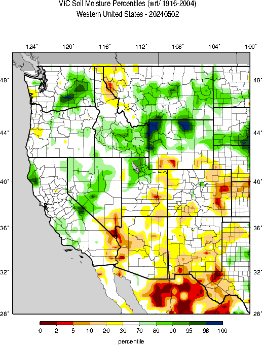
The graphic below shows the one-week change in drought intensity. Yellow is bad. Green is good.
 |
We are showing the change maps for the states that improved the most and deteriorated the most.
 |  |  |
 |  |  |
|  |  |
 |  |  |
 |  |

This pair of maps might make it easier to get a general idea of what is happening in the worst part of the drought area.
| Last Week | This Week |
 |  |
Here is one approach to thinking about this area.


This map which covers the West may be useful also.

Here is part of the explanation for the overall situation in the West. Looking at the information from the network of SNOTEL sites. These are mainly in remote locations often at high elevations. they report by telecommunications hence their name.


Then we look at how much snow there is to melt when it is warmer.

Now we show the week to week change information by region. The yellow is where the drought has been upgraded. The green is where the level of drought has been downgraded.
 |
Better in Wyoming and Colorado |
 |
| No Change |
 |
| No Change |
 |
Mostly improvement in Texas. Some improvement in Oklahoma…left out the Oklahoma map in the state map matrix…sorry about that. |
 |
| Deterioration in Georgia and also South Carolina and also Mississippi which I did not include in the map matrix…sorry about that. |
 |
Changes in many states. For all of these states we provided individual maps earlier. Those maps will enlarge when clicked on this week. |
Some may find this way of looking at things useful and I hope these graphics are not too small to read. I did not make them so you could click on them individually but you can click on the whole graphic and it may enlarge. But I think you get the picture. It has been a rapid onset and hopefully it’s demise will also be fairly rapid. When you read these graphics remember that the older graphics are not the drought conditions that existed then but the change from then until now.

Some might find this animation of twelve weeks of change useful;

Here is the discussion which was issued with the Drought Monitor today.
This Week’s Drought Summary
As spring nears, winter has kept its grip over much of the country. Temperatures were below average across the contiguous U.S, up to 25 degrees below normal for the week in the North. Following the wettest winter (December-February) on record for the contiguous U.S. as a whole, storms continued to bring heavy rain and snow, piling on snowpack and filling reservoirs in the West, but also causing avalanches in Colorado. Generally, heavy snow fell across high elevations in California, the Rockies into the Upper Great Lakes and Mid-Mississippi Valley, with heavy rain across parts of Southern California and the Tennessee Valley. The abundant precipitation in the West led to more widespread drought improvement. Little to no precipitation fell across the southern tier of the U.S., continuing a pattern of below-average rainfall seen over the last 2-3 months in parts of the Southeast, as dry conditions begin to emerge.
Northeast
Temperatures for the most part were 5-15 degrees F below average across the region over the past week. While some areas continued to see heavier (and much heavier) than normal precipitation, several large areas, from northeastern Pennsylvania and much of New York to Connecticut, Massachusetts, New Hampshire, and Vermont received less than their typical amounts for this time of year. Even so, conditions overall remain good and the Northeast continues to remain drought-free.
Southeast
Temperatures were about 5-10 degrees F below average across the region, and precipitation was below average in many areas, particularly notable in the far southern areas. Rainfall deficits are beginning to build in some areas. As such, abnormal dryness (D0) was expanded into southeastern Georgia and introduced to a couple of localized areas in southern and southeastern Alabama.
South
Drought-free conditions continued across most of the South. Western Oklahoma and northern and western Texas received rainfall late in the drought week that allowed some retreat of both moderate drought (D1) and abnormal dryness (D0). South central and southern Texas received little to no precipitation and D0 conditions expanded slightly eastward.
Midwest
Every state in the Midwest received above-average to much-above-average precipitation during the meteorological winter season (December to February), leaving the area with deep snowpack and overall wet conditions. With temperatures around 10 to 20+ degrees F below average over the past week, the entire region remains free of drought and dryness.
High Plains
Most areas of the High Plains were free of drought or saw little change in current status, the exception being Colorado, where heavy snow continued to build snowpack but also caused avalanches. With well-above average precipitation in February and adequate precipitation in March to date, improvements were made across the Yampa/White Basin. The Gunnison Basin, already well past its normal seasonal peak, received an additional 2-4 inches of precipitation over the last week. Severe drought (D2) improved to moderate (D1) over the San Juan Basin east through the San Luis Valley, where the San Juans have received well-above-average precipitation and basin-wide snowpack is already past the normal seasonal peak. North central Colorado into Carbon County, Wyoming saw as much as 2-category drought improvement to return to drought-free conditions. In this region reservoirs are expected to fill and there is deep snow, unfortunately with problematic avalanches.
West
Well-above-average precipitation continues in the West, improving long-term soil moisture deficits, building snow pack, and filling reservoirs, therefore leading to more widespread drought improvement. Areas of western Utah received up to double their typical precipitation in the last month, improving conditions across the region. From northern California into Oregon and Idaho, snowpack continues to build at mid and high elevations, compensating for long-term dry soil moistures. Reservoirs have also continued to fill. Improvements were made across this region, including a vast reduction in severe drought (D2) in Oregon and a return to normal conditions across most of Idaho and northern Nevada. Idaho’s central mountains received more snowfall in February than the previous three months combined. Snow there continued to accumulate, with continuing colder-than-normal temperatures. As such, no irrigation issues are anticipated and water supplies are expected to be adequate. Dry conditions also improved to normal to the north across parts of eastern Washington, northern Idaho, and northwestern Montana. Precipitation in recent months, including for the water year to-date, has been above average and enough to erase long-term impacts. In the Southwest, improvements were seen along the Mogollon Rim and White Mountains of eastern Arizona. Many of the lakes are full and spilling, and snow remains to melt in the higher elevations. Normal conditions also returned to most of southwestern Arizona to the Salton Sea in southeastern California. The rest of the region in Southern California is still abnormally dry due to very dry previous years. Reservoirs in San Diego County are only at 65% capacity. Big Bear Lake was down 18 feet in early March, although expected to continue to rise.
Alaska, Hawaii, and Puerto Rico
Hawaii has seen fairly consistent rainfall along the east facing slopes of the islands and drier conditions over leeward areas. Following wet conditions in February, areas that were experiencing abnormal dryness on the Big Island and Maui continue to recover well. Abnormally dry (D0) conditions improved to normal across both islands this week.
Puerto Rico also saw adequate precipitation over the past week to relieve some moderate drought (D1) and abnormally dry areas that had been building in the southern coastal region and southwest.
Looking Ahead
The central U.S. is anticipating a very strong storm from the12th to the 14th, with the threat of blizzard conditions from the Rockies to the Central and Northern Plains to the Upper Midwest, and severe storms with hurricane-force winds from the Southern Plains to the Mid-Mississippi River Valley. Heavy rains in the Midwest and Great Plains may melt snow that lead to significant flooding. The storm is expected to impact 70 million people. Looking further out into the next week, much of the nation may see dry, cool weather, with below-average temperatures and below-average precipitation forecast across most of the eastern half of contiguous U.S. Looking two weeks ahead, increased chances of above-normal precipitation are forecast for Alaska, the southern Florida Peninsula, and the western half of the contiguous U.S. The eastern half, on the other hand, is forecast to continue seeing drier-than-normal conditions.

Soil Conditions
|

| And looking at the West. |
|
Wildfires are still possible. But the risk is not high right now.


Let’s see if this animation works.

3. Last Week’s Weather
Avoiding date confusion: The Agriculture Bulletin is issued on a Tuesday and overs a-seven day period that ends on Saturday and some others on Sunday – some graphics have Saturday as the end date and others Sunday. The Drought Monitor is issued on a Thursday and shows conditions as of Tuesday of that week. So we have two sets of weather maps. On set is synchronized with the Crop Bulletin Report and the others are updated daily so we may have two sets of maps that describe the prior week. In one case it is the crop week and in the other case it is the week before the article is read. So please do not be confused. Most of these maps show the days covered.
These graphics apply to the crop week. They are frozen and do not auto-update.


This is more current but less informative.
 This
This
Here is the SWE (water content of the snow) version.

Last Seven Days
For reference purposes here is the precipitation information for the prior seven days. It is not the same as what is shown in the USDA Crop Report show above since the crop week covers the Sunday to Saturday period which corresponds to the crop reports. The below is the current seven-day period and updates in this article automatically every day. It is a better tool for making forecasts.


Current Month to Date.

And then temperature

You can generate a wide variety of different graphics here.
4. Current Forecast for Precipitation and Drought.
First we show the Seasonal Forecast through May 31 which was issued on February 21, 2019 with the full Seasonal Outlook. These two forecasts are issued by the same agency but to obtain them you need to access two different links here and here. We either show the latest or both in this report. Sometimes we show them in more than one place in this report for the convenience of the reader.
The three-month Drought Outlook will be updated on March 21, 2019.

And here is the March one-month drought forecast which was issued on February 28, 2019. It will update on March 31, 2019.

And now the current precipitation forecasts so that we can make our own assessment of the drought forecast. Here I provide the weather forecasts for different periods of time in which should allow the reader to assess the likelihood of this forecast working out as shown over the next three to four weeks. Since we publish this week on Thursday, we generally update the discussion for the Week 3 – 4 forecast when it is updated on Friday. This is important as the current Day 6 – 14 forecasts and the week-old week 3 – 4 forecast overlap to some extent. But since this week, we are publishing on Friday, no update will be required.
First weather hazards


Additional information can be obtained here. We also now publish a Live Severe Weather article. The link to our Severe Weather Events article changes every Sunday night and the current version can always be found in the Directory which can be accessed here.
And we do not want to ignore floods. The updated map can be obtained here.
Here are additional useful graphics from my weekly report which update automatically. The forecast maps were shown in the Introduction.
First the Day 3 Mid-Atmosphere pattern.


The below is of interest.

Review of Month of February Weather.


Winter Weather: I was not planning to show this but it was unusual enough that it needs to be shown.


Sequence of drought occurrence and impacts for commonly accepted drought types. All droughts originate from a deficiency of precipitation or meteorological drought but other types of drought and impacts cascade from this deficiency. (Source: NDMC)
Source: National Drought Mitigation Center, University of Nebraska-Lincoln


