Written by Sig Silber
Updated at 3 p.m. EST March 14, 2019 to reflect the updated map for convection related risk of severe weather.
This article provides continuous updates for a variety of Weather and Weather Related Threats. Please pay attention to smaller maps – these are “Live” and NOAA “Headline” areas are shown when posted. Pay attention to where you live or travel. Click maps for details.
Focus Points this Week: The short-term situation is most concerning. The first map shown is the key.

Please share this article – Go to very top of page, right-hand side for social media buttons.High
Current Highlights

Excerpts from latest forecast. One can get the latest by WPC forecast by clicking here.
Valid 12Z Thu Mar 14 2019 – 12Z Sat Mar 16 2019
…The strong winter storm to continue to affect portions of the Central to Northern Plains today with Blizzard conditions continuing…
…Winds will be diminishing across the Southern and Central Plains as the storm pulls away from these regions…
…Thunderstorms will bring heavy rains, isolated flooding and a severe weather threat Thursday from the Lower Mississippi Valley into the Tennessee and Ohio Valleys…
…Much above average temperatures likely east of the Mississippi River Thursday, across the eastern U.S. Friday…
…Much colder temperatures will spreading into the Mississippi, Tennessee and Ohio Valleys Friday and the east coast on Saturday…
Of most current concern
 |
This should update and you should be able to click on to get additional details but if it does not update and you can not click on it, click here.
Here is a larger version that does not update nor is able to be clicked on but is easier to read. You can tell from the time stamp in the lede paragraph if this map is up to date and if not, just click on the above map and you will get an up-to-date version of the larger map and much more. It is here just for convenience but I cannot update it every six hours as the above map updates.

The following is provided to help the reader relate the maps to how NWS will describe an area of the U.S.

We will pay special attention to severe convection events including tornadoes as we are entering that time of the year and the temperature gradients create instability. Active Jet Stream adds to the risks.
A useful read…the STP index. Click Here. Enhanced Tornado Intensity Scale Explained Here.
Zulu to Local Time Converter(click here) …Necessary because NOAA uses Universal Time also called ZULU or Z and Legislators all over the place are doing their best to get everyone confused. You need to know if you are on Standard Time or Daylight Savings Time to figure it out correctly.
Now to our Regular Report
You will see a number of different maps which are updated in real time, making this a “live” report. If a part of one or more of the maps show an area that is highlighted, you can click on it and get the full current report. By having the reader click on these active situations rather than having GEI do so, you will not miss any events in which you might have an interest and which we had not noticed and the page will not get cluttered with warnings etc that have since expired.
Our focus here are events that are likely to last in the range of six hours but there can be longer or shorter events that are addressed by the Storm Prediction Center which is the main source of the information in this article.. Long-term major events like a Hurricane are more likely to be in a separate article. But that may not always be the case. Since in general, all the links on this page transfer you into the NOAA system, in order to get back into this article you need to either close the tab to which you were transferred or click back on the tab that has this article.
Overview: The next two maps provide Information but are not set up to provide more detail (since it is a forecast). It generally updates daily but not on the weekend. So I may update the focus points on Monday and again later in the week as appropriate. Many of the maps later in this report can be clicked on to get detail on specific events that are happening RIGHT NOW! The links at the end of the article will take you to all outstanding watches and warnings.


| Day 3 Maximum Temperature | Five Day Cumulative Precipitation |
 |  |
And Now the Day One and Two CONUS Forecasts: These Maps Update Daily.
Day One CONUS Forecast | Day Two CONUS Forecast |
|
|
These graphics update and can be clicked on to enlarge. You can see where the snow will be. | |
 | |


include (“/home4/aleta/public_html/pages/weather/modules/500_Millibar_by_Day_Matrix.htm”); ?>
This graphic is about Atmospheric Rivers i.e. thick concentrated movements of water moisture. More explanation on Atmospheric Rivers can be found by clicking here or if you want more theoretical information by clicking here. The idea is that we have now concluded that moisture often moves via narrow but deep channels in the atmosphere (especially when the source of the moisture is over water) rather than being very spread out. This raises the potential for extreme precipitation events.


We thought we would show Europe also.

Here are the precipitation forecasts. First the cumulative for Days 1 – 3

Then cumulative for Days 1 – 7

| We now have a special snow report followed by more NOAA severe weather alert maps. | |
|---|---|
You need to click on the graphic above twice. Once to get to the NOAA site and another time to pick the region of interest. Below is the snow levels at the time we went to press. That does not update but you can get the current levels (Nationally and by Region) by clicking the graphic above twice. Below, the static map of current levels at the time we went to press are forecast maps that update related to new snow. | |
 | |
| There is a lot of snow in the West. This map does not auto-update but the graphic above it can be clicked on to get the latest maps with much more information. The below graphic does auto-update. | |
 | |
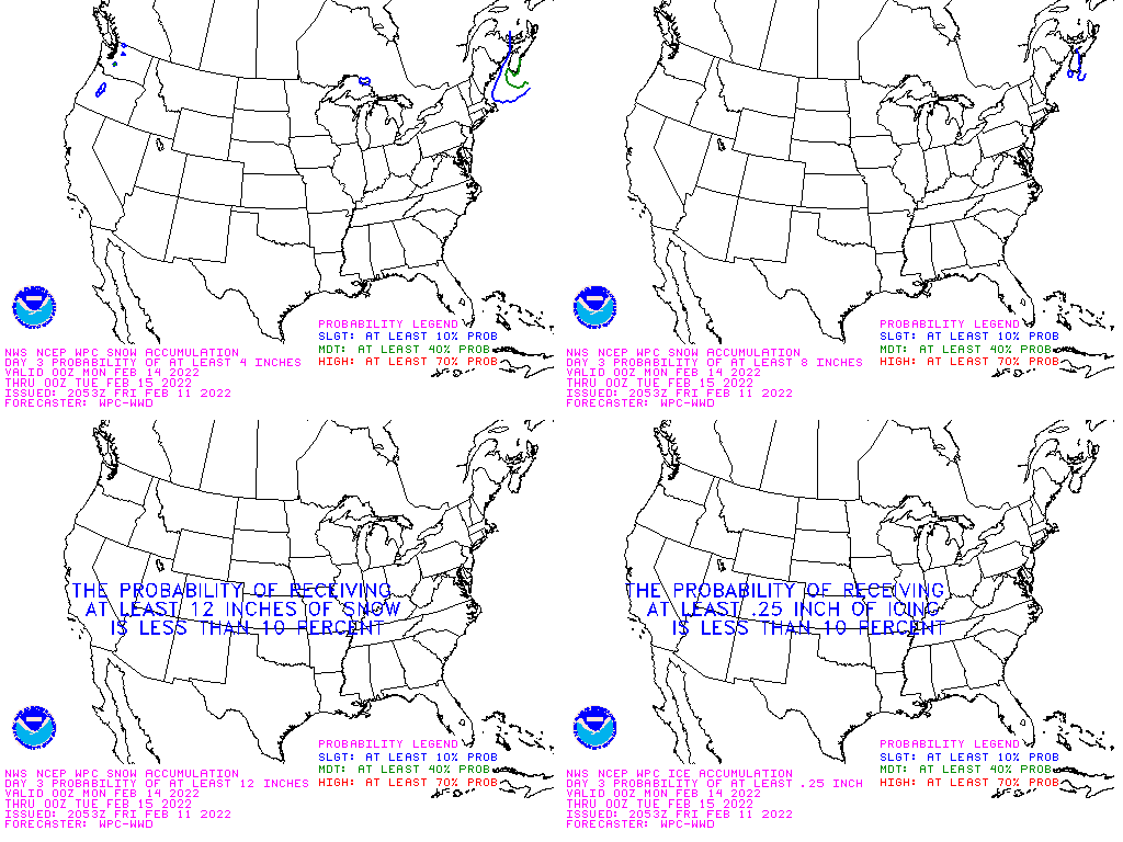
| Above Day I forecast for 4 inches or more snow. Below Day 3 composite forecast for having 4, 8, or 12 inches of new snow during the next 72 hours (possibly good for skiers) and a forecast for where there may be 1/4 inch of ice (travel risk). | |
 | |
| Live Warning Maps which If Severe Weather is Shown can be Clicked on to get more detail about these events. If there is a current warning shown on the map, click on the map for additional information related to the event. | These maps are updated as risks are identified. |
| This is the current graphic showing any mesoscale discussions (MD’s) which are in effect over the contiguous United States. Please read the description of the purpose of our MD’s for further information. Details on all valid MD’s may be found on our Current Mesoscale Discussions page. |  |
| Convective Outlooks (We have plans to add larger maps but you should be able to see the area to click on with the current small maps) | |
| This is today’s forecast for organized severe thunderstorms over the contiguous United States. Please read the description of the risk categories for further information. You may find the latest Day 1 Outlook available as well as all Outlooks issued today online. | Today’s Outlook |
| |
| This is tomorrow’s forecast for organized severe thunderstorms over the contiguous United States. Please read the description of the risk categories for further information. The latest Day 2 Outlook is available as well as all Outlooks that have been issued today. | Tomorrow’s Outlook |
 | |
| This is the day after tomorrow’s (day 3) forecast for organized severe thunderstorms over the contiguous United States. Please read the description of the risk categories for further information. The latest Day 3 Outlook is available as well as all Outlooks that have been issued today. | Day 3 Outlook |
 | |
| This is the day 4-8 forecast for organized severe thunderstorms over the contiguous United States. The latest Day 4-8 Outlook is available as well as all Outlooks that have been issued today. Note: A severe weather area depicted in the Day 4-8 period indicates a 30% or higher probability for severe thunderstorms (e.g. a 30% chance that a severe thunderstorm will occur within 25 miles of any point). | Day 4-8 Outlook |
 | |
| The Thunderstorm Outlooks depict the probability of thunderstorm across the contiguous United States in 4 or 8 hour time periods. The probabilistic forecast directly expresses the best estimate of a thunderstorm occurring within 12 miles of a point. The three probabilistic forecast thresholds are: 10, 40, and 70 percent. | Thunderstorm Outlook |
 | |
| Fire Weather Outlooks | |
| This is today’s forecast for organized wildfires over the contiguous United States. Please read the description of the risk categories for further information about this product. | Today’s Outlook |
 | |
| This is tomorrow’s forecast for organized wildfires over the contiguous United States. Please read the description of the risk categories for further information about this product. | Tomorrow’s Outlook |
 | |
| This is day 3-8 forecast for organized wildfires over the contiguous United States. Please read the description of the risk categories for further information about this product. | Day 3-8 Outlook |
 | |

| Current watches, warnings and advisories issued by the agencies of the National Weather Service. Hazards should show up in the above maps but the below links will take you to all outstanding watches and warnings in each category which may include some categories not covered in the above maps. So if there is a category of interest, click on the appropriate link below. |
|


