Written by Sig Silber
Because we have two active storms likely to impact CONUS this week, one potentially very significant and the other possibly with flash flood risks, plus there being another storm in the Indian Ocean, we have initiated this report so that updates can be provided as the threats become better defined. This avoids readers having to reread the full weather report we publish on Monday nights to find the latest information. There are additional storm possibilities that might develop but it is the ones that we know about that need to be tracked at this point in time.

Please share this article – Go to very top of page, right hand side for social media buttons.
Below is an analysis of projected tropical hazards and benefits over an approximately two-week period.

* Moderate Confidence that the indicated anomaly will be in the upper or lower third of the historical range as indicated in the Legend.** High Confidence that the indicated anomaly will be in the upper or lower third of the historical range as indicated in the Legend.
Tropical Activity (For the Atlantic and Eastern Pacific the key information source right now is the National Hurricane Center )
Atlantic

Of immediate concern

Tropical Storm Michael Discussion Number 6 NWS National Hurricane Center Miami FL AL142018 1000 PM CDT Sun Oct 07 2018
On the last outbound leg to the north, the Air Force Reserve reconnaissance aircraft measured a peak 925-mb flight-level wind of 60 kt and an SFMR surface wind of 53 kt in very light rain. Since that time, deep convection has developed in the same area where those peak wind values were measured, so the initial intensity has been increased to a conservative 50 kt. Another recon aircraft is scheduled to investigate Michael around 0600 UTC.
The initial motion estimate is northward, or 005/03 kt based on the recon and microwave satellite data. The bulk of the forecast rationale remains unchanged, although there remains some notable differences between the models that will ultimately determine where and when Michael will make landfall in about 72 h or so. The GFS, ECMWF, HWRF, and HMON models are tightly clustered along the western side of the guidance envelope. In contrast, the UKMET model is the farthest east of the dynamical models. Interestingly, the NOAA corrected-consensus HCCA model and the simple consensus IVCN models are close to each other and lie between the aforementioned model track dichotomy. Given that modest westerly vertical wind shear is expected to affect Michael throughout the forecast period until landfall occurs, which should keep the strongest convection, associated latent heat release, and pressure falls occurring in the eastern semicircle, the official forecast track leans more toward the HCCA/IVCN and UKMET model solutions. As a result, a slight eastward shift to the previous forecast track was made on this advisory through 48 hours, with little change made to the previous advisory track on days 3-5.
Michael’s overall cloud pattern remains unchanged, with the bulk of the convection being displaced into the eastern semicircle due to about 20 kt of westerly shear. However, the inner-core convective pattern within about 60 nmi of the center has been improving over the past few hours, and a recent SSMI/S microwave pass reveled a tightly curved band wrapping about 75 percent around the center. This better structure combined with very warm sea-surface temperatures of at least 29 deg C supports at least gradual strengthening until landfall despite the expected persistent westerly shear conditions. The HWRF model is the most robust of the intensity guidance and makes Michael a category 4 hurricane just prior to landfall. However, all of global models and the HWRF and HMON regional models are indicating westerly to west-northwesterly shear keeping the upper-level outflow restricted to the eastern semicircle, which is not a pattern conducive for the development of an intense hurricane. Therefore, the HRWF intensity solution has been discounted, and the new official intensity forecast remains similar to the previous advisory, which is close to but a little lower than the IVCN and ICON intensity consensus models. Although the 72-h forecast shows a decrease to 75 kt, this is due to the cyclone being inland, and should not be interpreted as being an indication of a weakening trend prior to landfall.
Key Messages:
1. Michael is expected to produce heavy rainfall and flash flooding over portions of western Cuba and the northeastern Yucatan Peninsula of Mexico during the next couple of days.
2. Tropical storm conditions are expected tonight over portions of western Cuba and the northeastern Yucatan Peninsula, where tropical storm warnings are in effect.
3. Michael is forecast to be a hurricane when it reaches the northeastern Gulf Coast by mid-week, and the risk of dangerous storm surge, rainfall, and wind impacts continues to increase. In addition, Michael is expected to affect portions of the Florida Gulf Coast that are especially vulnerable to storm surge, regardless of the storm’s exact track or intensity. Residents in these areas should monitor the progress of this system and follow any advice given by local officials.
FORECAST POSITIONS AND MAX WINDS
INIT 08/0300Z 20.0N 85.4W 50 KT 60 MPH
12H 08/1200Z 21.1N 85.3W 60 KT 70 MPH
24H 09/0000Z 22.7N 85.6W 65 KT 75 MPH
36H 09/1200Z 24.4N 86.0W 75 KT 85 MPH
48H 10/0000Z 26.3N 86.1W 85 KT 100 MPH
72H 11/0000Z 30.4N 84.5W 75 KT 85 MPH…INLAND ERN FL PANHNDL
96H 12/0000Z 34.9N 78.4W 55 KT 65 MPH…INLAND
120H 13/0000Z 40.7N 64.4W 55 KT 65 MPH…POST-TROP/EXTRATROP
Eastern Pacific

Of immediate concern:

Hurricane Sergio Discussion Number 35 NWS National Hurricane Center Miami FL EP212018 800 PM PDT Sun Oct 07 2018
Sergio still has its annular-like structure, but the surrounding convection is not as strong as earlier today. Dvorak objective and subjective numbers only support 80 kt at this time. Little significant change in strength is anticipated during the next 12 to 24 hours while the waters are still relatively warm. In about 2 days, the cyclone should encounter cooler waters, and a weakening trend at a faster rate is anticipated. Sergio is forecast to be a tropical storm by the time it is approaching the Baja California peninsula.
Sergio is currently embedded within light steering currents and is barely moving toward the northwest at 3 kt. A northward drift is expected during the next 24 hours, but after that time, a broad mid-level trough is forecast to amplify over the west coast of the U.S., and this flow pattern should force Sergio to recurve northeastward with increasing forward speed. The track guidance is in remarkably good agreement, basically on top of each other for the next 3 days, increasing the confidence in the track forecast. Beyond 3 days, models are in less agreement, but still bring the cyclone very near the central portion of the Baja California peninsula in 4 days or so. The NHC forecast is not very different from the previous one and is in the middle of the tight guidance envelope.
FORECAST POSITIONS AND MAX WINDS
INIT 08/0300Z 14.9N 127.9W 80 KT 90 MPH
12H 08/1200Z 15.3N 128.3W 80 KT 90 MPH
24H 09/0000Z 16.0N 128.3W 75 KT 85 MPH
36H 09/1200Z 16.9N 127.3W 65 KT 75 MPH
48H 10/0000Z 17.7N 125.8W 60 KT 70 MPH
72H 11/0000Z 20.5N 121.5W 60 KT 70 MPH
96H 12/0000Z 25.5N 115.5W 45 KT 50 MPH
120H 13/0000Z 32.0N 109.0W 25 KT 30 MPH…INLAND
Impacts on CONUS
First the short-term Three-Day Cumulative Precipitation.


And one other perspective:
This graphic is about Atmospheric Rivers i.e. thick concentrated movements of water moisture. More explanation on Atmospheric Rivers can be found by clicking here or if you want more theoretical information by clicking here. The idea is that we have now concluded that moisture often moves via narrow but deep channels in the atmosphere (especially when the source of the moisture is over water) rather than being very spread out. This raises the potential for extreme precipitation events. You can convert this graphic into a flexible forecasting tool by clicking here. One can obtain views of different geographical areas by clicking here.

Impacts on Mexico and the rest of Central America
Tropical Weather Discussion NWS National Hurricane Center Miami FL 330 UTC Mon Oct 8 2018
…SPECIAL FEATURES…
Hurricane Sergio centered near 14.9N 127.9W at 08/0300 UTC or 1130 nm WSW of the southern tip of Baja California moving NW at 3 kt. Estimated minimum central pressure is 975 mb. Maximum sustained wind speed is 80 kt with gusts to 100 kt. Numerous moderate to scattered strong convection is noted within 90 nm in the southeast semicircle of the center of Sergio, with scattered moderate elsewhere within 150 nm of the center. Large swells associated with Sergio will continue to mix with long period NW swell creating confused seas across a large portion of the discussion waters, with the swell also continuing to impact the coast of Mexico the next several days. See latest NHC forecast/advisory under AWIPS/WMO headers MIATCPEP1/WTPZ31 KNHC for more details.
Enhanced SW monsoon flow driven by a broad area of low pressure, called a Central American Gyre, will continue to transport abundant moisture into portions of Central America. This will produce heavy rainfall across Nicaragua, Honduras, El Salvador, and the coast of Guatemala. These rains may cause flash floods and mudslides in areas of mountainous terrain. The heavy rainfall threat is expected to shift northward through the early part of the week. Refer to your local meteorological service for specific information on this potentially dangerous weather pattern.
Western Pacific
Now let us look at the Central and Western Pacific in Motion.

The above animation which I believe covers the area from the Dateline west to 100E and from the Equator north to 45N normally shows the movement of tropical storms towards Asia in the lower latitudes (Trade Winds) and the return of storms towards CONUS in the mid-latitudes (Prevailing Westerlies). This is recent data not a forecast.
In the above graphic, it is difficult to reference the storms to geography. If you are patient and look closely you can see bodies of land under the storms. Mostly I am interested in
- How much of the tropical activity gets caught up in the westerlies and returns to CONUS and
- How much of the Asian storms return along the northern route to Alaska and British Columbia.
Information on Central Pacific storms can be found at the Central Pacific Hurricane Warning Center.

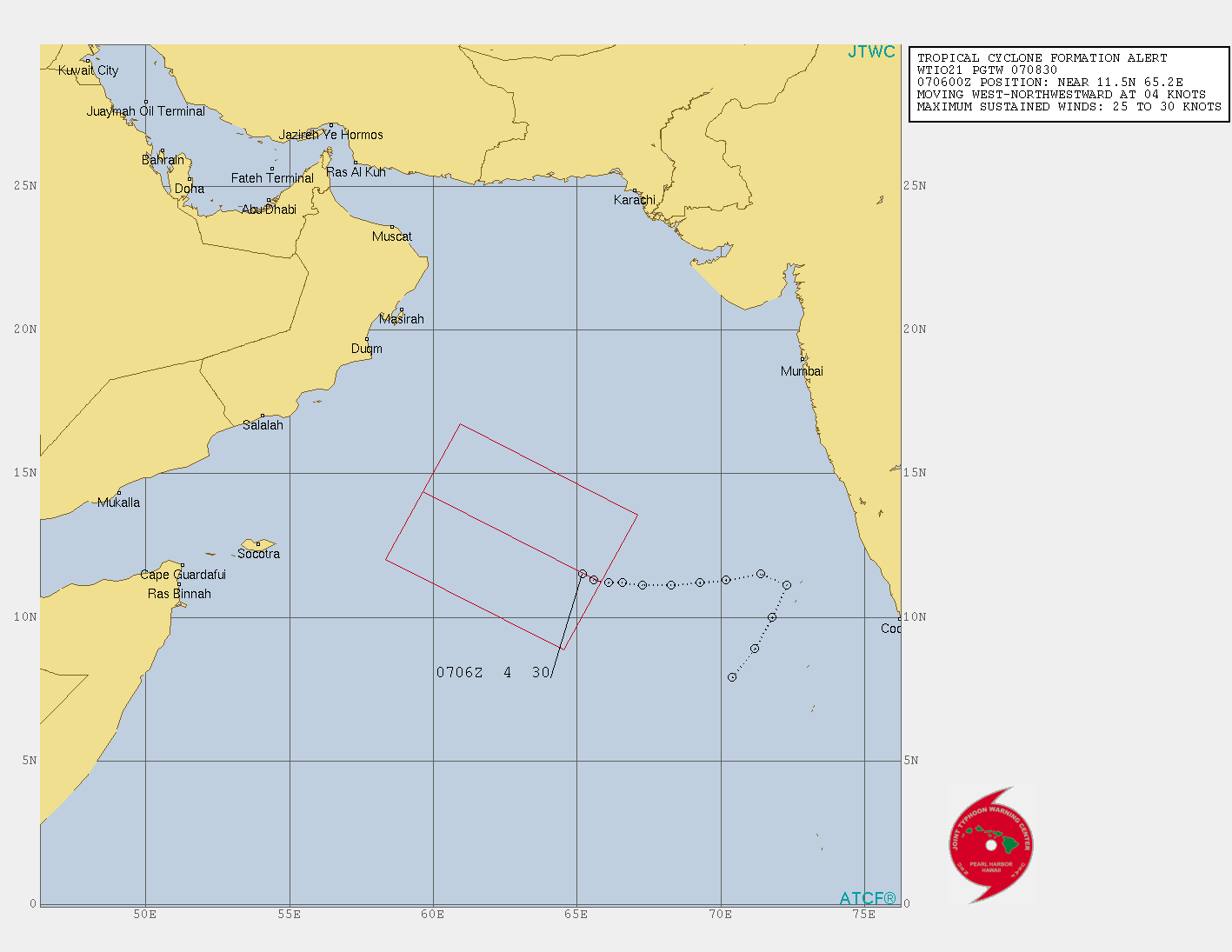
Information on Western Pacific storms can be found by clicking U.S. Navy Joint Typhoon Warning Center This (click here to read) is an unofficial private source but one that is easy to read but not being updated right now but the links to other resources work.

.


