Written by Sig Silber
Updated 5 PM EDT September 18, 2018 From WPC as of 11 AM, September 18, 2018
…FLORENCE BECOMING AN INCREASINGLY ELONGATED LOW PRESSURE AREA AS IT CONTINUES TO PRODUCE HEAVY RAIN OVER PARTS OF THE MID-ATLANTIC AND INTO SOUTHERN NEW ENGLAND TODAY…
This may be our last update since WPC will not be issuing updates and there does not appear to be much other tropical activity around the world. But Florence is still having impacts so it is possible that we will do another update Wednesday morning.
Additional information is available in the Weekly Weather and Climate Report we published late Monday night that can be accessed here. The graphics in that report in general update automatically.

Please share this article – Go to very top of page, right hand side for social media buttons.


Let us focus on Florence. This was the final WPC Advisory.
BULLETIN
Post-Tropical Cyclone Florence Advisory Number 77 NWS Weather Prediction Center College Park MD AL062018 1100 AM EDT Tue Sep 18 2018
…FLORENCE BECOMING AN INCREASINGLY ELONGATED LOW PRESSURE AREA AS IT CONTINUES TO PRODUCE HEAVY RAIN OVER PARTS OF THE MID-ATLANTIC AND INTO SOUTHERN NEW ENGLAND TODAY…
SUMMARY OF 1100 AM EDT…1500 UTC…INFORMATION
———————————————–
LOCATION…42.6N 71.9W
ABOUT 45 MI…70 KM WNW OF BOSTON MASSACHUSETTS
MAXIMUM SUSTAINED WINDS…25 MPH…35 KM/H
PRESENT MOVEMENT…ENE OR 70 DEGREES AT 25 MPH…41 KM/H
MINIMUM CENTRAL PRESSURE…1006 MB…29.71 INCHES
WATCHES AND WARNINGS
——————–
SUMMARY OF WATCHES AND WARNINGS IN EFFECT:
There are no coastal watches or warnings in effect.
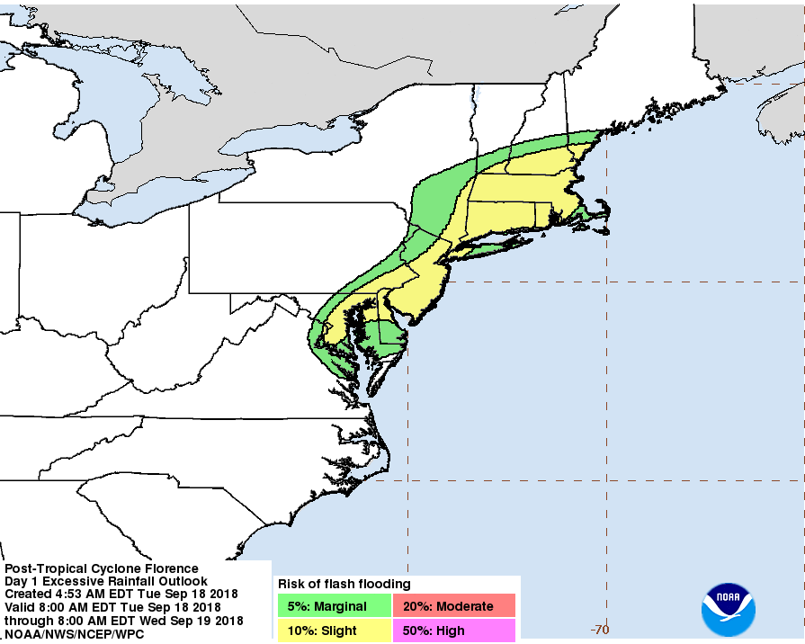
Flash flood watches are in effect for portions of the Mid-Atlantic States and southern New England.
DISCUSSION AND OUTLOOK
———————-
At 1100 AM EDT (1500 UTC), the center of Post-Tropical Cyclone Florence was located near latitude 42.6 North, longitude 71.9 West. The post-tropical cyclone is moving toward the east-northeast near 30 mph (41 km/h) and this motion is expected to increase as the low moves east into the western Atlantic later today. Maximum sustained winds are near 25 mph (35 km/h) with higher gusts. The low will transition into a trough off the East Coast tomorrow.
The estimated minimum central pressure is 1006 mb (29.71 inches).
HAZARDS AFFECTING LAND
———————-
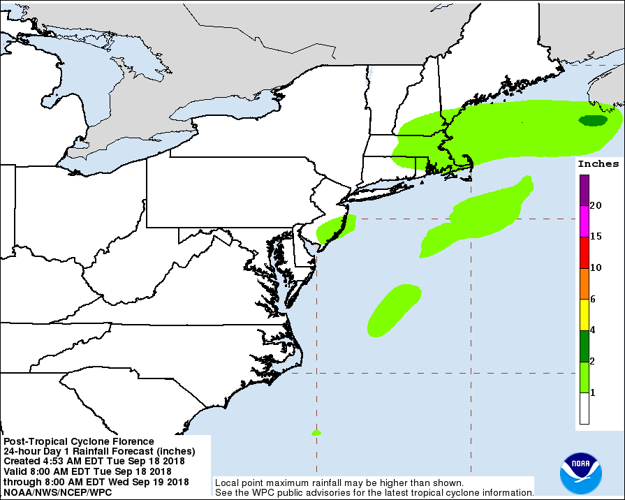
RAINFALL: Florence is expected to produce heavy to excessive rainfall from the northern Mid-Atlantic states west into southern New York and southern New England. Some of these areas are expected to receive an additional 2 to 4 inches of rain.
For more information on rainfall totals please see the Storm Summary available at www.wpc.ncep.noaa.gov/discussions/nfdscc4.html
NEXT ADVISORY
————-
This is the last public advisory issued by the Weather Prediction Center on this system.
Additional information on this system can be found in High Seas Forecasts issued by the National Weather Service, under AWIPS header NFDHSFAT1, WMO header FZNT01 KWBC, and available on the Web at http://ocean.weather.gov/shtml/NFDHSFAT1.shtml.
FORECAST POSITIONS AND MAX WINDS
INIT 18/1500Z 42.6N 71.9W 20 KT 25 MPH…POST-TROPICAL
12H 19/0000Z 43.5N 67.7W 25 KT 30 MPH…POST-TROP/EXTRATROP
24H 19/1200Z…DISSIPATED
This is a mesoscale update by WPC.


Mesoscale Precipitation Discussion 0863 NWS Weather Prediction Center College Park MD 1248 PM EDT Tue Sep 18 2018
Areas affected…Central/Eastern VA…Southern/Eastern MD…Far Southeast PA…DE..NJ…Southeast NY/Long Island…CT…RI and Southeast MA Concerning…Heavy rainfall…Flash flooding likely
Valid 181645Z – 182245Z
Summary…Heavy showers and thunderstorms with extremely heavy rainfall rates will tend to become better organized and expand in coverage going through the afternoon hours. Some flash flooding is likely.
Discussion…The latest GOES-16 1-minute visible satellite imagery shows a highly elongated surface trough extending southeast/northeast from central VA up across northern NJ and through southern New England as the Post-Tropical low center of Florence quickly traverses eastern MA. Diurnal heating via solar insolation is destabilizing the boundary layer and this is evident with an agitated CU/TCU field and cloud streets setting up within the low level southwest flow ahead of the trough. In fact, the latest RAP analysis already depicts a well-defined instability axis along and just ahead of the surface trough with MLCAPE values locally exceeding 1500 j/kg.
PWATS across the Mid-Atlantic region and southern New England and generally running between 1.9 and 2.2 inches based on the latest GPS-derived data, and again consistent with the tropical airmass brought up to the north over the last couple of days with Florence. Given the depth of tropical moisture, and with stronger instability profiles setting up this afternoon, expect a more expansive and organized axis of showers and thunderstorms with extremely heavy rainfall rates that may approach 3 inches/hr.
The latest 12Z hires model consensus, including the recent HRRR guidance supports a southeast advance of the surface trough down across the I-95 corridor and farther east across the adjacent coastal plain this afternoon. Very heavy rainfall totals of as much as 3 to 4 inches with locally heavier amounts will be possible. This will likely cause some flash flooding and especially for any urbanized areas and also any areas that have seen heavy rainfall over the last day or so.
Here is the one day forecast for heavy precipitation
Here is the risk of flash flooding
And then we can look at a larger area. Here is the 3 – Day forecast.

And the 7 Day

Florence has been turned over to Weather Prediction Center. Most Tropical Events are reported by the National Hurricane Center and additional information on those storms is available here.
Satellite Image of Florence at landfall. It covered a large area.

Tropical Storm Helene
No Statement today from Eireann. Florence has passed or bypassed Ireland.
There are possibly more storms to come. The Gulf of Mexico looks to be the location for the next new storm. But there are other possibilities also.


Tropical Weather Outlook
NWS National Hurricane Center Miami FL Issued by the NWS Weather Prediction Center College Park MD 1100 AM PDT Tue Sep 18 2018
For the eastern North Pacific…east of 140 degrees west longitude:
1. A broad and elongated area of low pressure extending from near the southern tip of the Baja California peninsula southwestward for a few hundred miles continues to produce widespread but disorganized showers and thunderstorms. Although environmental conditions appear conducive for greater organization, the large size of the system and interaction with land should inhibit the development potential of this disturbance. However, this system could still become a tropical depression during the next day or two while it moves near Baja California Sur and the Gulf of California. Regardless of development, this disturbance will likely produce very heavy rainfall over Baja California Sur and other parts of northwestern mainland Mexico over the next several days. The risk of mudlslides and flash flooding may increase as the system tracks northward into northwestern Mexico through Thursday. Interests in Baja California Sur and northwestern Mexico should monitor the progress of this disturbance.
* Formation chance through 48 hours…medium…40 percent.
* Formation chance through 5 days…medium…40 percent.
2. Another area of weak low pressure within an elongated trough is located about 800 miles southwest of the southern tip of the Baja California peninsula. Environmental conditions are expected to be conducive for gradual development of this system over the next several days while it moves slowly west-northwestward or northwestward.
* Formation chance through 48 hours…low…20 percent.
* Formation chance through 5 days…medium…40 percent.
Central Pacific Additional Information can be obtained here.

And the U.S. is not the only place dealing with cyclones.
This graphic should update and shows the situation in the Western Pacific. Addiional information can be found here.

Below is an analysis of projected tropical hazards and benefits over an approximately two-week period.


