Written by Sig Silber
At the end of every month, NOAA updates their Early Outlook for the following month – in this case March, 2018. There have been significant changes. Not surprisingly, confidence is higher in the first half of March than the second half. All of this and more is discussed in this special update.

Please share this article – Go to very top of page, right hand side for social media buttons.
Below is a graphic which highlights the forecasted surface Highs and the Lows re air pressure on Day 7.

I see the High Pressure of 1032 hPa for Greenland. It is not that impressive but apparently it is to NOAA. the High is expected to move west and eventually be near Hudson Bay. It is not necessarily the key to the March forecast but it is an interesting part of the revised forecast. It reminds us weather in CONUS is influenced by weather fairly far away.
NOAA Update of their Outlook for March, 2018
NOAA has, as usual, issued an update for the month following the last day of the prior month. This update was issued on Wednesday February 28. In this Update Report, we present the Updated Outlook and compare it to the Early Outlook for March issued on February 15, 2018 about two weeks ago. Please note: all smaller graphics can be enlarged by clicking on them or right clicking and selecting the “view image) option.
First I present a summary showing the prior and the new. Larger graphics follow but these smaller graphics can be enlarged..
| Temperature | Precipitation | |
| Prior Issued on February 15, 2018 |  |  |
| Updated on February 28, 2018 |  |  |
And now the larger graphics and my comments
Prior Temperature Forecast Issued on February 15, 2018
New Temperature Forecast Issued on February 28, 2018

Turning to Precipitation
Prior Precipitation Forecasts issued on February 15, 2018
New Precipitation Forecast Issued on February 28, 2018
Here is the NOAA Discussion released on February 28 with the March Update.
30-DAY OUTLOOK DISCUSSION FOR MARCH 2018
THE UPDATED, 0-LEAD MARCH 2018 FORECASTS EXHIBIT SOME LARGE CHANGES RELATIVE TO THE 0.5-MONTH LEAD FORECASTS DUE TO SHORT-TERM WEATHER AND SUBSEASONAL CLIMATE VARIABILITY. THE BACKGROUND ENSO STATE REMAINS IN PLAY, AND THE MJO IS CURRENTLY ACTIVE OVER THE INDIAN OCEAN, BUT FORECAST TO WEAKEN OVER THE NEXT WEEK TO TEN DAYS.
THE CURRENT 500-HPA HEIGHT PATTERN OVER NORTH AMERICA FEATURES ANOMALOUS RIDGING NEAR THE ALEUTIANS AND A VERY HIGH AMPLITUDE BLOCK OVER GREENLAND. THESE LOW-FREQUENCY FEATURES ARE FORECAST TO REMAIN INTACT OVER THE NEXT TWO WEEKS, THE LATTER SLOWLY SHIFTING WESTWARD WITH TIME TO NEAR HUDSON BAY. VARIOUS DYNAMICAL MODEL FORECASTS AND TELECONNECTIONS UPON THESE HEIGHT CENTERS FAVOR BELOW-NORMAL TEMPERATURES AND ABOVE-NORMAL PRECIPITATION OVER MUCH OF THE WEST, AND ABOVE-NORMAL TEMPERATURES OVER NEW ENGLAND AND THE NORTHERN GREAT LAKES. AS THE MONTH PROGRESSES, EXTRATROPICAL TELECONNECTIONS FROM THE MJO FAVOR A GENERAL WARMING TREND RELATIVE TO NORMAL OVER THE EASTERN AND CENTRAL CONUS.
THE MARCH OUTLOOKS ARE CONSTRUCTED BY STARTING WITH A NEW CALIBRATED CFS MONTHLY FORECAST SYSTEM THAT ACCOUNTS FOR DECREASING SKILL WITH LEAD TIME. THIS IS THEN TWEAKED BY TAKING INTO ACCOUNT THE ECMWF MONTHLY FORECAST INITIALIZED ON 26 FEB AS WELL AS THE CURRENT WPC AND CPC FORECAST SUITE THAT COVERS THE FIRST TWO WEEKS OF THE MONTH. LASTLY, STATISTICAL GUIDANCE THAT UTILIZES THE MJO, ENSO, AND LONG-TERM TRENDS ARE CONSIDERED FOR THE SECOND HALF OF THE MONTH.
THE TEMPERATURE OUTLOOK DEPICTS THE HIGHEST AMPLITUDE PROBABILITIES ACROSS PARTS OF THE NORTHERN CONUS DUE TO THE HIGH-AMPLITUDE CIRCULATION PATTERN FORECAST DURING THE FIRST HALF OF THE MONTH. UNCERTAINTY IS HIGHEST OVER THE CENTRAL AND SOUTHEASTERN CONUS WHERE PERIODS OF BELOW-NORMAL TEMPERATURES ARE FAVORED EARLY IN THE MONTH, BUT MJO, LONG-TERM TRENDS, AND DYNAMICAL FORECAST GUIDANCE FAVORS ABOVE-NORMAL TEMPERATURES LATER IN THE MONTH. ABOVE-NORMAL TEMPERATURES ARE FAVORED OVER PARTS OF SOUTHWEST AND SOUTHERN HIGH PLAINS BASED ON DYNAMICAL MODEL GUIDANCE AND STATISTICAL GUIDANCE EMPHASIZING ENSO AND LONG-TERM TRENDS. BELOW-NORMAL TEMPERATURES ARE FAVORED OVER SOUTHERN ALASKA WHERE THE WEEK-2 FORECAST STRONGLY FAVORS COLDER-THAN-NORMAL TEMPERATURES. LONG-TERM TRENDS AND REDUCED SEA ICE COVERAGE RELATIVE TO NORMAL CONTRIBUTE TO PROBABILITIES FAVORING ABOVE-NORMAL TEMPERATURES OVER NORTHWESTERN ALASKA.
THE PRECIPITATION OUTLOOK CENTERS ON FOUR REGIONS OVER THE CONUS THAT ARE EXPECTED TO SEE ENHANCED PRECIPITATION EARLY IN THE MONTH, NAMELY, MUCH OF THE WESTERN CONUS, THE UPPER AND LOWER MISSISSIPPI VALLEY, AND PARTS OF THE NORTHEAST. LOWER-FREQUENCY CLIMATE FORCING FROM ENSO, MJO, AND LONG-TERM TRENDS FAVORS BELOW-NORMAL PRECIPITATION OVER PARTS OF FLORIDA, THE SOUTHWEST, AND SOUTHERN HIGH PLAINS. THE OHIO VALLEY AND THE NORTHERN PLAINS TILT TOWARD ABOVE-NORMAL PRECIPITATION BASED ON THESE LOW-FREQUENCY CLIMATE FACTORS. THE AFOREMENTIONED BLOCK OVER NORTHEASTERN NORTH AMERICA FAVORS BELOW-NORMAL PRECIPITATION OVER FAR NORTHERN NEW ENGLAND AND THE NORTHERN GREAT LAKES. OVER ALASKA, A RELATIVELY WET PATTERN IS FORECAST EARLY IN THE MONTH FOR THE WESTERN PART OF THE STATE, WHILE FORECAST RIDGING NEAR THE ALEUTIANS FAVORS BELOW-NORMAL PRECIPITATION OVER THE SOUTHERN PART OF THE STATE.
Sometimes it is useful to see how the Monthly forecast fits with the 6 – 10 Day , 8 – 14 Day and Week 3 and 4 forecasts. To be complete we should look at Day 1 – 5 also. I do not have maps for the Day 1 – 5 forecast in the same format as the three maps we generally work with. What I am showing is the Day 3 Maximum Temperature and the five-day precipitation: the latter being fairly similar in format to the subsequent set of the maps I present each week.
First the short-term Five Day Maps
| Temperature | Precipitation |
 |  |
Then our regular set of forecast maps.
First Temperature
 |  |  |
| The new monthly forecast is to the right. Does it appear to be reflective of the three parts of the month for which we have forecasts? → |
| ↑ ← The full month forecast seems to fit very well with the Week 3/4 forecast which will be updated on Friday. Week one is not shown here but is shown just above this table. |
And then Precipitation
 |  |  |
| The new monthly forecast is to the right. Does it appear to be reflective of the three parts of the month for which we have forecasts? → | | ↑ ← The Week 3/4 forecast is the driest of the four maps. It is fairly similar to the 8 – 14 Day Forecast. The concatenation of these three maps does not fit well with the full month map. The Week 3-4 Map will be updated on Friday and may look very differently than it does now and off course will cover a different time period since it will be one week later. |
Sometimes it is useful to compare the forecast for the current month with the three-month forecast.
March 2018 Plus February March – May 2018 Outlook

One can mentally subtract the First-Month Outlook from the Three-month Outlook and create the Outlook for the last two months in the three-month period.
*The concept is that the probabilities of a deviation from climatology in the First Month and the combined Month Two and Three forecast that one derives must average out to the probabilities shown in the three-month maps.
Additional Discussion of the Factors Impacting the February 28 Forecast for March and which are inherently able to be forecast more precisely at the end of the month than for the Early Outlook issued on the third Thursday of the Month
A. Arctic Oscillation (AO)
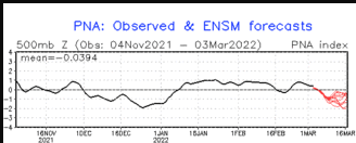
P. Pacific North American Pattern (PNA)
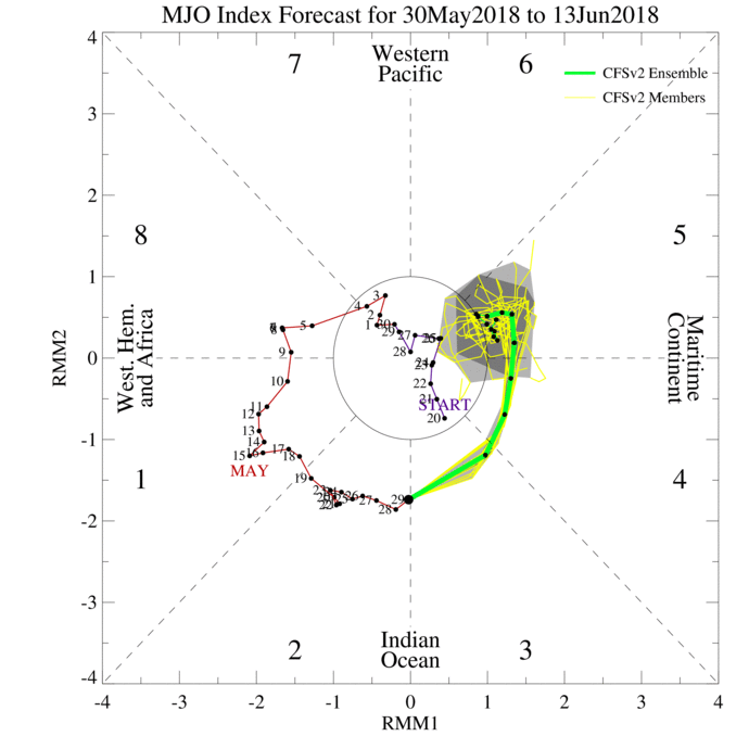
C. Madden Julian Oscillation (MJO)

The Arctic Oscillation (AO) is a climate index of the state of the atmospheric circulation over the Arctic. It consists of a positive phase, featuring below average geopotential heights , which are also referred to as negative geopotential height anomalies , and a negative phase in which the opposite is true. In the negative phase, the polar low pressure system (also known as the polar vortex) over the Arctic is weaker, which results in weaker upper level winds (the westerlies). The result of the weaker westerlies is that cold, Arctic air is able to push farther south into the U.S., while the storm track also remains farther south. The opposite is true when the AO is positive: the polar circulation is stronger which forces cold air and storms to remain farther north. The Arctic Oscillation often shares phase with the North Atlantic Oscillation (NAO) (discussed below), and its phases directly correlate with the phases of the NAO concerning implications on weather across the U.S.
B. PNA Pacific North American Pattern:
C. MJO: Madden Julian Oscillation
| NCEP-NEFS | CFSv2 |
|  |

We wonder how the new forcast for March might impact the Drought Situation.
The U.S. Drought Monitor is a comprehensive way of understand the drought situation for the U.S. If is issued every Thursday and reflects the conditions as of the prior Tuesday. The drought monitor is not just based on precipitation but the condition of the land so it generally reflects more than a month’s precipitation and temperature and wind.

Because of the current drought conditions we now publish a Drought Update on Thursdays. You can access the most recent report here. That report will be update tomorrow.
I now show the 30 Day and 90 Day Temperature and Precipitation History. As you can see, the lack of precipitation has persisted for a while and has gotten more extreme as has the warm anomaly relative to the time of the year.
| 30 Day | 30DayTemperatureandPrecipitationDepartures.png) |
| 90 Day | 90DayTemperatureandPrecipitationDepartures.png) |


