Written by Sig Silber
NOAA is dealing with a complicated combination of variables and the forecast models are not providing consistent forecasts. We have a weak La Nina that has peaked, a MJO that is stronger than usual for La Nina Conditions, and there are questions about the overall Global Circulation which recently was described as questions about the Wavenumber (4 or 5 repetitions around the Globe?). There is some consensus that we are likely to have for January a stronger Jet Stream arriving from Asia, less impact from blocking patterns and thus faster progression of patterns from west to east. But I would not bet the farm on any of this.

Please share this article – Go to very top of page, right hand side for social media buttons.
To avoid confusion we are publishing the January Update tonight and will publish our regular weekly report on Tuesday (January 2), one day later than usual. If you have not had a chance to read the Full Seasonal Update of NOAA and JAMSTEC and our comparison you can find that here. This article updates the Early Forecast for January that was released on December 21, 2016 ten days ago and updated on December 31, 2017.
NOAA Update of their Outlook for January, 2018
NOAA has, as usual, issued an update for the month following the last day of the prior month. This update was issued on Sunday December 31. In this Update Report, we present the Updated Outlook and compare it to the Early Outlook for January issued on December 21, 2017 about ten days ago. Please note: all small graphics can be enlarged by clicking on them.
First I present a summary showing the prior and the new. Large graphics follow but these smaller graphics can be clicked on to enlarge.
| Temperature | Precipitation | |
| Prior Issued on December 21, 2017 |  |  |
| Updated on December 31, 2017 |  |  |
And now the larger graphics and my comments
Prior Temperature Forecast Issued on December 21, 2017
New Temperature Forecast Issued on December 31, 2017

Prior Precipitation Forecasts issued on December 21, 2017
New Precipitation Forecast Issued on December 31, 2017
Here is the NOAA Discussion released on December 31 with the January Update.
30-DAY OUTLOOK DISCUSSION FOR JANUARY 2018
LA NINA CONDITIONS REMAIN IN PLACE OVER THE PACIFIC OCEAN, WITH A CORRESPONDING ATMOSPHERIC RESPONSE THAT IS LARGELY CONSISTENT WITH CANONICAL LA NINA IMPACTS OVER MUCH OF THE PACIFIC. DOWNSTREAM IMPACTS, OVER NORTH AMERICA, ARE BEING INFLUENCED BY EXTRATROPICAL MODES AS WELL, SO THE LA NINA RESPONSE IS NOT AS CLEAR. THE MJO HAS STRENGTHENED AND THE CONVECTIVELY ACTIVE PHASE IS NOW LOCATED OVER THE INDIAN OCEAN, PHASE 2 IN THE WHEELER-HENDON PHASE SPACE MODEL. THE MJO INTRODUCES A SIGNIFICANT SOURCE OF UNCERTAINTY IN THE OUTLOOK.
CHANGES TO THE PRIOR OUTLOOK ARE BASED ON RECENT MODEL GUIDANCE AND THE EMERGENCE OF THE MJO OVER THE INDIAN OCEAN. SHORT-TERM MODEL GUIDANCE AND OFFICIAL OUTLOOKS PREDICT COLDER THAN NORMAL CONDITIONS OVER THE EASTERN CONUS, WITH THE FIRST WEEK SIGNIFICANTLY BELOW AVERAGE FROM THE MISSISSIPPI VALLEY TO THE EAST COAST. SOME MODERATION IS PREDICTED IN THE WEEK-2 TIME PERIOD, MOSTLY OVER THE SOUTHEAST. THIS PREDICTED MODERATION WOULD BE CONSISTENT WITH LAGGED IMPACTS FROM A PHASE-2 MJO. OVER THE SOUTHERN PLAINS, THE REVISED OUTLOOK IS COLDER THAN THE MID-MONTH OUTLOOK, RELATED TO THE VERY EARLY COLD, THE WEEK-2 OUTLOOKS FAVORING BELOW NORMAL TEMPERATURES, AND SOME POTENTIAL IMPACT FROM MJO ACTIVITY WITH TROUGHING OVER THE WESTERN CONUS. ODDS FOR ABOVE NORMAL TEMPERATURES WERE INCREASED ACROSS THE GREAT BASIN AND SOUTHERN OREGON, SUPPORTED BY SHORT-TERM WARMTH AND MODEL GUIDANCE FOR THE FULL MONTH. LATER IN THE MONTH, UNCERTAINTY INCREASES AS LAGGED IMPACTS FROM THE MJO WOULD FAVOR COOLER TEMPERATURE AND TROUGHING ALONG THE WEST COAST, SO PROBABILITIES ARE STILL MODEST. OVER FLORIDA, SOME MODERATION IN TEMPERATURES WITH A SLIGHT TILT TOWARD ABOVE NORMAL TEMPERATURES IS INDICATED IN THE LAST FEW DAYS OF CFS RUNS, AND WOULD BE CONSISTENT WITH LA NINA CONDITIONS.
THE UPDATED PRECIPITATION OUTLOOK IS MORE UNCERTAIN THAN THE ACCOMPANYING TEMPERATURE OUTLOOK. RUN-TO-RUN CONSISTENCY IN THE CFS IS QUITE LOW. THE CFS OUTPUT FOR THE MONTHLY TOTALS AND WEEK 3-4, AS WELL AS SOME SHORTER-TERM OFFICIAL OUTLOOKS, SHOW INCREASED ODDS FOR PRECIPITATION OVER THE CENTRAL PLAINS TO THE OHIO VALLEY. NORTH OF THAT, THERE ARE CONSISTENT SIGNALS FOR DRYNESS OVER THE UPPER MIDWEST IN MONTHLY MODEL RUNS. A BRIEF WET PERIOD IN THE MIDDLE OF THE MONTH, AS DEPICTED IN WEEK-2 OUTLOOKS IS POSSIBLE FOR THE MIDWEST. DRYER THAN NORMAL CONDITIONS ARE STILL FAVORED OVER THE SOUTHERN PLAINS, WITH AN AREA OF BELOW NORMAL PRECIPITATION NOW ADDED TO FLORIDA, BOTH CONSISTENT WITH LA NINA AND MONTHLY GUIDANCE FROM THE CFS. LAGGED COMPOSITES ON MJO ACTIVITY INCLUDE TROUGHING FROM THE PACIFIC NORTHWEST TO THE FOUR CORNERS REGION, FOR THE EARLY PORTION OF THE MONTH, WITH MORE TROUGHING OVER THE SOUTHWEST THROUGH MID MONTH, WHICH RESULTED IN THE REDUCTION IN COVERAGE FOR BELOW NORMAL PRECIPITATION OVER ARIZONA AND SOUTHERN CALIFORNIA. FOR NORTHERN CALIFORNIA, SOME TROUGHING AND PRECIPITATION ARE PREDICTED EARLY IN THE MONTH, THOUGH SOME OF THOSE PREDICTED WEEKLY QPF TOTALS ARE CLOSE TO OR JUST BELOW NORMAL FOR WEEKLY NORMALS. LATER LAGS ON MJO COMPOSITES WOULD FAVOR SOME RIDGING OVER THE PACIFIC NORTHWEST LATER IN THE MONTH, WHICH IMPLIES BELOW NORMAL STORM ACTIVITY AND BELOW NORMAL PRECIPITATION FOR CALIFORNIA, WHICH WOULD BE CONSISTENT WITH LA NINA CONDITIONS AS WELL.
This discussion on Week 3 and 4 was issued on December 29, 2017 and might also be of interest and is very detailed.
Week 3-4 Forecast Discussion Valid Sat Jan 13 2018-Fri Jan 26 2018
The current Week 3-4 outlook continues to suggest a substantial evolution of the large-scale pattern over North America. At present, bitterly cold Arctic air is spread over the eastern half of the CONUS, while persistent anomalous warmth has remained over Alaska. The current circulation appears somewhat tied to the active phase of the Madden-Julian Oscillation, which presently extends across the Western Hemisphere. Lagged composites of the MJO in Phase 7 (over the West Pacific) supports anomalous cold air descending from the Northern Plains through the eastern U.S., along with the anomalous ridging for Alaska that is currently being observed. The MJO presence over the Western Hemisphere is less favorable for extratropical teleconnections, but if the convective envelope reaches the Indian Ocean, as is forecast in the next few days, extratropical responses again become favored via interactions with the East Asian waveguide. As such, the Week 3-4 outlook follows a blend of dynamical model guidance along with empirical guidance relating lagged responses from an MJO signal over the Indian Ocean. These would suggest extension of the Pacific Jet (troughing over Alaska, ridging north of Hawaii) and ridging building across the east; each a substantial departure from recent observations. The response to an MJO event in Phase-2 also favors anomalous negatively-tilted troughing from the Pacific Northwest through Southern Rockies, which the dynamical model guidance supports to varied extents. The current outlook is based predominantly on empirical guidance related to the MJO and La Nina coupled with dynamical model guidance that is consistent among prediction systems and with the aforementioned statistical guidance.
Dynamical model forecasts spanning the Week 3-4 period are somewhat mixed, with general consensus between the CFS, JMA, and most of the Sub-X models supporting: anomalous troughing over Alaska, ridging over California and the eastern Seaboard (associated with the positive phase of the North-Atlantic Oscillation), and either a weakness in anomalous ridging or slight anomalous troughing focused on the Northern Rockies through Southern Plains. The ECMWF is an outlier this week, with blocking over Alaska that projects strongly onto the positive phase of the North Pacific Oscillation-West Pacific (NPO-WP) pattern. This is a reversal from the ECMWF outlook last week, which previously forecast the negative NPO-WP structure now favored by the CFS and JMA. Given the ECMWF’s inconsistency over the last week and its atypical evolution of the Northern Hemisphere circulation relative to the expected MJO response, it was discounted in this outlook compared to the other dynamical models.
The highest forecast probabilities relating to temperature in the current outlook are for above-normal values over the eastern CONUS. A warming trend is apparent here in the evolution between the 6-10 and 8-14 day periods and is anticipated to continue throughout the Week 3-4 timeframe given the typical MJO response and consistent ridging placed here by the dynamical model guidance. The anomalous warmth is also forecast with lesser probabilities to extend across the Southern Plains and into the Southwest, consistent with Week-2 and ridging forecast near the Pacific coastline. A small area of below-normal temperatures is forecast over the Northern Rockies during Week 3-4 in line with the lagged MJO response from the Multiple-Linear Regression tool, MJO composites, and weakness in the forecast height fields among the model guidance. The background La Nina state would also suggest enhanced odds for anomalously cold temperatures across the Northern Rockies, giving further support for inclusion of these potential below-normal temperatures.
With extension of the jet across the Pacific favored in this outlook, the majority of model guidance places above-normal precipitation into the Alaska Panhandle and portions of the Pacific Northwest. There is some uncertainty among the exact orientation of the jet, which limits confidence in these forecast probabilities. Much of California and the Southwest is favored to experience below-normal precipitation given the favored jet placement being north of the region, and the background La Nina state favoring anomalous dryness. Model guidance is consistent in forecasting above-normal precipitation from the Midwest through the Mid-Atlantic in association with shortwave features digging through the weakness in the height field forecast across the West. Below-normal rainfall is also forecast for Florida and parts of the Southeast, given the robust La Nina footprint for the region and the anticipated storm track being north of this area. Lastly, a relatively small portion of southern mainland Alaska is favored for below-normal precipitation with the jet anticipated to be south of the region.
The Hawaiian outlook for Week 3-4 remains highly uncertain as with the prior week. Sea-surface temperature anomalies are now negative across much of the immediate vicinity, though dynamical forecasts for Week 3-4 favor a slight tilt toward above-normal 2-meter temperatures with anomalous ridging forecast near the islands. Given the latest bias-corrected Week-2 guidance, and the lower-frequency nature of climate variability in the tropics, a slight tilt toward below-normal temperatures is indicated across the entire archipelago. Dynamical model guidance suggests enhanced precipitation probabilities further east in the island chain, in line with the greater positive SST anomalies for this region. As such, below-normal rains are forecast in the West with slightly enhanced rainfall probabilities for Hilo.
Sometimes it is useful to see how the Monthly forecast fits with the 6 – 10 Day , 6 – 14 Day and Week 3 and 4 forecasts. To be complete we should look at Day 1 – 5 also. I do not have maps for the Day 1 – 5 forecast in the same format as the three maps we generally work with. What I am showing is the Day 3 Maximum Temperature and the five-day precipitation: the latter being fairly similar in format to the subsequent set of the maps I present each week.
First the short-term Five Day Maps
| Temperature | Precipitation |
 |  |
Then our regular set of forecast maps.
First Temperature
 |  |  |
| The new monthly forecast is to the right. Does it appear to be reflective of the three parts of the month for which we have forecasts? → |
| ↑ ← It does not seem to fit together. If the Week 3/4 forecast is correct the full month forecast can not be. Of course the actual may differ from all of the above. |
And then Precipitation
 |  |  |
| The new monthly forecast is to the right. Does it appear to be reflective of the three parts of the month for which we have forecasts? → | | ↑ ← I have a problem with this one. Alaska looks ok but if you believe that the three short-tem outlooks above are correct, then the full month outlook to the left is not correct. Of course none of the forecasts may be correct. |
Sometimes it is useful to compare the present month outlook to the three-month outlook to see what we might learn about the next two months which in this case are February and March 2018.
January 2018 Plus January – March 2018 Outlook

One can mentally subtract the First-Month Outlook from the Three-month Outlook and create the Outlook for the last two months in the three-month period.
*The concept is that the probabilities of a deviation from climatology in the First Month and the combined Month Two and Three forecast that one derives must average out to the probabilities shown in the three-month maps.
 The 30 Day SOI index is more like an El Nino value than a La Nina value. This may have been caused by the MJO. But we will continue to monitor that in the Weekly Report.
For those who missed the Weekly Report which provides additional detail on how this will unfold with respect to the Days 6 – 10, 8 – 14 and weeks 3 and 4, you can access that report here. There will be a new Weekly Report on Tuesday January 2
Now without much explanation we present some of the factors that NOAA considered in making this forecast. Most are mentioned in their discussion.
NPO-WP
It is all connected. But not easy to explain
What is the NPO-WP? Here are some resources….this is good and this is more recent and looks at it on a Worldwide basis. For now we will go with the American Meteorological Society definition.
The North Pacific Oscillation (NPO) is a north–south seesaw in winter sea level pressure over the North Pacific on monthly (and shorter) time scales. It was defined in 1924 by Sir Gilbert Walker as “the opposition between Alaska, representing the area of low pressure, and Honolulu near the margin of the high pressure area, the coefficients in winter and spring being −0.70 and −0.52.”
The tropospheric circulation pattern linked with NPO variability is the west Pacific (WP) teleconnection. NPO/WP variability is linked to meridional displacements of the Asian-Pacific jet and Pacific storm tracks. Intercomparison of sea level pressure, geopotential height, and zonal wind anomaly structure reveals NPO to be a Pacific basin analog of the North Atlantic Oscillation.
NPO/WP variability is influential on North American winter hydroclimate: the positive NPO phase (deeper Aleutian low) results in warming of the North American continent, except for the western United States, and in less (more) precipitation over the Pacific Northwest (southern Great Plains). NPO/WP also impacts marginal sea ice zones, with the western Bering Sea and Sea of Okhotsk ice zones significantly extended during the positive NPO phase.
We have discussed this before in an article that might have been entitled “Beringia” which was mostly about strength and positioning of the Aleutian Low with respect to ENSO. The issue right now is more short-term oriented and we will discuss this more in a future article because of what was said in the Friday December 22 Week 3-4 forecast.
This pattern projects strongly onto the negative phase of the NPO-WP pattern. The forecast pattern becomes uncertain heading into the Week 3-4 period, with the ECMWF supporting a large pattern change with anomalous troughing developing near Alaska and enhanced westerlies into western North America (and the associated reversal of the NPO-WP to the positive phase).
But there was a complete reversal in the Friday December 29 Week 3 – 4 Report
The ECMWF is an outlier this week, with blocking over Alaska that projects strongly onto the positive phase of the North Pacific Oscillation-West Pacific (NPO-WP) pattern. This is a reversal from the ECMWF outlook last week, which previously forecast the negative NPO-WP structure now favored by the CFS and JMA. Given the ECMWF’s inconsistency over the last week and its atypical evolution of the Northern Hemisphere circulation relative to the expected MJO response, it was discounted in this outlook compared to the other dynamical models.
Some believe that this pattern has more short-term impact on CONUS weather than ENSO. So we will be tracking this.
The models are disagreeing and changing their minds. It looks like this has to do with the Wavenumber 5 possibility that we were dealing with a couple of weeks ago. Things are changing day be day
AO: Arctic Oscillation: Notice the Index has been generally negative and is forecast to be negative for about week. NO Neg can lead to Arctic Cold Intrusions.

The Arctic Oscillation (AO) is a climate index of the state of the atmospheric circulation over the Arctic. It consists of a positive phase, featuring below average geopotential heights , which are also referred to as negative geopotential height anomalies , and a negative phase in which the opposite is true. In the negative phase, the polar low pressure system (also known as the polar vortex) over the Arctic is weaker, which results in weaker upper level winds (the westerlies). The result of the weaker westerlies is that cold, Arctic air is able to push farther south into the U.S., while the storm track also remains farther south. The opposite is true when the AO is positive: the polar circulation is stronger which forces cold air and storms to remain farther north. The Arctic Oscillation often shares phase with the North Atlantic Oscillation (NAO) (discussed below), and its phases directly correlate with the phases of the NAO concerning implications on weather across the U.S.
Source North Carolina Climate Office
PNA Pacific North American Pattern: Notice the PNA has been running a bit positive. And again it is forecast to remain positive for the first week of January. PNA positive

The Pacific/ North American teleconnection pattern (PNA) is one of the most prominent modes of low-frequency variability in the Northern Hemisphere extratropics. The positive phase of the PNA pattern features above-average heights in the vicinity of Hawaii and over the intermountain region of North America, and below-average heights located south of the Aleutian Islands and over the southeastern United States. The PNA pattern is associated with strong fluctuations in the strength and location of the East Asian jet stream. The positive phase is associated with an enhanced East Asian jet stream and with an eastward shift in the jet exit region toward the western United States. The negative phase is associated with a westward retraction of that jet stream toward eastern Asia, blocking activity over the high latitudes of the North pacific, and a strong split-flow configuration over the central North Pacific.
The positive phase of the PNA pattern is associated with above-average temperatures over western Canada and the extreme western United States, and below-average temperatures across the south-central and southeastern U.S. The PNA tends to have little impact on surface temperature variability over North America during summer. The associated precipitation anomalies include above-average totals in the Gulf of Alaska extending into the Pacific Northwestern United States, and below-average totals over the upper Midwestern United States.
|
| Source North Carolina State Climate Office |
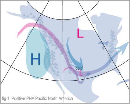
Although the PNA pattern is a natural internal mode of climate variability, it is also strongly influenced by the El Nino/Southern Oscillation (ENSO) phenomenon. The positive phase of the PNA pattern tends to be associated with Pacific warm episodes (El Nino), and the negative phase tends to be associated with Pacific cold episodes (La Nina).
One set of current forecasts


