Written by Sig Silber
3:40PM EDT 17Oct2017 From British Met now called Met Office: “The remains of Ex-Ophelia are moving away from the UK towards Scandinavia, weakening as they do so. Winds in northeast UK are easing” The best source of information remains British Met Click Here. Another soure is YR Click Here.

Please share this article – Go to very top of page, right hand side for social media buttons.

Not much left. Further north now.

Source: yr.no is a Norwegian website for weather forecasting and other meteorological information (which is also in English). The site is a joint responsibility of the Norwegian Broadcasting Corporation and the Norwegian Meteorological Institute.
Latest news can be found here, here and here. Here is a particularly good one. Some include many photos and animations.
/cdn.vox-cdn.com/uploads/chorus_image/image/57165769/861933120.0.jpg)

9AM EDT October 16, 2017

Current Estimate of Track [The below has not been updated and is no longer being updated by the U.S. NHC]

Wind Speed

Experimental Wind Arrival

Final NHC Discussion
Post-Tropical Cyclone Ophelia Discussion Number 28 NWS National Hurricane Center Miami FL 1100 PM AST Sun Oct 15 2017
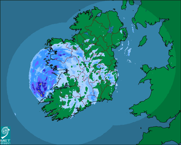
Within just the past six hours, the last bit of deep convection near Ophelia’s center has been sheared off well to the north, and the cyclone has acquired a definitive extratropical structure. Ophelia has completed its transition to an occluded low, with an attached warm front extending northeastward across Ireland and a cold front draped southeastward toward Spain and Portugal. The powerful cyclone continues to produce hurricane-force winds, with recent ASCAT data showing wind vectors as high as 70 kt to the east of the center. Based on these data, the initial intensity remains 75 kt to account for undersampling. The occluded low is forecast to gradually fill and weaken during the next couple of days, and it is likely to dissipate near the western coast of Norway by 48 hours. Despite the expected weakening, the post-tropical cyclone is still likely to bring hurricane-force winds, especially in gusts, to portions of western Ireland on Monday.
Ophelia has accelerated and retrograded slightly during the past 6-12 hours during the occlusion process, and the long-term motion estimate is northward, or 010/38 kt. Now that occlusion is complete, the post-tropical cyclone should resume a north- northeastward motion, with some decrease in forward speed, within the next 12 hours. That heading should continue for the ensuing day or two, bringing the center of the cyclone near the western coast of Ireland on Monday and then near northern Scotland Monday night. The dynamical track models remain in good agreement on this scenario, and the updated NHC forecast is not too different from the previous one.
This is the last advisory issued by the National Hurricane Center now that Ophelia has become post-tropical. Local forecasts, warnings, and other communications regarding the post-tropical cyclone that are pertinent to Ireland and the United Kingdom will continue to be available from Met Eireann and the UK Met Office.
KEY MESSAGES:
1. Ophelia will remain a powerful extratropical cyclone with hurricane-force winds while it moves near Ireland and the United Kingdom Monday and Monday night. Strong winds and heavy rain are likely in portions of these areas, along with dangerous marine conditions. For more details on the magnitude, timing, and location of impacts from post-tropical Ophelia, residents in Ireland should refer to products issued by Met Eireann, and residents in the United Kingdom should refer to products issued by the Met Office.
2. Individuals are urged to not focus on the exact track of Ophelia since strong winds and heavy rainfall will extend well outside of the NHC forecast cone.
FORECAST POSITIONS AND MAX WINDS
INIT 16/0300Z 49.2N 13.3W 75 KT 85 MPH…POST-TROP/EXTRATROP
12H 16/1200Z 53.2N 10.1W 65 KT 75 MPH…POST-TROP/EXTRATROP
24H 17/0000Z 57.4N 5.9W 50 KT 60 MPH…POST-TROP/EXTRATROP
36H 17/1200Z 61.9N 0.1W 40 KT 45 MPH…POST-TROP/EXTRATROP
48H 18/0000Z…DISSIPATED


