Written by Sig Silber
This Article has been updated. You can access the updated article at: Bahamas Next But Reduced- Puerto Rico Impacts Continue – 22Sep2017
12:15 PM EDT Sept 22, 2017: LATEST FROM NHC: “…MARIA STILL PRODUCING 125-MPH WINDS AS IT PASSES NORTHEAST OF THE TURKS AND CAICOS ISLANDS…” “GOVERNMENT OF THE DOMINICAN REPUBLIC HAS DISCONTINUED ALL WARNINGS FOR THE DOMINICAN REPUBLIC.”

Please share this article – Go to very top of page, right hand side for social media buttons.
Damage Reports from the recent impacts of Hurricane Maria start to trickle in. Here is one. And here is an impact assessment and analysis and an update from the same source. This report is focused on Puerto Rico. Our coverage on impacts will expand as more information becomes available.
This is an active period in the tropics so we are starting with the overview of the situation in both the Pacific and the Atlantic even though right now only the Pacific presents major threats. Those potentially impacted by any of these storms should consult their local sources of information. The Public Advisories and other information that is available from the NOAA National Hurricane Center can be found here. Information from the Weather Prediction Center can be found here.
First the Atlantic

More Detail

And now the Pacific.

We start our Report with Hurricane Maria. The”M” Designation means a very powerful storm: Category 3 or higher.


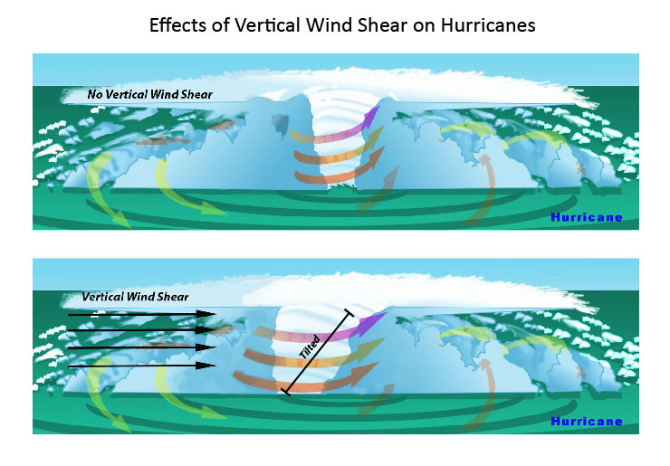
Learn more about wind shear here.
And the Discussion
Hurricane Maria Discussion Number 24 NWS National Hurricane Center Miami FL 1100 PM EDT Thu Sep 21 2017
Satellite images show that the eye has become more distinct and is surrounded by a ring of deep convection. An Air Force Hurricane Hunter plane has penetrated the eye a couple of times this evening and the crew reported that the eye had a diameter of 35 nmi and that it has become better defined. Flight-level winds increased a little bit during the last penetration and supported an intensity of 110 or 115 kt. At this time, I prefer the keep the winds at 110 kt since the SFMR measurements were a little lower. The central pressure is estimated at 955 mb.
The atmosphere diagnosed by the models, as well as a warm ocean along the forecast track, should favor an increase in intensity. However, most of the models, suggest that Maria will change little and will remain a category 3 hurricane for the next day or two. The NHC forecast follows the intensity consensus ICON and shows no significant change through that time. Gradual weakening should begin later in the forecast period as Maria reaches higher latitudes and cooler waters.
Satellite and reconnaissance fixes indicate that Maria is moving toward the northwest or 320 degrees at 7 kt. The track of the hurricane has been and will be controlled by the flow around a narrow subtropical ridge to the northeast of the hurricane. Maria is reaching the western edge of that high, and this should cause the hurricane to turn north-northwestward and then northward with no significant change in forward speed for the next 3 days. After that time, Maria should encounter the mid-latitude southwesterly flow and recurve. The reliable guidance is remarkably clustered during the next 4 days. This significantly increases the confidence in the track forecast which is in between the multi-model consensus TVCX and the HFIP corrected consensus.
KEY MESSAGES:
1. Flash flood warnings continue in portions of Puerto Rico due to persistent heavy rainfall from Maria’s trailing rainbands. Everyone in Puerto Rico should continue to follow advice from local officials to avoid these life-threatening flooding conditions.
2. Swells from Maria are expected to begin reaching the coast of the southeastern United States on Friday. These swells are likely to cause dangerous surf and life-threatening rip currents along the coast for the next several days, even with Maria forecast to remain well offshore over the western Atlantic Ocean.
FORECAST POSITIONS AND MAX WINDS
INIT 22/0300Z 21.0N 70.2W 110 KT 125 MPH
12H 22/1200Z 22.0N 70.8W 110 KT 125 MPH
24H 23/0000Z 23.5N 71.5W 105 KT 120 MPH
36H 23/1200Z 25.1N 72.0W 100 KT 115 MPH
48H 24/0000Z 26.7N 72.3W 95 KT 110 MPH
72H 25/0000Z 29.3N 72.1W 90 KT 105 MPH
96H 26/0000Z 31.2N 71.0W 85 KT 100 MPH
120H 27/0000Z 33.0N 70.0W 75 KT 85 MPH
Here is the current Track Map for Jose.


Jose Discussion
Post-Tropical Cyclone Jose Discussion Number 67 NWS National Hurricane Center Miami FL 1100 PM AST Thu Sep 21 2017
The center of Jose has lacked deep convection for at least the past 12 hours. The cyclone now has the structure of an extratropical cyclone, with rain persisting in a shield that is displaced well to the west and northwest of the center. Based on this, Jose has been declared post-tropical. Surface observations from extreme southeast New England during the past 3 hours indicate that tropical storm conditions are persisting along the coast, and the tropical storm warnings in those locations remain in place. The National Hurricane Center will continue to issue advisories on Jose until the threat of tropical storm conditions along the coast has subsided.
The initial intensity has been held at 45 kt, based on a recent ASCAT pass that showed several 40-45 kt wind vectors in the NW quadrant. No change has been made to the intensity forecast, and Jose is still expected to gradually spin down over the cold waters of the North Atlantic for the next 3 days. Most of the global models still show the remnant low dissipating within 96 h.
Jose remains stuck in weak steering flow and has continued to drift slowly westward. Very little change has been made to the track forecast, and all of the global models show that the cyclone will continue to meander off the New England coast until it eventually dissipates around day 4. The NHC forecast remains close to the various track consensus aids.
Based on data from the aforementioned ASCAT pass, the wind radii were extended in the NW and NE quadrants. However this wind appears to be primarily occurring offshore, to the east of Cape Cod.
KEY MESSAGES:
1. Tropical-storm-force winds, especially in gusts, are occurring within the tropical storm warning area. These conditions are expected to continue through tonight.
2. Minor coastal flooding is possible along portions of the coast of southern New England during the next few days. Please see products issued by local National Weather Service forecast offices.
3. Swells generated by Jose are affecting Bermuda and much of the U.S. east coast, and will likely cause dangerous surf and rip current conditions for the next couple of days in these areas.
FORECAST POSITIONS AND MAX WINDS
INIT 22/0300Z 39.5N 68.4W 45 KT 50 MPH…POST-TROPICAL
12H 22/1200Z 39.6N 68.7W 40 KT 45 MPH…POST-TROPICAL
24H 23/0000Z 39.5N 69.0W 40 KT 45 MPH…POST-TROPICAL
36H 23/1200Z 39.3N 68.5W 35 KT 40 MPH…POST-TROPICAL
48H 24/0000Z 39.1N 67.3W 30 KT 35 MPH…POST-TROP/REMNT LOW
72H 25/0000Z 38.8N 66.5W 25 KT 30 MPH…POST-TROP/REMNT LOW
96H 26/0000Z…DISSIPATED
General Weather Situation
We believe that it is easier to understand what is going on with individual storms if they are put into the context of the overall weather situation.

Some of the graphics below show the two storms of most interest.


Additional Graphics

This is a national animation of weather fronts and precipitation forecasts with four 6-hour projections of the conditions that will apply covering the next 24 hours and a second day of two 12-hour projections the second of which is the forecast for 48 hours out and to the extent it applies for 12 hours, this animation is intended to provide coverage out to 60 hours. This graphic is very relevant as one can see both storms of most interest in this graphic. .


