Written by Sig Silber
We thought it useful to provide updates to the status of the various cyclonic events taking place, give everyone an early look at the update of the September Outlook from NOAA that was issued today and discuss the dramatic change in the view of where ENSO is headed for this winter and possibly next winter as well.

Let us start with the ENSO Outlook
Something dramatic happened in Mid April to cause NOAA to release this forecast.

Here is the current forecast.

It is in a bit different format than what I usually report which are three-month values not monthly values. But the difference is insignificant.
Here they are side by side. You can easily see the difference.

Here is the current JAMSTEC ENSO Forecast for comparison.

And here is their forecast from back in April

And our friends in Australia. Here is their current forecast:

And here is the forecast they made back in April of this year:

Now let us talk about Tropical Storms.
First the Atlantic.

Tropical Depression 8 appears not to be a major threat at this point. Gaston will not impact the U.S. The little X off to the right is worth watching. it is far enough south to avoid being turned to the north prematurely. .
The most immediate threat is Tropical Storm Hermine which until today was Tropical Depression 9.
There are two concerns with this storm:
A. The impact on the West Coast of Florida, particularly the flood surge, but also heavy rain.
B. The impact if this storm crosses Florida and runs up the East Coast but inland like the 1972 Hurricane Agnes. Agnes however occurred during an El Nino and the AMO and PDO were in different phases than they are right now.
Information on the current forecast of the Track and other information on Hermine can be found by clicking here.
As far as I know there is no track graphic that automatically updates so below is what the track was when I published and you can use the link in the sentence above to see the updated track and find much additional information. Stay safe!

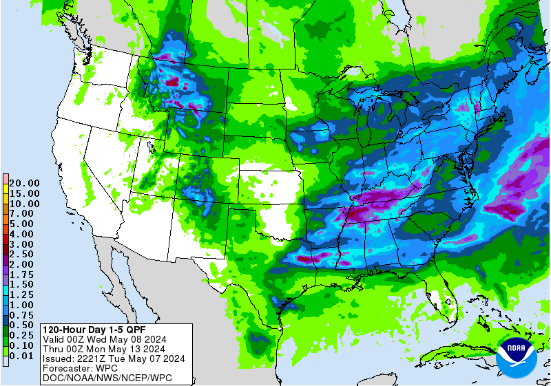
Here is a good indicator of the current impacts of the situation in the Gulf of Mexico and off the East Coast prior to any landfalls. It is the current atmospheric moisture load up to the midpoint in the atmosphere. As you can see, it is pretty substantial.

And here is a cumulative five day precipitation forecast.
Now to the Pacific Ocean.

This animation may actually provide a better view as in covering further west in the Pacific. It also shows the situation in the Gulf of Mexico also. It is not a forecast but a replay of the past 24 hours and it updates.

For the moment the situation with Madeline looks good and it is already impacting Hawaii which is why it is off the screen to the left. It has weakened considerably.
Area Forecast Discussion National Weather Service Honolulu HI 222 PM HST WED AUG 31 2016
UPDATE…Madeline has been downgraded from a hurricane to a tropical storm.
SYNOPSIS…
Tropical Storm Madeline will approach from the east today and pass near the Big Island later today and tonight. Madeline will depart to the west of the Big Island on Thursday and track south of the other islands through Thursday night, bringing a breezy to windy trade wind weather pattern to portions of state. The weather pattern over the weekend will be highly dependent on the track and intensity of Hurricane Lester. Once the effects of Lester exit the area, a typical trade wind weather pattern will return.
So Madeline would appear to be more or less a routine storm for Hawaii but the next in line may be much more dangerous.
Lester is a more significant threat and the information which will update can be found by clicking here.
As far as I know there is no track graphic that automatically updates so below is what the track was when I published and you can use the link in the sentence above to see the updated track and find much additional information.

But the link above will allow you to keep up to date on the progress of Lester.
And now a brief preview of the NOAA Update of their September Outlook which was issued today.
NOAA has, as usual, issued an update for the month following the last day of the prior month. This update was issued on August 31 and I am presenting the prior and updated graphics for comparison. I am not commenting on the changes tonight or presenting the short discussion that NOAA released with these graphics but I will do that this coming Monday.
Temperature
Prior Outlook Issued on August 18, 2016

Updated Temperature Outlook Issued on August 31, 2016

Precipitation
Prior Outlook Issued on August 18, 2016

Updated Outlook Issued on August 31


