9 February 2015 Weather and Climate Outlook – Let’s Consider the Possible Pacific Climate Shift.
Written by Sig Silber
Perhaps the first part of my report this week which focuses on possible Climate Shift in the Pacific is the most stable part of my weekly report. With respect to the NOAA short-term Outlooks, what a difference a week makes or even a day. There is no similarity in the precipitation outlook today as compared to the machine produced outlook yesterday. Who should we believe? Those who take coffee breaks or the computers which grind away with no amenities? It is kind of amazing how the models change their mind every six hours but the “Level of Confidence” is high because all the models are saying the same thing. To me, it is a unique way of defining level of confidence.

This is my weekly Weather and Climate Update Report. A more complete report can be found here in what I call Page II of my Weekly Report.
To understand climate one needs to understand:
- Secular trends such as Global Warming
- Major climate cycles
- Unusual events such as a volcanic eruption which can produce cooling for an extended period of time.
Global Warming is very important but we have a large number of scientists studying it and it is a topic that is of interest to the media so it is not likely to be ignored. But Global Warming does not proceed on a year by year basis at a predictable rate. We have on average a positive differential between solar energy reaching the Top of the Atmosphere (TOA) and the reflected or radiative energy escaping into outer space. The size of this imbalance is not very large but it is cumulative. It is in the range annually of about a half a watt per square meter out of perhaps 340 watts per square meter measured at the TOA. This creates what is called a secular warming trend. But the earth rotates and we have mountains and oceans. Thus for any spot on the Earth, the timeline of the path towards warmer is irregular until you analyze it and realize that it is following certain cyclical patterns which need to be superimposed on the secular warming trend to predict the path forward of temperatures as well as precipitation and other things that directly or indirectly result from or determine our climate.
Most cycles are pretty much orphans with respect to much of the academic community and do not captivate the public imagination. El Nino and La Nina which are phases of the ENSO Cycle are the notable exception to this. Most other cycles are rarely in the news and less than adequately integrated into weather forecasting models. And yet these cycles tend to have significant economic impacts because they impact different parts of the Earth differently at any one point in time and tend to be equal opportunity blessings or curses. The benefits they provide in one part of the World tend to be offset by misery somewhere else. So I have tried to focus attention on these cycles.
Currently an issue of great importance is whether or not the pattern of warmer areas versus colder areas in the Pacific has changed. Such changes are often referred to as a Pacific Climate Shift. There is some discussion that we may be either in a Pacific Climate Shift now or that one may be imminent. So that is the topic that I wish to discuss at the beginning of this week’s Weather and Climate Report.
Two weeks ago I referenced this article and this article which address this subject but did not discuss them. I thought I would need to discuss both but it turns out that the first link covers both the 1977 – 1998 Positive Phase of the PDO and the 1947 – 1976 Negative Phase of the PDO. So I will focus on just that first paper: “Tropical Pacific Forcing of a 1998–1999 Climate Shift: Observational Analysis and Climate Model Results for the Boreal Spring Season Bradfield Lyon, Anthony G. Barnston, David G. DeWitt”. What is very unusual is that these authors are addressing the Northern Hemisphere Spring/Southern Hemisphere Fall while most climate researchers focus on winter or summer. So this is unusual and thus to me especially interesting.
One complication in presenting this material is that I am most comfortable characterizing the condition of the Pacific using a particular index the Pacific Decadal Oscillation or PDO. The PDO refers to the Northern Hemisphere but there is a related index called the Interdecadal Pacific Oscillation (IPO) that covers both Hemispheres. As I discuss the Lyon et al. paper you will see that the authors do not rely on any of these indices to aggregate data for their graphics since basically their methodology recreates them. I am using the terms PDO and IPO in my discussion as do the authors in their article to provide a frame of reference that fits with other information I have presented.
Most of the findings in that paper that I want to discuss show up in the below graphic. Unfortunately, unless you have a color printer you need to view this on the screen. It is a very simple graphic really. The authors have removed the impact of Global Warming and the ENSO cycle. So they really are attempting to capture the impact on precipitation of the changes from one Pacific Ocean configuration to another. For purposes of relating the discussion to the U.S. I have taken the liberty in my comments to refer to the periods of time they are comparing as being periods which are considered to have been PDO Positive or PDO Negative. For certain readers a reference to the IPO would be perhaps more recognizable but the PDO and IPO are highly correlated. In the graphic the authors just display their data in terms of periods of time but those periods can be described by the PDO index and (as well as the IPO index) I have done that.
With respect to the below graphic,
Figure 4a compares precipitation since the PDO went Negative to the period of time (1977 – 1998) when it was Positive.
Figure 4b compares 1977-1998 with 1947-1976 the prior negative configuration of the Pacific.
So in both cases the goal is to compare a period of PDO positive with a period of PDO negative and since it is looking at the entire world, the IPO is used not the PDO. The IPO covers the entire Pacific not just the Northern Hemisphere. Again, the authors discuss the IPO but do not use it as part of their methodology as their methodology is the methodology used to define the IPO.
Figure 4c shows the part of the results which are statistically significant at the 10% level.
A value of this analysis is that it not unreasonable to anticipate the reversal of the colors on the chart 4c if the PDO has indeed gone positive. Recently, there have been very high readings of this index but I am not at all convinced that the climate shift has taken place and in fact I think it is too soon and that the recent high readings are a result of the near El Nino Modoki Type II in the Pacific. But that is speculation on my part since I think that most people who are knowledgeable about oceans cycles are fairly convinced that they are easier to identify after they occur than to predict. But a switch to PDO+ will occur sooner rather than later. In Part II of my report, there is a discussion which I presented I think two weeks ago perhaps earlier where I discuss the logical conclusion as to when the PDO will shift based on the work of some other researchers. I have also made my own assessment of when the Pacific will shift. My analysis is purely statistical and I arrive at an estimate of 5 – 20 years with perhaps 10 to 15 years being the most likely time for the next peak of the PDO Index. Some believe the shift has already begun.
It is important to remember that the PDO and IPO are oscillations not regular cycles and most likely represent three or more separate phenomena. The Aleutian Low may have its own cycle. The Kuroshio-Oyashio Extension (KOE) may exhibit cyclical behavior. ENSO is a well known cycle. Some of these cycles may be impacted by the AMO. There is a South Atlantic version of the AMO also. So the PDO and IPO may be a combination of cycles with different wavelengths. So a change in the Pacific may take many different forms and occur in an irregular manner. The below graphic shows the differences over a multi-year period. One could view the analysis by year and see how it is impacted by the ebb and flow of the situation in the Pacific but it would be difficult to interpret that amount of data so this approach is easier to interpret but we should recognize that the conditions in the Pacific are not binary but vary and not in a totally regular way.

The following is from the Summary and Conclusions Section of their paper:
“Observationally-based analyses and reanalysis products have been used to document a multidecadal shift in Pacific SSTs in 1998–1999 and associated atmospheric changes that are akin to the shift of 1976–1977. Emphasis is on the 3-month season of MAM, which has received only modest attention from previous investigators examining related multidecadal SST variations. The motivation for the study was to examine in greater detail the abrupt decline in MAM East African rainfall reported by LD that occurred in 1999 in order to view those results in a global domain and on multidecadal timescales. An EOF analysis of the residual anomalies of SSTs since 1900, determined by removing the (simultaneous) effect of ENSO and the global warming signal from the data by linear regression, revealed a loading pattern in the Pacific generally similar to the PDO. The associated PC time series shows a shift in 1999 indicative of, among other features, a change in the background state of Pacific SSTs towards cooler than average conditions in the east-central tropics. A composite difference of the full SST field in fact shows an average cooling of over 0.5 for the period 1999–2012 relative to 1977–1998 in that region. The PC time series of the residual SST EOF reveals earlier shifts in 1925, 1946 and 1976, which are all consistent with previously reported shifts in the PDO (e.g., Mantua et al. 1997)
As expected, the precipitation response to the 1999 shift in SST is large scale, with statistically significant changes in MAM season totals for the post-1998 period seen in multiple locations including drying over East Africa and central-southwest Asia, coastal regions of southeastern China, parts of northeastern Australia and the southwestern US. Drier conditions are also seen over the central Indian Ocean and the east-central Pacific Ocean. Wetter conditions include a zonally elongated band across the northern Indian Ocean extending from the eastern Arabian Sea eastward across southern India to the Philippines, the western tropical Pacific and northern South America. A southwestward displacement of the SPCZ is also identified.
Atmospheric circulation changes during MAM at 850 hPa [Editor’s note the following table may help in relating to Air Pressure levels. 850 hPa is generally used to look at frontal movements, 500 hPa (which is pretty much the average for half the air being below and half above this level of air pressure) is often considered a good way to look at steering currents and the area of about 250 hPa is where the Jet Stream tends to be most pronounced. These are all generalizations but useful and provide a way compare the findings of different researchers] associated with the recent shift are observed
in both hemispheres and include an anomalous anticyclonic circulation southeast of the Aleutians [Editors Note: Is this the RRR?], enhanced easterlies in the equatorial Pacific and subtropics in both hemispheres and anomalous westerlies across the northern Indian Ocean. This latter feature, also identified by LD, is consistent with an earlier onset of the South Asian monsoon in recent years (Kajikawa and Wang 2012; Xiang and Wang 2013 ), with Xiang and Wang (2013) suggesting it is forced by Rossby waves emanating from the anomalous rainfall in the western tropical Pacific. Near-surface wind changes in the tropical Pacific are generally similar to those reported by Hu et al. (2013). The PC time series associated with a joint EOF analysis of the anomalous 850 hPa wind components in 20CR going back to 1930 indicates a similar circulation pattern was present during the previous Pacific cool phase over the northern Indian Ocean, further supporting the notion of a decadal modulation of South Asian summer monsoon onset. At 200 hPa, anomalous stationary wave features included a PNA-like pattern in the northern hemisphere, with suggested wave propagation from the east-central Pacific region into the southern hemisphere as well. An anomalous wave train emanating from the western tropical Pacific into both hemispheres is also identified, most likely forced by the anomalous rainfall and associated diabatic heating in the western tropical Pacific. The PC time series associated with the EOF analyses of both the 850 hPa wind field and 200 hPa anomalous stationary waves both show an abrupt and statistically significant shift in 1999 in R2. [Editor’s note: R2 refers to a particular data series]
Model simulations using the ECHAM4.5 atmospheric general circulation model forced with globally observed SSTs (‘‘full simulation’’) generally capture most of the observed precipitation and atmospheric circulation features associated with the recent shift. While both the full and POGA simulations tended to show greater interannual variability associated with ENSO than in observations during the post-1998 period, based on an EOF analysis both sets of model experiments also produced a statistically significant shift during 1999 that is consistent with observations. POGA runs of the ECHAM4.5 forced with observed SSTs only in the tropical Pacific were also able to capture most of the main features associated with the recent shift and generated more realistic precipitation changes over the northern Indian Ocean and southern Africa compared with the full simulations. This result points to the fundamental role played by the tropical Pacific in forcing the observed atmospheric conditions, which is consistent with the conclusions drawn by previous studies examining the 1976–1977 shift (e.g., Graham 1994; Trenberth and Hurrell 1994; Deser et al. 2004).
Overall this study has documented a recent shift in Pacific SSTs, its connection with multidecadal variability and its influence on regional climate changes around the globe during the MAM season. While the SST loading pattern identified in the EOF analysis of the residual SST field (i.e., after linearly removing ENSO and the global warming signal) resembles the behavior of the PDO, emphasis is not placed here on strict definitions of low frequency patterns of Pacific SSTs. The results presented would also map onto the interdecadal Pacific Oscillation (IPO) as described by Power et al. (1999), for example. And regardless of the analysis method used to identify it, we do not address the issue of causality of the observed, multidecadal variability and the recent associated shift. Causality is a fundamental question that goes beyond the scope of this study, with multiple hypotheses put forward in the scientific literature. On the one hand, a null hypothesis positing that such variability can be explained as red noise processes alone [Editor’s Note: I believe this is the way climatologists describe Brownian Noise i.e. randomness – in a very loose way], including the reddening of the ENSO signal (Newman et al. 2003) has been advanced, while alternatively, various physical mechanisms have also been suggested, many contained in the recent review by Liu (2012). From a practical perspective, however, there is useful information in recognizing that the recent shift has occurred, having consequences for regional precipitation variability in several regions of the globe.
As the original motivation for the study was to examine in greater detail the abrupt decline in MAM East African rainfall in 1999, here the observational evidence, climate model full simulations and POGA run experiments all support the conclusion that this recent decline is directly related to multidecadal Pacific SST variability, with the forcing coming from the tropical Pacific. More generally, further work is needed to elucidate the physical mechanisms at work in generating the regional climate variations that have occurred around the globe during the post-1998 period.”

Short-term Outlook
Let us take a look at the 8 – 14 day outlook that was issued today February 9, 2015. It will auto-update every day so it will be changing day by day (and thus be up to date whenever you elect to read this report) but my comments may become out of sync with the map since my comments do not auto-update.
Generally I only show the “second week” namely the day 8 -14 outlook. The first week together with much additional information on current weather patterns and near-term forecasts can be found in Part II of my report, but 8 – 14 days covers most of the 6 – 14 day period. However for today I am also showing the 6 – 10 Precipitation Outlook and both the one issued today and the one issued by the computers yesterday i.e. Sunday.
Here is the updated Temperature Outlook Issued Saturday January 31.

And here is the 8 – 14 Day Temperature Outlook.

The 8 – 14 Day Temperature Outlook is consistent with the Monthly Outlook but more intense.
Here is the updated February Precipitation Outlook Issued on January 31, 2015

And here is the 8 – 14 Day Precipitation Outlook issued today February 9, 2015.

But take a look at the 6 – 10 day Precipitation Outlook issued on Sunday.
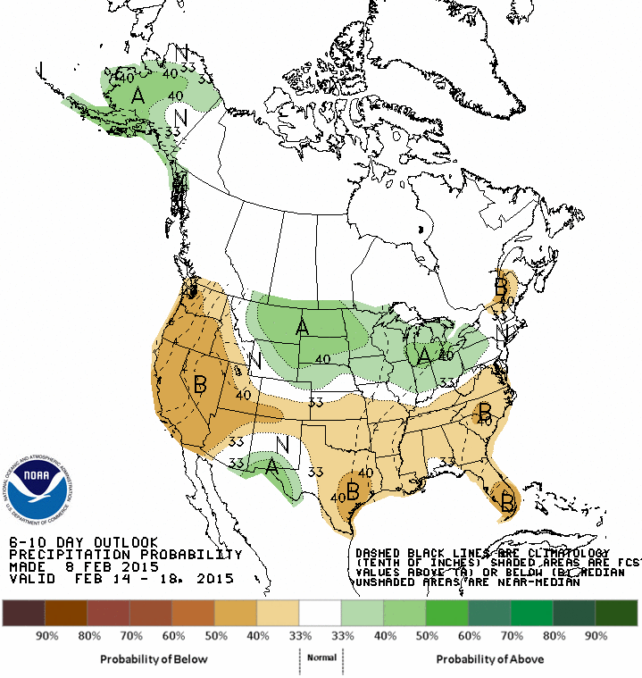
And here is the updated version of the 6-10 Day Precipitation Outlook issued today February 9, 2015.

This is both a big change from the perspective of NOAA (or at least their computers yesterday) and is a major change from their perspective last week and indicates a major shift taking place which they had predicted but it looks like this shift may be occurring earlier than they had anticipated as recently as yesterday. If you put all the information together you can tell that there is a change predicted for Thursday February 19. We will see how that works out.
The Precipitation Outlook for the first half of February clearly does not appear to be developing according to the February Outlook. It is only part of the month but February is a short month. Sometimes however the Monthly Outlook turns out to be correct even if it always looks different than the 6 – 14 Day Outlook. This occurs when there is a mid-month shift. The February Outlook issued on January 31 dropped El Nino in favor of a more neutral stance re ENSO. I do think however that the perspective of NOAA has changed since their January 31 Update for February and they explained some of the reasons last Friday and I have included that discussion following the excerpts from the NOAA discussion released today covering the February 9, 2015 6 – 14 Day Outlook. Some of the highlighted areas reflect the earlier discussion of the Aleutian Low.
“6-10 DAY OUTLOOK FOR FEB 15 – 19 2015
TODAY’S ENSEMBLE MEAN AND DETERMINISTIC SOLUTIONS ARE IN GOOD AGREEMENT ON THE 500-HPA MEAN CIRCULATION PATTERN FORECAST OVER MOST OF THE NORTH AMERICA DOMAIN FOR THE 6-10 DAY PERIOD. A DEEP TROUGH IS EXPECTED OVER THE NORTH PACIFIC OCEAN. AN AMPLIFIED RIDGE IS PREDICTED NEAR THE WEST COAST OF NORTH AMERICA FROM NORTHERN CALIFORNIA TO ALASKA, AND ANOTHER DEEP TROUGH IS FORECAST ACROSS THE EASTERN CONUS. A WEAK TROUGH IS FORECAST SOUTH OF CALIFORNIA. THE MANUAL BLEND CHART INDICATES ABOVE NORMAL HEIGHTS OVER ALASKA AND THE WESTERN CONUS AND BELOW NORMAL HEIGHTS OVER THE EASTERN CONUS. THE ENSEMBLE SPAGHETTI DIAGRAMS INDICATE MODERATE SPREAD ACROSS THE MAJORITY OF THE FORECAST DOMAIN.
THERE ARE ENHANCED ODDS FOR BELOW-NORMAL MEAN TEMPERATURES OVER THE EASTERN CONUS, DUE TO THE EXPECTED PROXIMITY OF THE 500-HPA TROUGH, BELOW-NORMAL 500-HPA HEIGHTS, AND NORTHERLY ANOMALOUS FLOW. ABOVE-NORMAL 500-HPA HEIGHTS ASSOCIATED WITH THE RIDGE ANTICIPATED OVER MOST OF ALASKA AND WESTERN NORTH AMERICA FAVOR ABOVE-NORMAL TEMPERATURES FOR THE WESTERN CONUS AND ALASKA.
BELOW-MEDIAN PRECIPITATION IS FAVORED FOR THE PACIFIC NORTHWEST AND EASTERN ALASKA. THIS IS DUE MOSTLY TO THE FORECAST PRESENCE OF A 500-HPA RIDGE AND/OR NORTHERLY ANOMALOUS FLOW. TROUGHING OVER THE NORTH PACIFIC OCEAN AND/OR SOUTHERLY ANOMALOUS FLOW ENHANCES CHANCES OF ABOVE-MEDIAN PRECIPITATION AMOUNTS FOR WESTERN ALASKA. BELOW-MEDIAN PRECIPITATION IS FAVORED FOR FLORIDA AND NEW ENGLAND, WHILE INCREASED CHANCES OF ABOVE-MEDIAN PRECIPITATION IS FORECAST ACROSS THE SOUTHWEST, SOUTHERN AND CENTRAL ROCKIES, MUCH OF THE GREAT PLAINS, PARTS OF THE MISSISSIPPI VALLEY, AND THE OHIO AND TENNESSEE VALLEYS, CONSISTENT WITH NAEFS AND GEFS REFORECAST GUIDANCE.
FORECAST CONFIDENCE FOR THE 6-10 DAY PERIOD: ABOVE AVERAGE, 4 OUT OF 5, DUE TO GOOD AGREEMENT AMONG THE MODELS.
8-14 DAY OUTLOOK FOR FEB 17 – 23 2015
TODAY’S ENSEMBLE MEAN AND DETERMINISTIC SOLUTIONS ARE IN GOOD AGREEMENT ON THE 500-HPA MEAN CIRCULATION PATTERN FORECAST OVER MOST OF THE NORTH AMERICA DOMAIN FOR THE WEEK-2 PERIOD. THE PREDICTED CIRCULATION PATTERN IS SIMILAR TO THAT EXPECTED FOR THE 6-10 DAY PERIOD. A WEAK TROUGH IS ALSO FORECAST ACROSS THE SOUTHWESTERN CONUS/NORTHWESTERN MEXICO. THE ENSEMBLE SPAGHETTI DIAGRAMS INDICATE MODERATE SPREAD ACROSS THE MAJORITY OF THE FORECAST DOMAIN.
THE EXPECTED TEMPERATURE AND PRECIPITATION ANOMALY PATTERNS FOR WEEK-2 ARE SIMILAR TO THOSE PREDICTED FOR DAYS 6-10. THERE ARE ENHANCED ODDS FOR BELOW-NORMAL MEAN TEMPERATURES OVER THE EASTERN CONUS WHILE ABOVE-NORMAL TEMPERATURES ARE FAVORED FOR THE WESTERN CONUS AND ALASKA. NEAR TO BELOW-MEDIAN PRECIPITATION IS FAVORED FOR ALASKA, WHILE NEAR TO ABOVE ABOVE-MEDIAN PRECIPITATION IS FORECAST FOR THE CONUS, CONSISTENT WITH NAEFS AND GEFS REFORECAST GUIDANCE.
FORECAST CONFIDENCE FOR THE 8-14 DAY PERIOD IS: ABOVE AVERAGE, 4 OUT OF 5, DUE TO GOOD AGREEMENT AMONG THE MODELS.“
Here is an excerpt from the Friday discussion which I have included because it provides a clearer explanation of what NOAA sees as what is going on.
THE HIGHLY AMPLIFIED RIDGE-TROUGH PATTERN OVER MOST OF NORTH AMERICA HAS BEEN VERY STABLE OVER THE PAST MONTH (WITH ONLY ONE BRIEF EXCEPTION), AND IS FORECAST TO REMAIN STABLE THROUGH AT LEAST THE WEEK-2 PERIOD. THOUGH THIS AMPLIFIED FLOW PATTERN IS A VARIATION OF THE POSITIVE PACIFIC-NORTH AMERICA (PNA) TELECONNECTION, IT IS NOT THE CLASSIC SETUP. THE LOADING PATTERN/CANONICAL CONFIGURATION FEATURES NEGATIVE 500-HPA HEIGHT ANOMALY CENTERS NEAR THE ALEUTIANS AND THE SOUTHEAST CONUS, AND A POSITIVE HEIGHT ANOMALY CENTER NEAR BRITISH COLUMBIA. THE PREDICTED PATTERN DEPICTS NEGATIVE HEIGHT ANOMALY CENTERS OVER THE CENTRAL PACIFIC (35-40N/160W) AND NEAR THE GULF OF MAINE, THOUGH THE POSITIVE ANOMALY CENTER IS CLOSE TO THE CANONICAL LOCATION NEAR BRITISH COLUMBIA. AN IMPORTANT DIFFERENCE BETWEEN THESE TWO PATTERNS IS THE LOCATION OF THE NEGATIVE ANOMALY CENTER OVER THE EASTERN CONUS. WITH THE CLASSIC POSITIVE PNA CONFIGURATION, THERE ARE OPPORTUNITIES FOR WINTER STORMS TO AFFECT THE EASTERN SEABOARD, IN PARTICULAR THE NORTHEAST. THE FLOW PATTERN THAT IS CURRENTLY PREDICTED, HOWEVER, SUGGESTS THE STORM TRACK WILL BE SHIFTED WELL EAST OF THE ATLANTIC COAST.
THERE ARE ENHANCED ODDS FOR BELOW-NORMAL MEAN TEMPERATURES OVER THE EASTERN CONUS AND NORTHWESTERN ALASKA, DUE TO THE EXPECTED PROXIMITY OF 500-HPA TROUGHS AND/OR BELOW-NORMAL 500-HPA HEIGHTS AND NORTHERLY ANOMALOUS FLOW. THE AREA OF FAVORED BELOW-NORMAL MEAN TEMPERATURES ACROSS SOUTHERN TEXAS IS DUE TO THE EXPECTATION OF ABOVE-MEDIAN PRECIPITATION AND EASTERLY ANOMALOUS FLOW. ABOVE-NORMAL 500-HPA HEIGHTS ASSOCIATED WITH THE RIDGE ANTICIPATED OVER MOST OF WESTERN NORTH AMERICA FAVORS ABOVE-NORMAL TEMPERATURES FOR THE WESTERN CONUS AND SOUTHERN ALASKA.
BELOW-MEDIAN PRECIPITATION IS FAVORED FOR THE WEST COAST, NORTHERN AND CENTRAL PORTIONS OF BOTH THE INTERMOUNTAIN REGION AND ROCKIES, THE NORTHERN AND CENTRAL PLAINS, MOST OF THE MISSISSIPPI VALLEY AND SOUTHEAST, AND THE MID-ATLANTIC REGION. THIS IS DUE MOSTLY TO THE FORECAST PRESENCE OF A 500-HPA RIDGE AND/OR NORTHERLY ANOMALOUS FLOW. THERE ARE ELEVATED ODDS OF ABOVE-MEDIAN PRECIPITATION FROM EASTERN ARIZONA TO CENTRAL TEXAS, AND MOST OF ALASKA. THESE AREAS ARE ATTRIBUTED TO THE ANTICIPATED PRESENCE OF UPSTREAM 500-HPA TROUGHS AND/OR SOUTHERLY ANOMALOUS FLOW.
Analogs to Current Conditions
Now let us take a detailed look at the “Analogs” which NOAA provides related to the 5 day period centered on 3 days ago and the 7 day period centered on 4 days ago. “Analog” means that the weather pattern then resembles the recent weather pattern and was used in some way to predict the 6 – 14 day Outlook.
Here are today’s analogs in chronological order although this information is also available with the analog dates listed by the level of correlation. I find the chronological order easier for me to work with. There is a second set of analogs associated with the outlook but I have not been analyzing this second set of information. This first set applies to the 5 and 7 day observed pattern prior to today. The second set which I am not using relates to the forecasted outlook 6 – 10 days out to similar patterns that have occurred in the past during the dates covered by the 6 – 10 Day Outlook. That may also be useful information but they put this set of analogs in the discussion with the other set available by a link so I am assuming that this set of analogs is the most meaningful. On a spot-check basis, I see less overlap between the prior and projected analogs (adjusted for the differential in timing than I would expect), but so far I have not examined that.
Analog Centered Day | ENSO Phase | PDO | AMO | Other Comments |
| 1954 January 28 | El Nino | – | + | Immediately followed by La Nina |
| 1963 February 3 | Neutral | – | + | El Nino the following winter |
| 1982 February 14 | Neutral | + | – | Strong El Nino the following winter |
| 1991 January 31 | Neutral | – | – | El Nino the following winter |
| 1991 February 1 | Neutral | – | – | El Nino the following winter |
| 1995 February 17 | El Nino | + | – | A Modoki soon followed by a La Nina |
| 1997 January 27 | Neutral | + | – | Prior to a very strong El Nino |
Generally, the analogs are indicating ENSO Neutral but are very inconsistent including the phases of the PDO and AMO. This variability reduces my confidence in the 6 – 14 Day Outlook. The mention of 1997 is always of great interest because the following winter was a very strong El Nino and the following two years were when the Pacific shifted from its positive configuration to PDO negative.
Back to the Current Situation:
Sometimes it is useful to take a look at the location of the Jet Stream or Jet Streams.

And sometimes the forecast is revealing. Below is the forecast out five days. It shows how how the weather pattern has been shifted to the north not south as is the case with a traditional El Nino. It is also being shifted east. I know some will think I am daffy but to me the pattern looks a bit like a summer monsoonal pattern for the Southwest. The logic there is the persistent warming of the West or at least persistent temperatures warmer than climatology.

To see it in animation, click here.
This longer animation shows how the jet stream is crossing the Pacific and when it reaches the U.S. West Coast is going every which way. One can imagine that attempting to forecast this 6 – 14 days out is quite challenging.
And below is another view which highlights the surface highs and the lows re air pressure on Day 3. You can see how the counter-clockwise Aleutian Low is funneling warm wet air towards the Alaskan Panhandle and the Lower 48 Northwest. The RRR is clearly evident.

And here is Day 6

It is starting to look a bit different. Notice the low pressure system off the East Coast. Also the low off of Baja California.
El Niño Discussion
Now let us look at the latest NOAA Hovmoellers. I had hoped that we might be able to stop looking at these Hovmoellers this winter if I concluded that it really is a done deal….ImagiNiño: end of story. But I tend to think that we will have to go through this analysis until at least February 19 when the next NOAA Seasonal Outlook is released. More than likely we will be tracking ENSO for a long time as what might not be happening this winter may happen next winter which begins later this year. Winters in the Northern Hemisphere have their onset late in one calendar year and exend into the next.
There are many graphics that NOAA provides every Monday but I focus on a subset of the information provided and today I thought I would again start with what probably is the most important one that I call the Kelvin Wave graphic but it is really the Upper Ocean Heat Anomaly along the Equator which is caused in many cases primarily by Kelvin Waves.

There is not much change since last week. The upwelling phase now even more clearly shows a cooling anomaly as it moves east but it is about to play out. The next downwelling Kelvin Wave was declared last week and its existence presumably impacts the forecast models. But history tells us that El Nino events develop prior to Christmas which is how they got their name. An ONI greater than 0.5 in March and April is interesting but not necessarily as significant as an ONI greater than 0.5 in December. I do not have a real scientific basis for saying this but I think that this Kelvin wave will play out to the west of the recent Kelvin waves and have less impact. You can compare them from top to bottom and draw your own conclusions. Remember this graphic is showing anomalies.
Now let us look at the Sea Surface Temperatures

Again there is some change since last week as you can see even less warm water along the Equator. Actually it is a cool water anomaly now. You can also see the impact west of the Date Line of the new downwelling Kelvin wave.

Of most interest to NOAA is 120 W to 170 W as that is where the ONI Index is measured. More information can be found here. If you look at the color coding in the above Hovmoeller they are looking for shades where the redder the better re conditions being El Nino but so far it is just showing shades of tan and brown i.e. marginal especially when averaged over the entire area of interest. But that explains why we have a situation where some of the factors are in place for an El Nino but so far it is marginal at best and fading fast.
And now the low-level wind anomalies.

This shows not much change from last week. We still see the strong wind anomaly west of the Date Line. The Southern Oscillation Index (SOI) was very strong two weeks ago and had some ability to revitalize the “ImagiNiño”. But this week it is clearly consistent with ENSO Neutral. You can find the daily and 30 and 90 day averages here. The 30 day average of -10.3 is consistent with El Nino conditions (a 30 day average of -8.0 or more negative is considered to be consistent with El Nino conditions) but the 30 average is as low as it is due to four days of very low SOI readings two weeks ago which most likely was due to local conditions at either Tahiti or Darwin Australia. Today’s reading of -2.1 is consistent with ENSO neutral conditions. The SOI fluctuates based on local weather conditions in Tahiti and Darwin Australia so one week of data let alone four days is not sufficient to draw any conclusions but it impacts the Hovmoellers and the computer models. The 90 day average is currently -7.1 which is not sufficiently negative to be considered consistent with El Nino conditions but it is not off by much. All of this is like a broken record repeating: “almost an El Nino but not quite and possibly not a traditional version”.
3 Feb 2015 -5.50
4 Feb 2015 -3.80
5 Feb 2015 -1.0
6 Feb 2015 -6.0
7 Feb 2015 -7.6
8 Feb 2015 -3.7
9 Feb 2015 -2.1
And finally the latest model results released by NOAA on February 9, 2015.

This graphic is a modified version of the graphic that appears on Page II of this Report. It is modified by NOAA to be consistent with the maps on the right which can be found here. Those maps have been processed to adjust for the observed skill of the models. I probably could do a better job with triangles but just by eyeballing this chart it looks like it is showing an ONI reading of about 0.6 to 0.7 forecast through the Spring. If that was your only criteria, this would be considered a marginal El Nino but the other factors have not fallen into place. And this model does not attempt to classify the type of El Nino which is very important in terms of weather impacts.
Below is another graphic that confirms that we are not in a traditional El Nino but perhaps a borderline El Nino Modoki. The top graphic shows surface temperatures and wind direction and speed conditions 10 degrees north to 10 degrees south of the Equator and this is one of the most up to date sources of information available. The bottom graphic shows anomalies.The bottom graphic shows the deviation from average conditions. You can see many things in this graphic. First of all you can see the pockets of warm water which are in some cases greater than 1C above average and in other cases below 0.5C above average conditions. West of 170W in the Nino 4 area you have warm water on the Equator which is consistent with a Modoki Type II. Looking between 170W and 120W on the Equator, you see an area where the anomaly is under 0.5C which has increased somewhat since last week. And you also see an area above 0.5C which has increased in size. In the Nino 1+2 Area over by Ecuador, one can see a positive anomaly i.e.colder water. That does not figure in to the ONI calculation but determines the type of El Nino that we have and the impact it has on weather. Also the anomaly analysis of the winds generally point to the North with small anomaly arrows indicating little if any diminishment of the prevailing Easterlies east of the Date Line (180 degrees Longitude) which to me is another indication that this might be more like a Modoki than a canonical/traditional El Nino. Not shown here but the warm water off the Northeast Coast of the U.S. is also consistent with a Modoki Type II.

Pulling it All Together. .
So this continues to look to me like a warm event that is not a full fledged El Nino and is not a traditional El Nino. So the expected impacts are different than the expected impacts from a traditional El Nino. Whatever this pattern is, it is not very different from ENSO Neutral. I am still thinking the Japanese sized this up from the start and that this is really more like a Modoki than a traditional El Nino and that weather patterns are shifted some number of degrees further west (or possibly rotated) than would be the case for a traditional El Nino which is why the weather where I live is more typical of a La Nina than an El Nino. This has been the case since the PDO went into its Negative Phase in 1998/1999 which is why a possible change to PDO Positive is so very important.
I do not see a traditional El Nino of any significant strength likely to happen this winter although a “near” El Nino appeared in January to be making its presence known to a limited extent but mainly outside of the U.S. That no longer appears to be the case in February. It remains a very complicated situation mostly because of the at least temporary shift of the configuration of the Pacific with respect to the location of warm and cold water to a configuration which is called PDO Positive (+) combined with the Blocking Ridge off the West Coast.
An El Nino Watch for next year might be in order as there remains a lot of warm water but usually it takes a few years for that to built up sufficient for another warm event to get under way. ENSO neutral is where the models are headed and I suspect that they have it correct.
Click Here for the Econointersect Weather and Climate Page II where you will find:
- A more complete set of NOAA and other agency graphics (including international agencies) that auto update. So this includes both short term- and seasonal “updates”. It will ALWAYS be up to date even if my commentary on the graphics is not. I update my commentary when it seems necessary and certainly every Monday but some of these graphics auto update every six hours.
- Economic and other Impacts of major weather events. Not sure there is any other place to obtain this information consistently other than very specialized subscription services.
- Information on Climate Cycles both those which are fairly short term i.e. less than a decade in duration and multi-decadal cycles.
- Economic and other Impacts of those Climate Cycles which are referred to by the IPCC as Internal Variability as opposed to secular Climate Change which is always in the same direction. Again I am not sure if there is another source for this information where it is pulled together in one place as I have.
Click Here for Page III which deals with Global Warming.
- Information on Anthropogenic Global Warming science i.e. the secular change in our climate that overlays both short-term weather and historical climate cycles as well as black swan events like volcanic eruptions. I prefer to call this Global Warming as it is the warming that triggers the other changes.
- Economic and other Impacts of Global Warming. The IPCC AR5 WG2 attempts to describe and quantify these and I have some excerpts from their report. Over time I will go beyond their report.


