
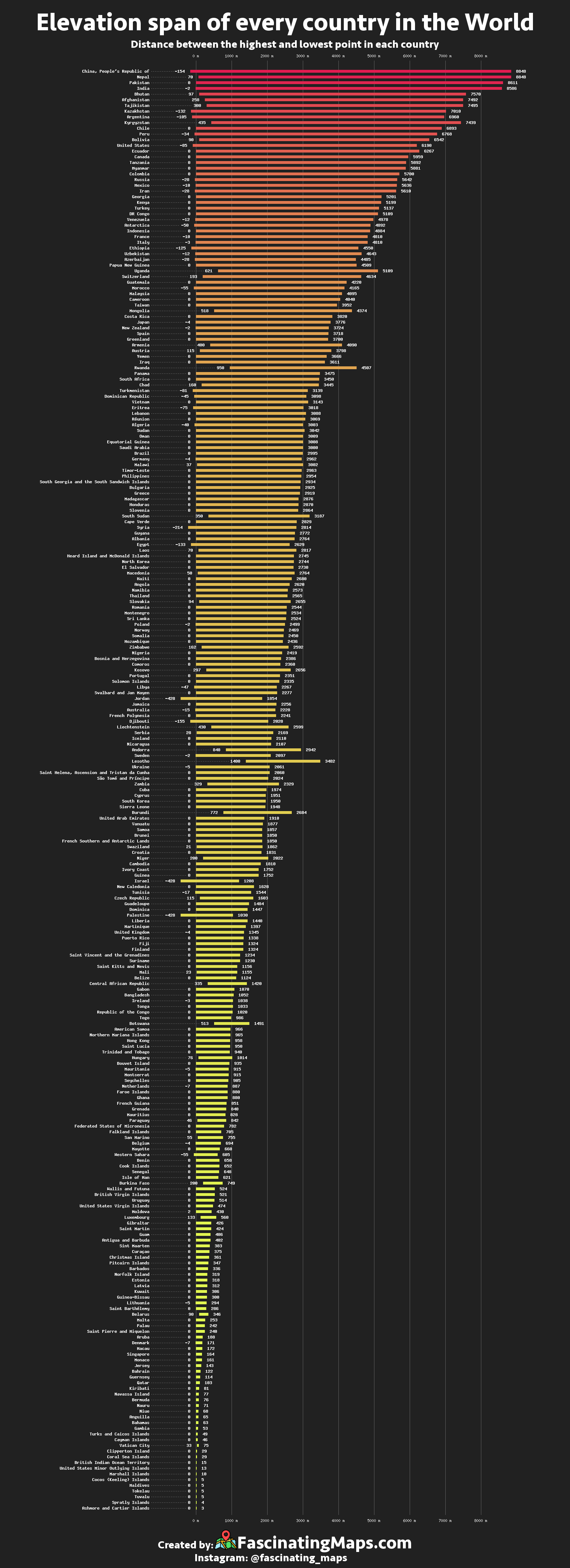
Today’s data visualization is a global breakdown of every country’s elevation span, from the severe mountain peaks that dominate Bhutan’s landscape, to the sweltering Dead Sea depression that runs along the Israel-Jordan border.

In the Indian Ocean, ringed by protective barriers, lies the island city of Malé – the capital of the Maldives. Malé has a thriving tourism industry and is one of the most urbanized islands in the world, but it has one major problem: its elevation (or lack thereof).
Over 80% of the nation’s landmass is below 3.3 ft (1m), leaving it acutely vulnerable to the impacts of climate change. If sea levels continue to rise, the entire chain of islands, including the homes of half a million people, could be submerged in as soon as 30 years.
Breaking out the measuring stick
By looking at the data, we see interesting patterns and unique situations emerge.
The Power of Zero: The median low-end land elevation of the world’s countries is zero. This is because shoreline typically makes up the lowest portion of a country’s terra firma. It’s easy to spot a landlocked country in the data set, as its lowest elevation is far more likely to be above sea level.
The Lowlands: In general, the smallest countries tend to have the smallest elevation spans, but some countries buck that trend. Denmark, which has a respectable 16,577 quare miles (42,933 sq. km) of land, has an elevation range of only 583 ft (178m). This means the highest point in the country is only 50m taller than its tallest building, Herlev Hospital, near Copenhagen.
The Highlands: Three countries – Nepal, Tajikistan, and Bhutan – have an average elevation that soars above 10,000 ft (3,050m). The latter country has the highest average elevation in the world.
Source: https://fascinatingmaps.com/elevation-span-of-every-country-in-the-world/


