Written by Sig Silber
U.S. and World Agriculture: Plus an Expanded Weather Forecast Section
Updated at 4:30 p.m. EDT May 24, 2019 to reflect the updated Week 3 – 4 Forecast which is not much changed.
The crop progress reports again range from bad to very bad. There is increasingly more detailed information available on what seems to be a bad crop year shaping up. In the Intermediate Term, the West is forecast to be mostly cool and wet except for the West Coast and Northwest. The Southeast is forecast to be mostly warm and initially dry so we might see some signs of increasing mild drought and dry soil in the Southeast over the next couple of weeks. But more of CONUS is in the cool and wet pattern than the dry and warm pattern. But the confidence level of the forecast is declining. We have the April International Weather Summaries and show some of them in the report but there is a link to all of them.

Please share this article – Go to the very top of the page, right-hand side, for social media buttons.
It is important to understand that the impact of weather on economic activity varies from one place to another. In this article, we try to provide a broad view of the impacts focusing mostly on the U.S. but also to a lesser extent on the Rest of the World. |
Major Sources of Information Used in this Weekly Report
|
1. Special Reports and Highlights.
Drought Progress
With the elimination of D2 from New Mexico, this week is the first time in the history of the USDM that the CONUS has been free of Severe to Exceptional Drought. However, it also marks the first time that Extreme Drought (D3) has been analyzed for Alaska.
Severe Weather

And more recently

We provide the usual three Snotel graphics later but this format is very impressive.
 You can

I do not have a similar graphic for Lake Mead but one can tell the situation from this report..for which updates are available here.


Looking Ahead re Agriculture: Field Work
| Last Week | This Week |
|  |

2. Summary of Intermediate-Term Weather Forecast (helpful to predict drought and floods etc)
Here is the summary of the forecast for the next approximately twenty-five days. We provide this so that we can make our own assessment of the drought forecast. Here I provide the weather forecasts for different periods of time in which should allow the reader to assess the likelihood of this forecast working out as shown over the next three to four weeks. Since we publish this week on Thursday, we generally update the discussion for the Week 3 – 4 forecast when it is updated on Friday. This is important as the current Day 6 – 14 forecasts and the week-old week 3 – 4 forecast overlap to some extent.
Later we provide additional information relative to the weather forecast analysis but here is the summary.
First Temperature
|
|
|
|
The graphic above shows magnitude rather than the probability of being higher or lower than Normal and shows the middle day of the five day period. | Overall the pattern for both Week – 1 and Week – 2 is a cool west and warm east. But for Week – 2, the cool anomaly changes to Normal. That is a recent change in the forecast. The transition from the 8 – 14 day forecast shown above to the week 3/4 forecast seemed feasible but a bit unlikely re the cool anomaly. However, the week 3-4 graphic was updated on May 24, 2019 and the cool anomaly is still shown. And the warm anomaly is still shown so that is not good for either the Northwest or the Northeast. | ||


And then Precipitation
|
|
| |
The five-day QPF is shown above. The units are different than the other maps i.e. in units of precipitation (inches) not probabilities of exceeding or being less than climatology. | Fairly stagnant but the Western wet anomaly is deamplifying slightly and the East looks mostly dry south of the Northeast in Week – 1. That is not good for the Southeast. The transition from the 8 -14 day forecast shown above to the week 3/4 forecast did not seem likely for the Eastern Half of CONUS. but the week 3-4 graphic updated on May 24, 2019 and the Southeast dry anomaly is still shown which is not the best news for either the Northwest or Southeast. | ||


Here is the discussion released on Friday with the Week 3 – 4 Update. They did not say but I do not think the level of confidence in this forecast is very high.
Week 3-4 Forecast Discussion Valid Sat Jun 08 2019-Fri Jun 21 2019
Weak EL Nino conditions currently are present across the equatorial Pacific Ocean. Equatorial sea surface temperatures (SSTs) are above average across most of the Pacific Ocean. The RMM MJO index indicates that the MJO propagated eastward across the West Pacific and the signal has become quasi-stationary during the past week. The GEFS forecast of the RMM index depicts the MJO signal to continue a slow eastward propagation over the Western Hemisphere while maintaining amplitude during Week-1. The Week 3-4 Outlook is based primarily on dynamical model forecasts, including the NCEP CFS, ECMWF and JMA ensemble prediction systems, as well as the Subseasonal Experiment (SubX), a multi-model ensemble (MME) of both operational and experimental ensemble prediction systems. Statistical forecasts, including a multivariate linear regression (MLR) of lagged temperature and precipitation forecasts to current observed MJO and ENSO indices, were also consulted. Decadal timescale temperature trends are also a source of predictability in both dynamical and statistical forecast tools.
Dynamical model guidance from the various models is broadly consistent, depicting a ridge over Alaska and western Canada, and a trough near the west coast of the CONUS. Dynamical model ensembles from the CFS and ECMWF favor near to above normal 500-hPa heights over the western CONUS, while JMA indicates negative 500-hPa height anomalies over the western CONUS. The CFS, ECMWF, and JMA show near normal 500-hPa heights over Hawaii.
The Week 3-4 Outlook indicates enhanced probabilities of above normal temperatures over the west coast of the CONUS, the Pacific Northwest, Arizona, and parts of the southeastern CONUS, while below normal temperatures are forecast over the central CONUS, consistent with the CFS/ECMWF/JMA Correlation Weighted and SubX forecasts. Above normal temperatures are most likely for Alaska under predicted positive 500-hPa height anomalies and where decadal temperature trends are relatively strong.
The Week 3-4 Outlook indicates likely above normal precipitation for parts of the Southern Plains and Southern Rockies into parts of the Central Rockies and the Central Plains as well as parts of the Northern Rockies, supported by most of the dynamical model forecasts. Near to below median precipitation is more likely for most of the eastern CONUS, consistent with the CFS/ECMWF/JMA Correlation Weighted and SubX forecasts. Below normal precipitation is also likely for much of mainland Alaska and the Alaska Panhandle and the Pacific Northwest under predicted above average 500-hPa heights.
Surrounding above average sea surface temperatures near Hawaii lead to enhanced probabilities of above normal temperatures for the Week 3-4 Outlook. A consensus of the SubX dynamical models predicts likely near normal precipitation for the northwestern Hawaiian Island and above normal precipitation for the southeastern islands.
Additional Information on the forecast is provided later.
3. Present Drought Conditions
The U.S. Drought Monitor is a comprehensive way of understanding the drought situation for the U.S. It is issued every Thursday and reflects the conditions as of the prior Tuesday. Drought is defined as a moisture deficit bad enough to have social, environmental or economic effects. Thus, more factors than recent precipitation are considered and more information on how it is done is found at the end of this report.

Something relatively new and concerns an area that is in drought probably due to the El Nino. This part of the world generally requires two inches of rain per week to avoid drought. You can see that about 8N is the dividing line between Moderate to no Drought and Severe to Exceptional Drought.

Below is the map for just CONUS and with statistics and below that map I have provided a cut-out of the statistics which I think you can click on to enlarge. When you click on graphics that I have set up to enlarge often with your mouse right click and then click on “view image” and that will work.
 |
 |
| Last Week | This Week |
| |

The graphic below shows the one-week change in drought intensity. Yellow is bad. Green is good.
|

Now we show the week to week change information by region. The yellow is where the drought has been upgraded. The green is where the level of drought has been downgraded.
 |
Improvement in Colorado. Not sure why Colorado shows up in two maps. Deterioration in North Dakota. |
 |
| Some deterioration in Minnesota |
 |
| No Change |
 |
Some deterioration in Texas and also Mississippi and Tennessee. |
 |
| Deterioration in all the Southeast states other than North Carolina and Florida. |
 |
Deterioration in Washington State and a small part of Oregon. Improvement in Colorado and New Mexico and even a small area along the Arizona/Utah border. |
I do not think it is useful right now to think in terms of a core drought area so I am not on a regular basis including some of the graphics we have been showing that focused on the West and the Four Corners Area in particular. But we included one of those graphics in the Special Reports and Highlights Section.
Some may find this way of looking at things useful and I hope these graphics are not too small to read. I did not make them so you could click on them individually but you can click on the whole graphic and it may enlarge. But I think you get the picture. It has been a rapid onset and demise. When you read these graphics, remember that the older graphics are not the drought conditions that existed then but the change from then until now.

Some might find this animation of twelve weeks of change useful;

Here is the discussion which was issued with the Drought Monitor today.
This Week’s Drought Summary
A series of Pacific upper-level weather systems, and their associated surface lows and fronts, moved across the contiguous U.S. (CONUS) during this U.S. Drought Monitor (USDM) week. These systems dropped half an inch or more of precipitation across much of the West, Plains, and Midwest, as well as parts of the Northeast. Heavy rains of 2 to 4 inches, or more, fell across parts of California, especially the upslope regions. The systems triggered severe weather in the Plains, with training thunderstorms dropping flooding rains. Two inches or more of precipitation was measured from northern Texas to Illinois, parts of the northern Plains, eastern Texas to Louisiana, and Upper Mississippi Valley to western Great Lakes. Parts of Oklahoma to southeast Kansas saw more than 5 inches of rain. Precipitation was sparse in southern Arizona and New Mexico, and across most of the Southeast where high pressure dominated, with less than a tenth of an inch observed. Most of the precipitation fell on areas that were drought-free. Drought and abnormal dryness contracted in parts of the Southwest, but expanded in areas that received below-normal precipitation this week, had continued and prolonged precipitation deficits, or were experiencing drought impacts. These included parts of southern Texas, the Pacific Northwest, the northern Plains, the Southeast, Hawaii, Puerto Rico, and the southern parts of the Alaskan panhandle. With the elimination of D2 from New Mexico, this week is the first time in the history of the USDM that the CONUS has been free of Severe to Exceptional Drought. However, it also marks the first time that Extreme Drought (D3) has been analyzed for Alaska.
Northeast
Half an inch to locally 2 inches of precipitation fell across parts of the Northeast, with the northern portions being wetter than normal. The southern half of the Northeast was drier than normal, with the driest areas being western New York and extreme southeast Pennsylvania. Wet conditions have dominated most of the Northeast for the last several months, so the region was free of abnormal dryness or drought.
Southeast
The week was drier and warmer than normal across the Southeast. Coastal sections from North Carolina to Georgia have had precipitation deficits mounting for the last 4 months. D0 expanded in the eastern Carolinas and western Georgia. D1 expanded in parts of Georgia; reports have been received of slim grazing in Bleckley County, drying soils in Sumter, Terrell, and Dougherty Counties, and wilting corn in Terrell County. D0 was added to parts of Alabama. The soil hydrology in Alabama is characterized by poor water holding capability; as a result, this time of year the vegetation requires significant amounts of moisture which can quickly dry out soils during a 10-day stretch of no rain. There were reports that shallow rooted vegetation was already under stress in the dry areas of Alabama. According to May 19th reports from the U.S. Department of Agriculture (USDA), topsoil moisture was deteriorating across the Southeast, with the percent of the state experiencing short to very short (dry to very dry) soil moisture conditions increasing from 4% of Alabama last week to 12% this week; from 16% of Florida last week to 42% this week; from 20% of Georgia last week to 41% this week; and from 13% of South Carolina last week to 48% this week. Subsoil moisture was short to very short for 9% of Alabama, 33% of Florida, 22% of Georgia, and 34% of South Carolina.
South
Much of Oklahoma and parts of Texas to the Lower Mississippi Valley were wetter than normal this week, but southern and eastern portions of the region were drier than normal. Parts of north central Tennessee and western and southern Texas have been drier than normal for the last 60 to 90 days, but otherwise wet conditions dominate the region. Spots of D0 were added to western Texas along the Rio Grande River, southern Texas, and Mississippi and Tennessee where they connect to Alabama.
Midwest
The storm systems left western portions of the Midwest wetter than normal, but much of the Ohio Valley to eastern Great Lakes, as well as a strip along northern Minnesota, were drier than normal. Like the Northeast, most of the Midwest has seen prolonged long-term wet conditions. But persistent dryness in northwest Minnesota for the last 7 days to 24 months resulted in the introduction of D0. Parts of Kentucky extending into western Tennessee have also been drier than normal for the last 7 days to 2 months. This area remained free of drought and abnormal dryness this week, but it will be watched for possible D0 if the rains don’t return.
High Plains
Half an inch to over 2 inches of precipitation fell across much of the High Plains region this week. But there were some strips which received 0.25 inch or less, including parts of eastern Nebraska, northern North Dakota, southwestern Wyoming, and southeastern Colorado. D0 expanded in the northern counties of North Dakota. Soil moisture in northwest North Dakota was dry and planting has been slow, with the dry soils expected to delay planting further and delay germination; fire danger has also been high recently. Grasses in western North Dakota were showing stress. In central North Dakota, grass was brown and not growing even though the wetlands were filled with water and dugouts were at normal levels. In Colorado, on the other hand, recent precipitation, low evaporative demand in recent weeks, improving long-term moisture conditions, and hydrologic rebound from snowmelt prompted reduction of D0 in the remaining areas of the state.
West
It was a cooler- and wetter-than-normal week across most of the West. Precipitation amounts ranged from less than a tenth of an inch from inland southern California to southern New Mexico, and less than half an inch in the lee areas of the coastal, Sierra, and Great Basin ranges, to over 2 inches in California and parts of the Pacific Northwest. The areas receiving less than a tenth of an inch of precipitation were drier than normal, as were northwest Washington and parts of northern Idaho and northwest Montana. The precipitation that has occurred during this past wet season contracted drought across the West over the past several months, with just a few areas remaining. D0-D1 contracted in New Mexico, Arizona, and Utah, and the D2 in northwest New Mexico was eliminated. D0 contracted in southeast Oregon. But D0 expanded in southwest New Mexico and D1 expanded in northwest Oregon and northwest Washington. May 19th USDA reports indicated 50% of New Mexico was still experiencing short to very short topsoil moisture conditions, and 50% of California was still short of topsoil moisture. In southern California, where D0 remained, 5 of the reservoirs in San Diego County were at or below 50% of capacity. In spite of the precipitation this week, much of western Washington and northwest Oregon were drier than normal for the last 14 to 90 days, and even out to the last 12 months. Streamflow levels were low, with the streamflow on the Wilson River near Tillamook, Oregon near record low levels for this time of year.
Alaska, Hawaii, and Puerto Rico
In Alaska, much of the panhandle was drier than normal this week with the rest of the state having a mixed precipitation anomaly pattern. Long-term precipitation deficits remained in the panhandle, with drought impacts being reported. Salal damage was reported near Ketchikan and Prince of Wales; hemlock sawfly damage was widespread in 2018, amounting to the third largest area of damage in 46 years of data, and continues in 2019. D1-D2 were expanded, and D3 was introduced, in the southern portions of the panhandle.
In Hawaii, most of the stations were drier than normal this week, and record high temperatures were set on May 19 across the state — at Lihue, Kahului, Hilo, and Honolulu. After getting decent amounts of rain in April, the windward side of the Big Island has dried out quickly. The FSA has been getting quite a few reports of pastures deteriorating. There was even a report of a bonsai grower near Pahoa indicating that he’s had to start watering his plants. Usually he doesn’t have to do any watering. These reports are consistent with rainfall and satellite vegetation (NDVI) data. Consequently, D1 was expanded on the Big Island; D0 expanded into most of the windward slopes of the Big Island; D0 over the Kona slopes was pushed westward; D0 introduced in the eastern half of Lanai, and D0 was replaced by D1 over the western half.
In Puerto Rico, most of the island was drier than normal this week. With continued dryness extending out to 90 days, continued drying soils, low streamflow at some stations, and concern about well levels (especially in Salinas), D0 and D1 were expanded on the main island and D1 was added to Vieques Island.
Pacific Islands
The weather pattern during this USDM week (5/15/19-5/21/19) consisted of a near-equatorial trough which stretched across the southern portions of Micronesia for much of the week, with weak circulations embedded within it over far western Micronesia and eastern Micronesia. The western circulation meandered across western Yap State, Palau, and near the southern Marianas. The eastern circulation combined with converging trade winds to bring precipitation to the eastern Federated States of Micronesia (FSM) and the Marshall Islands (RMI). A stationary front and its associated low pressure system, combined with island convection, brought rain to parts of the Marianas. The near-equatorial trough crossed the equator and extended southeastward as an active trough to the north of the Samoan Islands. The trough crossed south of the islands later in the week with a low pressure system (known as 95P or TD12F) developing to the west of the islands; 95P eventually moved south and did not affect American Samoa. Satellite-based estimates of 7-day precipitation (QPE) showed areas of 2+ inches of precipitation, with embedded 4+ inches, across parts of the RMI and southern Kosrae and Pohnpei States, in a few spots in northern Yap State and east of the Marianas, and just north of the Marianas. Most of the rest of western and northern Micronesia had little to no rainfall indicated on the QPE. A northwest to southeast band of 2+ inches of rainfall was seen on the QPE just north of the Samoan Islands, with 4+ inches in northern and southern areas of the band.
Heavy showers developed across portions of the northern Mariana Islands late in the drought-monitoring period. On Saipan and Tinian, totals approached 4 inches, with much of the rain falling on May 21. The drought designation for Saipan was changed from D4-S to D3-L, based on the recent downpours. Showers were more scattered across Rota and Guam, leaving D3-S intact. Through May 21, month-to-date rainfall at the Guam International Airport totaled just 0.86 inch. In areas that have not received much recent rain, the wildfire danger remains very high. On May 22, the National Weather Service on Guam reported that there was a radar-indicated wildfire “near the radar [site], and two more in the southern interior of the island.”
Although some showers occurred across the Republic of Palau, severe drought (D2-S) persisted. Rainfall at the Palau International Airport approached the weekly 2-inch minimum requirement, but totals in that location have not met the 8-inch monthly minimum requirement since the beginning of the year.
Several Micronesian islands, including Kosrae, Pingelap, Kapingamarangi, and Pohnpei, remained free of dryness and drought. However, some very short-term rainfall deficits have developed on Pohnpei, where the May 1-21 rainfall of 7.15 inches was 59% of normal. Meanwhile, the last few weeks have been extremely dry on Nukuoro, as well as the Chuuk State islands of Fananu, Lukunor, and Chuuk Lagoon. Through May 21, rainfall on Chuuk Lagoon totaled just 0.88 inch (11% of normal). Severe drought (D2-S) persisted on Fananu, while worsening conditions from moderate to severe drought (from D1-S to D2-S) were noted on Chuuk Lagoon. Abnormal dryness (D0-S) was introduced on Nukuoro and Lukunor. Farther west, some beneficial rain fell on Yap, where month-to-date rainfall through May 22 climbed to 5.79 inches. However, given earlier dryness and incomplete recovery, Yap’s designation of severe drought (D2-S) was maintained. Data for Ulithi was missing.
A second consecutive week with more than 2 inches of rain resulted in improvement in the depiction on Kwajalein, from extreme to severe drought (D3-S to D2-S). Similarly, the depiction on Majuro was further improved from severe to moderate drought (D2-S to D1-S). Rainfall at the airport on Majuro totaled 14.65 inches from May 1-21. Majuro’s reservoir storage peaked at 33.96 million gallons on May 12 and fell back slightly to 31.59 million gallons (87.8% of capacity) by May 21. Ailinglapalap also shared in the heavy showers, with 7.50 inches reported during the drought-monitoring period. The depiction in Ailinglapalap was improved from D1-S to D0-S. However, rainfall on Jaluit and Mili was insufficient to change the categorization of abnormal dryness (D0-S). Finally, only scattered, light showers on Utirik and Wotje left both islands still suffering from an extended period of exceptional drought (D4-SL).
No concerns related to dryness or drought exist in American Samoa, despite less frequent showers in recent days. Through May 21, month-to-date rainfall at the Pago Pago Airport totaled 14.04 inches.
Looking Ahead
Next week (May 23-28) will largely see a repeat of this week’s weather pattern. A couple upper-level Pacific weather systems will move across the West, then roar out of the Southwest, across the Plains, to the Great Lakes, dropping several inches of rain across parts of the southern to central Plains and Midwest. Half an inch to locally 2 inches of precipitation are expected across much of the West, except little to no precipitation is forecast for southern portions of the Southwest and parts of the Pacific Northwest. The weather systems will keep western temperatures cooler than normal, while the North Atlantic High will keep temperatures warmer than normal across the southeastern third of the CONUS. Little to no precipitation is predicted for much of the southern Plains to Southeast, although the western Carolinas might see up to an inch. Over an inch of precipitation is expected for northern portions of the Northeast, while southern portions should receive half an inch or less. For May 29-June 5, more of the same. Odds favor cooler-than-normal temperatures from the Southwest to Great Lakes and southern coastal Alaska, while warmer-than-normal temperatures are expected for the Southern Plains to Mid-Atlantic region, the West Coast to northern Rockies, and much of Alaska. Odds favor below-normal precipitation for the Gulf of Mexico and Southeast coastal states, Washington and Oregon in the Pacific Northwest, parts of New Mexico, the North Dakota and Minnesota D0 areas, and southern Alaska panhandle. Odds favor wetter-than-normal conditions for the rest of Alaska, the rest of the West, and most of the Great Plains to Northeast.
Western Water Situation
Here is part of the explanation for the overall situation in the West. Looking at the information from the network of SNOTEL sites. These are mainly in remote locations often at high elevations. they report by telecommunications hence their name.
First the last seven days.

Then we look at the Water Year.

Then we look at how much snow there is to melt when it is warmer.

Wildfires are becoming more of a problem as we move towards summer.


4. Recent Weather
There is some new snow this week.

Here is the SWE (water content of the snow) version.

Last Seven Days
For reference purposes here is the precipitation information for the prior seven days. It is not the same as what is shown in the USDA Crop Report since the crop week covers the Sunday to Saturday period which corresponds to the crop reports. To avoid confusion, I have not included in this article the weather graphics that correspond to the crop week. But it is important to understand that the crop reports cut off on a Saturday, are reported on the following Tuesday, and the Drought Monitor is issued on Thursday so here are different lags for different sets of information presented.
Below is the current seven-day period and updates in this article automatically every day. It is a better tool for making forecasts.


Current Month to Date.

And then temperature

You can generate a wide variety of different graphics here.
5. Current Forecast for Precipitation and Drought.
Here is the Seasonal Forecast through August 31 which was issued on April 18, 2019 with the full Seasonal Outlook.

Here is the May one-month drought forecast which was issued on April 30, 2019.

These two forecasts are issued by the same agency but to obtain them you need to access two different links here and here. The three-month Seasonal Drought Outlook will be updated on May 16, 2019.
Additional Information Relative to the Intermediate-Term Forecast
We provided the summary approximately 25 Day Forecast earlier. Here is additional information that relates to this forecast.
First, the weather hazards forecast.


Additional information can be obtained here. We also now publish a Live Severe Weather article. The link to our Severe Weather Events article changes every Sunday night and the current version can always be found in the Directory which can be accessed here.
And we do not want to ignore floods which we also discussed in Section I.
| Last Week | Current Week |
|  |

Let’s see if this animation works.

Here are additional useful graphics from my weekly report which update automatically. The forecast maps were shown in the Introduction.
First the Day 3 Mid-Atmosphere pattern.


The below is of interest.

6. Soil Conditions and Crop Reports

We will now start reporting on evaporation

| Topsoil | Subsoil |
 |  |
Soil Conditions
|

Here is another way to look at it based on model results.

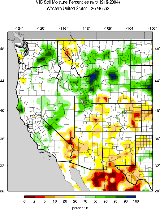
| And looking at the West. |
|

| Corn | Very Bad | Rice | Very Bad |
| Soybeans | Very Bad | Oats | Very Bad |
| Winter Wheat | Bad | Barley | Bad |
| Cotton | Bad | Spring Wheat | Very Bad |
| Sorghum | Bad | Peanuts | Good |
| Sugarbeet | OK | ||
| Sunflowers | Bad |


7. International

A map helps and is not always available but is this week

We now have the April Data for international locations. Below are selected maps. The full set can be found here.


8. Background Information


The sequence of drought occurrence and impacts for commonly accepted drought types. All droughts originate from a deficiency of precipitation or meteorological drought but other types of drought and impacts cascade from this deficiency. (Source: NDMC)
Source: National Drought Mitigation Center, University of Nebraska-Lincoln


