
Written by Sig Silber
NOAA has issued their regular Seasonal Outlook which occurs on the third Thursday of each month. It is remarkably similar to the Outlook issued last month and mainly extends the projected impact of an El Nino by one month. Japan and Australia chime in with their El Nino forecasts.

This is the Regular Edition of my weekly Weather and Climate Update Report. Additional information can be found here on Page II of the Global Economic Intersection Weather and Climate Report.
NOAA Issues Seasonal Update
The following graphic shows both June and the three-month period June – July – August. In reading this release of the Seasonal Outlook, one should pay close attention to the impacts of soil moisture which is projected to essentially create a large micro-climate for CONUS. If you like wet, it is a virtuous cycle.

This is almost identical to the prior outlook except that there is now no mention of a cold anomaly in the Great Lakes area. That possibly was mostly a May prediction and is no longer relevant. Also the similarity of the three-month forecast to the June single-month forecast is striking.
For sake of comparison, here is the JAMSTEC precipitation forecast

You can see the U.S. on this World map and the precipitation forecast for the U.S. is slightly different than the NOAA Outlook as it projects the wetter than climatology for the center of CONUS to extend further north and the Southwest Monsoon to be weaker than suggested by the NOAA Outlook. But this JAMSTEC forecast is based on an earlier May 1 computer analysis of sea surface temperatures which have become more extreme since then.
Here is the Japanese Temperature Forecast for the same period.

Again it is slightly different from the NOAA forecast mostly because the forecast for the center of CONUS being colder than climatology extends further north.
The impacts on the rest of the world are fairly extreme both with respect to precipitation and temperature especially temperature. It could be a rough time for India and Western Africa. The situation in Western Africa suggests a slow hurricane season for the U.S. East Coast.
15 Month U.S. Outlook through June – July – August 2016
Temperature
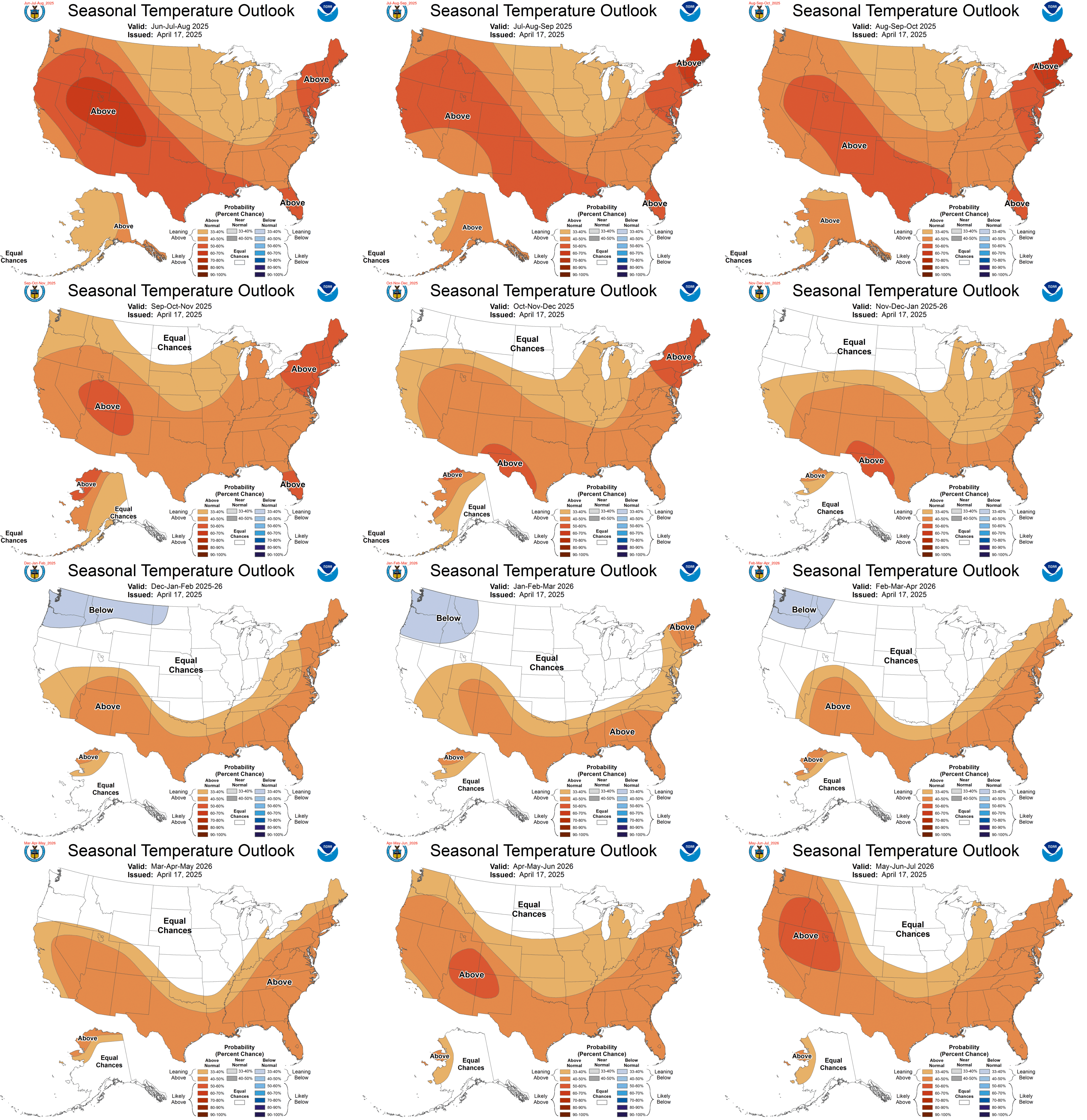
The Temperature Outlook is very similar to the Outlook issued last month except the colder than climatology areas which are probably associated with the projected El Nino extend from the Midwest down to the Southwest sooner than in the prior Outlook. Also the impacts have been extended one month and now are shown to occur through April 2016 (March – April – May 2016 Map).
Precipitation

If you want larger versions of each map (temperature and precipitation), you can find them here. And each of those maps at that link can be clicked on to further enlarge them.
Again the only change really is that the El Nino related precipitation in the New Mexico and West Texas area has been extended into April of 2016 (Mar – Apr – May) 2016. If the current El Nino forecast continues, one might expect further impacts to be reflected in the Outlook next time it is issued which will be June 18, 2015. My assessment of this Outlook is that it may not adequately take into account the PDO and AMO although it is said to do so. But the pattern shown appears to me very much determined by the assumed El Nino. There is more of a north/south divide than I think is realistic. But it still provides a pretty good idea of the pattern that is likely to apply with a lot of uncertainly about the timing of the transition and that is discussed in the NOAA discussion. Related to that is the question of whether or not there will be a late Winter negative NAO providing cool weather to the Northeast or even the Mid-Atlantic (and parts of Northern Europe) which may depend on the strength of the El Nino. NOAA is projecting a fairly strong El Nino but the three-month forecast maps presented reflect a more moderate El Nino but fairly long lasting. I think NOAA is being a bit cautious at this point and each month the Outlook will reflect greater confidence in how this winter will play out.
NOAA Discussion
I have edited the NOAA discussion in order to integrate their 30-day and long-lead discussions, reorganized some things to make it easier to follow, removed some redundancy and model-related discussions that are more of a how we prepared the forecast than what we think. But I have not changed anything that NOAA has said. You can find the full unedited discussions at here and here.
PROGNOSTIC DISCUSSION FOR SEASONAL OUTLOOKS NWS CLIMATE PREDICTION CENTER COLLEGE PARK MD 830AM EDT THURSDAY MAY 21 2015
CURRENT ATMOSPHERIC AND OCEANIC CONDITIONS
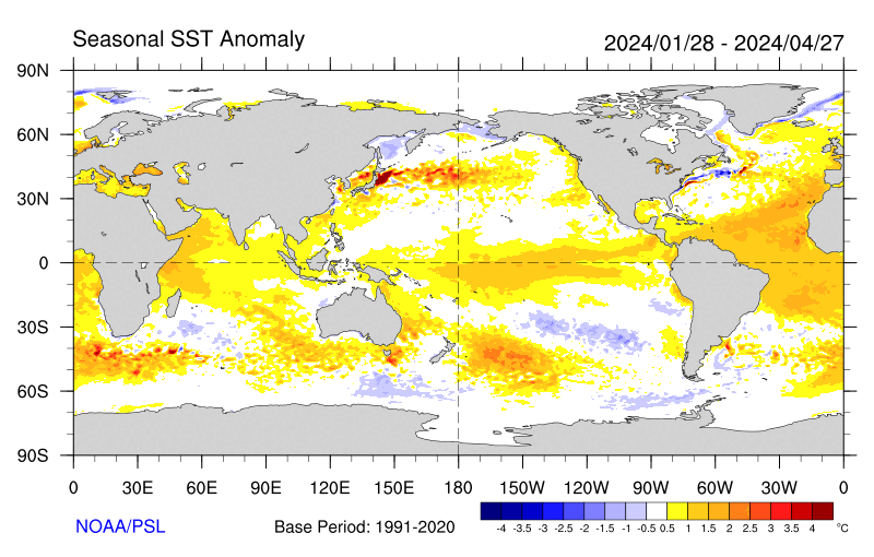
SST ANOMALIES ACROSS THE EQUATOR ARE MORE THAN +1.0 C FROM THE SOUTH AMERICAN COAST TO AROUND LONGITUDE 160 E. ANOMALIES IN EXCESS OF +2.0 C ARE OBSERVED NEAR THE SOUTH AMERICAN COAST. ANOMALIES IN THE NINO 3.4 REGION ARE CURRENTLY AROUND +1.0 C. OCEAN TEMPERATURES ALONG THE EQUATOR JUST UNDER THE SURFACE ARE CONSIDERABLY ABOVE AVERAGE, WITH ANOMALIES OF UP TO +6.0 C BETWEEN 50 AND 100 METERS DEPTH THROUGHOUT MUCH OF THE EASTERN PACIFIC. THE POSITIVE SUB-SURFACE HEAT ANOMALY PROVIDES A SOURCE OF WARMER-THAN-AVERAGE OCEAN WATER FOR CONTINUATION OF POSITIVE SST ANOMALIES FOR THE NEXT SEVERAL SEASONS. [Editor’s Note: If a “season” means three months, I do not agree with this conclusion. The impacts may last for a year but the El Nino most likely will not.]
THE ATMOSPHERIC TELECONNECTIONS TO THE SST’S CONTINUE TO BE ROBUST, WITH PERSISTENT ENHANCED CONVECTION OVER THE EQUATOR, NEAR AND TO THE EAST THE DATE LINE, AND SOME SUPPRESSED CONVECTION OVER THE FAR WESTERN EQUATORIAL PACIFIC. LOW-LEVEL WESTERLY WIND ANOMALIES AT 850 HPA HAVE BEEN CONSISTENTLY OBSERVED NEAR THE ENSO SENSITIVE REGIONS SINCE MARCH WHILE ANOMALOUS EASTERLY WINDS PERSIST AT UPPER LEVELS. THESE LARGE SCALE ATMOSPHERIC PATTERNS SUGGEST THAT EL NINO IS NOW NEAR THE BORDER LINE BETWEEN WEAK AND MODERATE STRENGTH. THE EXTRA-TROPICAL PACIFIC OCEAN REMAINS CONSISTENT WITH THE POSITIVE PHASE OF THE PDO, ALTHOUGH THE MONTHLY INDEX WEAKENED IN APRIL. THIS MAY HAVE SOME IMPACT ON CONDITIONS NEAR THE WEST COAST OF NORTH AMERICA.
PROGNOSTIC DISCUSSION OF SST FORECASTS
MOST DYNAMICAL MODELS FOR SST’S CONTINUE TO SUGGEST NINO 3.4 ANOMALIES WILL INCREASE AND PEAK THE LATE FALL. THE BIAS CORRECTED NINO 3.4 SST ANOMALIES FROM THE CFSV2 PEAKS AT JUST UNDER +2.0 C IN OND 2015. THIS AGREES WELL WITH THE CONSENSUS OF MODEL FORECASTS FOR NINO 3.4 SSTS RUN AT OTHER CENTERS, THAT ALSO SUGGEST PEAK ANOMALIES OF AROUND +2.0 C LATE IN THE YEAR. STATISTICAL FORECASTS OF NINO 3.4 ANOMALIES ARE WEAKER, BUT THE MAJORITY PREDICT ANOMALIES OF +1.0 EXTENDING THROUGH THE FALL. THE CPC CONSOLIDATION FORECAST FOR NINO 3.4 SST’S SHOWS THE ANOMALIES INCREASING TO AROUND +1.5 C BY OND AND NDJ 2015-2016, THEN DECREASING, BUT REMAINING ABOVE +1.0 C THROUGH JFM 2016. THE CPC CONSOLIDATION FORECAST PROBABILITIES FOR SST ANOMALIES STRONG ENOUGH TO PRODUCE SIGNIFICANT ATMOSPHERIC TELECONNECTIONS ARE 90% THROUGH THE SUMMER, AND REMAIN ABOVE 80% FOR THE REMAINDER OF THE YEAR. A CONSENSUS OF EXPERTS AT CPC AND IRI HAVE ISSUED SIMILAR PROBABILITIES FOR EL NINO CONDITIONS FOR THE REMAINDER OF THE YEAR. [Editor’s Note: The remainder of the year is not four seasons but two or at most three.]
June Outlook
IT MAY INTEREST THE USER THAT THE FORECAST IS ALSO CONSISTENT WITH 2-MONTH LAGGED CORRELATIONS BETWEEN THE PDO AND AMO INDICES. [Editors’ Note: This is a very important point. Sometimes we forget that there is a lag between what takes place in our oceans and that impact over land. I was not able to really convince myself that the PDO and AMO played a large role in this forecast even though part of the discussion (which I have not included) discussed how this was done. But making a forecast is not a simple formalistic procedure. There is human intervention and judgments made at many stages in the forecast process.]
THE LARGEST SIGNAL FOR BELOW-NORMAL TEMPERATURES IS CENTERED OVER NORTH TEXAS/OKLAHOMA, WHERE SOIL MOISTURE CURRENTLY EXCEEDS THE 90TH PERCENTILE AND ALL GUIDANCE IS IN AGREEMENT. LIKEWISE, THE TOOLS ARE IN GOOD AGREEMENT OVER THE PACIFIC NORTHWEST AND SOUTHERN ALASKA, WHERE THE BEST CHANCES OF ABOVE-NORMAL TEMPERATURES RESIDE. UNCERTAINTY IS LARGEST NEAR THE EAST COAST AND GREAT LAKES, WHERE EVERYTHING WAS SUBJECTIVELY COMBINED TO YIELD THE MAP AS IT STANDS.
THE ONLY SUBSTANTIAL SIGNALS FOR PRECIPITATION COME FROM UNANIMOUS DYNAMICAL AGREEMENT FAVORING ABOVE-MEDIAN RAINFALL OVER PARTS OF THE WEST-CENTRAL CONUS, EXTENDING TOWARD THE SOUTHEAST. STATISTICAL GUIDANCE IS REASONABLY ON BOARD WITH THIS, THOUGH PROBABILITIES ARE GENERALLY LOW TO REFLECT HISTORICALLY POOR FORECAST SKILL IN THE 0.5 MONTH LEAD PRECIPITATION OUTLOOK. [Editor’s Note: Here NOAA was not clear as to the lack of skill for the next month forecast being in general or only in May looking ahead to June. I assume that is what they meant.]Three Month Outlook June – July – August (JJA)
THE JUNE-JULY-AUGUST (JJA) 2015 TEMPERATURE OUTLOOK INDICATES ENHANCED PROBABILITIES OF ABOVE NORMAL TEMPERATURES FOR ALASKA, AREAS WEST OF THE ROCKY MOUNTAINS, FLORIDA AND SURROUNDING REGIONS, AND FOR NORTHERN NEW ENGLAND. CHANCES FOR BELOW-NORMAL TEMPERATURES ARE ELEVATED FROM THE FRONT RANGE OF THE CENTRAL AND SOUTHERN ROCKY MOUNTAINS EASTWARD TO NEAR THE MISSISSIPPI RIVER.
THE JJA 2015 PRECIPITATION OUTLOOK INDICATES ENHANCED CHANCES OF ABOVE-MEDIAN PRECIPITATION AMOUNTS FOR PARTS OF THE GREAT BASIN, THE ROCKY MOUNTAINS FROM SOUTHERN MONTANA SOUTHWARD, THE CENTRAL AND SOUTHERN GREAT PLAINS INCLUDING TEXAS, AND PARTS OF THE SOUTHEASTERN STATES. BELOW-MEDIAN PRECIPITATION IS FAVORED ALONG THE WEST COAST OF NORTH AMERICA FROM SOUTHEASTERN ALASKA TO COASTAL AREAS OF THE PACIFIC NORTHWEST.
15 Month Outlook JJA 2015 TO JJA 2016
TEMPERATURE
THE JJA 2015 TEMPERATURE OUTLOOK INDICATES INCREASED CHANCES FOR ABOVE NORMAL SEASONAL MEAN TEMPERATURES FOR MOST AREAS WEST OF THE ROCKY MOUNTAINS, ALL OF ALASKA, AS WELL AS PORTIONS OF THE SOUTHEAST CONUS AND IN NORTHERN NEW ENGLAND. BELOW NORMAL SEASONAL MEAN TEMPERATURES ARE FAVORED FROM THE FRONT RANGE OF THE CENTRAL AND SOUTHERN ROCKIES EASTWARD TO NEAR THE MISSISSIPPI RIVER. THE NMME, IMME, EL NINO COMPOSITES, AND FORECASTS BASED ON CONSTRUCTED ANALOGS OF BOTH GLOBAL SSTS AND SOIL MOISTURE ANOMALIES ARE IN GENERAL AGREEMENT ON THE FORECAST TEMPERATURE ANOMALY PATTERN. THERE IS DISAGREEMENT BETWEEN TOOLS IN AREAS TO THE THE EAST OF THE MISSISSIPPI RIVER, LEADING TO A FORECAST OF EQUAL CHANCES AMONG THE THREE TEMPERATURE CATEGORIES, EXCEPT FOR NORTHERN NEW ENGLAND AND PARTS OF THE SOUTHEAST WHERE ABOVE NORMAL TEMPERATURES ARE FAVORED.
TEMPERATURE ANOMALIES ARE FORECAST TO SLOWLY EVOLVE FROM THIS SUMMERTIME PATTERN TO THE WINTER TIME EL NINO PATTERN OF TEMPERATURE ANOMALIES. THE ENHANCED CHANCES OF BELOW-NORMAL TEMPERATURES SHIFTS FROM THE CENTRAL PART OF THE COUNTRY TO THE SOUTH-CENTRAL CONUS, AND THEN EXPANDS TO COVER MUCH OF THE SOUTHERN CONUS BY DJF 2015-16. THE CHANCES OF ABOVE NORMAL TEMPERATURES REMAIN ELEVATED FOR MUCH OF THE WESTERN CONUS, GRADUALLY SHIFTING NORTHWARD AND EXPANDING ALONG THE NORTHERN CONUS TO THE UPPER GREAT LAKES BY DJF. THE COOL SEASON STRENGTH OF EL NINO REMAINS UNCERTAIN AT THIS TIME SO PROBABILITY ANOMALIES ARE FAIRLY LOW. STRONGER EVENTS ARE ASSOCIATED WITH GREATER CHANCES OF ABOVE NORMAL TEMPERATURES IN THE GREAT LAKES REGION. EL NINO CONDITIONS GENERALLY FAVOR ABOVE NORMAL TEMPERATURES FOR MUCH OF ALASKA THROUGH THE FALL AND WINTER, AND THE FORECASTS FROM THE NMME AND IMME SUGGEST GREATER CONFIDENCE IN ABOVE NORMAL TEMPERATURES THAN WOULD BE EXPECTED ON THE BASIS OF EL NINO ALONE. PROBABILITIES FOR ABOVE NORMAL TEMPERATURES ARE PARTICULARLY ELEVATED FOR NORTHERN ALASKA WHERE THE EXPECTED ANOMALOUSLY LOW ARCTIC OCEAN ICE COVER MAY HELP RAISE TEMPERATURES IN NEARBY AREAS.
THE FORECASTS INDICATE THAT SSTS IN THE NINO 3.4 REGION MAY REMAIN ELEVATED INTO LATE WINTER, SO EL NINO IMPACTS WILL LIKELY EXTEND INTO THE LATE WINTER BEFORE LIKELY ENDING BY THE SPRING OF 2016. THE OUTLOOKS FOR AMJ AND MJJ 2016 SHOW A TRANSITION OF TEMPERATURES ASSOCIATED WITH EL NINO TO ANOMALIES SUGGESTED BY THE LONG TERM TRENDS. TYPICALLY ANOMALOUS SOIL MOISTURE CONDITIONS RESULTING FROM THE WINTERTIME EL NINO IMPACTS CAN RESULT IN LOCALIZED CLIMATE ANOMALIES PERSISTING INTO THE LATE SPRINGTIME IN SOME AREAS. THE OUTLOOK FOR JJA 2016 WAS BASED PRIMARILY ON THE STATISTICAL TOOLS AND TRENDS AS REFLECTED IN THE CPC CONSOLIDATION FORECAST.
PRECIPITATION
THERE IS GOOD AGREEMENT AMONG THE NMME, IMME, EL NINO COMPOSITES AND CONSTRUCTED ANALOGS BASED BOTH ON SSTS AND CURRENT SOIL MOISTURE CONDITIONS FOR ENHANCED CHANCES OF ABOVE MEDIAN PRECIPITATION AMOUNTS OVER MUCH OF THE CONUS, EXTENDING FROM THE INTERMOUNTAIN WEST TO THE CENTRAL AND SOUTHERN GREAT PLAINS, AND SOUTHEASTWARD TO INCLUDE THE SOUTHEASTERN STATES. THE NMME AND IMME SUGGEST THAT THE CHANCES OF BELOW-MEDIAN PRECIPITATION AMOUNTS ARE ELEVATED ALONG THE PACIFIC COAST FROM THE PACIFIC NORTHWEST TO THE ALASKAN PANHANDLE. THE FORECAST FROM THE NMME IS WETTER THAN EL NINO COMPOSITES WOULD SUGGEST. THIS IS PARTICULARLY TRUE IN INTERIOR ALASKA, THE GREAT LAKES, AND THE WESTERN PORTIONS OF THE SOUTHWESTERN MONSOON REGION, WHERE EL NINO COMPOSITES FAVOR DRY CONDITIONS, WHILE THE NMME FAVORS WET. THESE AREAS ARE MARKED AS EQUAL CHANCES FOR ABOVE- NEAR- OR BELOW MEDIAN PRECIPITATION AMOUNTS IN VIEW OF THE CONFLICTING INDICATIONS. [Editor’s Note: We might expect some clarification in next month’s Seasonal Outlook.]
THE SIGNAL FOR ABOVE-MEDIAN PRECIPITATION OVER THE CENTRAL CONUS DIMINISHES WITH TIME, SHIFTING TO THE SOUTHERN ROCKIES AND THE SOUTHWESTERN CONUS IN THE FALL. EL NINO IMPACTS TENDS TO ELEVATE THE CHANCES OF TROPICAL MOISTURE FROM THE EASTERN PACIFIC INFLUENCING NORMALLY DRY REGIONS OF THE SOUTHWEST IN THE FALL, FAVORING ABOVE MEDIAN PRECIPITATION AMOUNTS IN THE SOUTHWEST EXTENDING TO THE SOUTHERN CALIFORNIA COAST IN ASO AND SON 2015. THE NMME FORECASTS APPEARS TOO WET THROUGH ALL LEAD TIMES AND HAVE BEEN REVISED DOWNWARD TOWARD MORE TYPICAL EL NINO IMPACTS. HOWEVER IT SHOULD BE NOTED THAT THE NMME FORECASTS FROM EARLIER IN THE SPRING APPEAR ON TARGET BASED ON RECENT PRECIPITATION OBSERVATIONS OVER MUCH OF THE ROCKY MOUNTAINS AND GREAT PLAINS. THERE ARE SOME HINTS THAT THE CHANCES FOR BELOW MEDIAN PRECIPITATION ARE ELEVATED NEAR PARTS OF THE MID-ATLANTIC STATES IN THE LATE SUMMER, SUPPORTED WEAKLY BY THE CFSV2 IN JAS 2016. ONE OF THE FEW PLACES WHERE THE NMME FAVORS DRY CONDITIONS OVER THE CONUS IS NEAR THE PACIFIC NORTHWEST, SUGGESTING THAT ELEVATED CHANCES FOR BELOW MEDIAN PRECIPITATION AMOUNTS EXPECTED IN JJA WILL PERSIST INTO THE FALL AND EARLY WINTER. EL NINO COMPOSITES SUGGEST WET CONDITIONS IN THE FALL AND EARLY WINTER ALONG THE SOUTH COAST OF ALASKA WITH SOME SUPPORT FROM THE NMME AND IMME.
EL NINO CONDITIONS ARE EXPECTED TO CONTINUE WITH SUFFICIENT STRENGTH INTO THE WINTERTIME TO PRODUCE ITS TYPICAL PRECIPITATION IMPACTS. THUS THE CHANCES FOR ABOVE-MEDIAN PRECIPITATION ARE ELEVATED THROUGHOUT THE SOUTHERN CONUS FROM OND 2015 – JFM 2016. INCREASED CHANCES OF BELOW MEDIAN PRECIPITATION AMOUNTS ARE EXPECTED FOR THE NORTHERN ROCKIES AND PARTS OF THE INTERIOR EAST NORTH-CENTRAL CONUS FROM DJF – FMA 2015-16. WINTER IS STILL A LONG WAY OFF, MAKING THE STRENGTH OF THIS THE EL NINO SOMEWHAT UNCERTAIN AT THIS TIME, SO PROBABILITY ANOMALIES ARE QUITE LOW ON THIS SERIES OF WINTERTIME OUTLOOKS. IF THE SUBSEQUENT EVOLUTION OF EL NINO STAYS ON TRACK, CONFIDENCE WILL INCREASE CONSIDERABLY AS WINTER APPROACHES.[Editor’s Note: I will discuss how the Spring Prediction Barrier(SPB) impacts forecast reliability in the El Nino Update Section of this week’s report]
WITH THE STRENGTH AND CERTAINTY OF EL NINO CONDITIONS DIMINISHING IN THE EARLY PART OF 2016, THE RELIABLE SIGNALS FOR PRECIPITATION ANOMALIES VANISH BY AMJ 2016, LEADING TO EQUAL CHANCES FOR ABOVE- NEAR- AND BELOW MEDIAN PRECIPITATION AMOUNTS THROUGHOUT THE FORECAST DOMAIN FOR AMJ 2016 AND BEYOND. THE OUTLOOK FOR MAM 2016 WAS REVISED FROM THE THE ONE RELEASED LAST MONTH TO REFLECT THE INCREASING CONFIDENCE THAT EL NINO CONDITIONS WILL PERSIST LONG ENOUGH IN THE WINTER TO IMPACT SPRINGTIME SOIL MOISTURE CONDITIONS. ELEVATED SOIL MOISTURE CONDITIONS RESULTING FROM EXPECTED ABOVE NORMAL PRECIPITATION NEAR WEST TEXAS AND EASTERN NEW MEXICO ARE EXPECTED TO HELP ELEVATE THE CHANCES OF ABOVE-MEDIAN PRECIPITATION AMOUNTS IN PARTS OF TEXAS AND THE SOUTHERN ROCKIES IN MAM 2016.
I will now shift timeframes dramatically.
Current (Now to 5 Days) Weather Situation:
For daily forecasts it is better to consult your local weather service or the weather service where you are traveling as these will be more specific. But I do have daily forecasts on Page II of the Report so you can always look at those as they auto-update. What I present here is information that normally is not made available via local weather forecasts and which can help you understand what some of the major drivers are for the local forecast.
First here is a national 12 hour to 60 hour forecast of weather fronts shown as an animation. Beyond 60 hours, the maps are available in Part II of the Global Economic Intersection Weather and Climate Report.

The explanation for the coding used in these maps i.e. the full legend can be found here.
Sometimes it is useful to take a look at the location of the Jet Stream or Jet Streams. This and the following graphic update every six hours. The continuation of the split jet stream may be related to the Warm Event.

And sometimes the forecast is revealing. Below is the forecast out five days. The Jet Stream especially the southern branch may be starting to be less intense and you can read the wind speed expressed in knots per hour off of this graphic.

To see it in animation, click here.
This longer animation shows how the jet stream is crossing the Pacific. Up until this week I have been saying that “one can imagine that attempting to forecast this 6 – 14 days out is quite challenging and NOAA is having fits attempting to guess how this will play out over a 14 day period especially for the Southwest“. Recently I viewed the animation and you can see that now the jet stream is really falling apart half-way over the Pacific which is what one would expect this time of year i.e. it is having less of an impact.
And below is another view which highlights the surface highs and the lows re air pressure on Day 3. The Aleutian Low is still active and probably is the most obvious indication of this Warm Event and has kept Alaska warmer and wetter than usual all winter. It has now shifted position more to the west off of Kamchatka Russia (which at one point the U.S. almost acquired). In this position, the Aleutian Low still impacts Alaska but has less of an impact on CONUS. The RRR which normally is not active in an El Nino year but is active in an El Nino Modoki Type II year is still in the picture but is a shadow of its former self (i.e. no tightly wound isobars). Although in this graphic right now (and remember these graphics auto update), the RRR has moved north filling in the gap created by the Aleutian Low moving to the west so it is impacting weather but further north than recently.

And here is Day 6 which as I am looking at it shows quite a bit of change which I suspect is making short and mid-term forecasts challenging. .

Outlook Days 6 – 14 (but only showing the 8 – 14 Day Maps)
Here is the updated Temperature Outlook for June which was issued on May 21.

And here is the 8 – 14 Day Temperature Outlook issued today May 25, 2015. It covers the week following the coming week.

Remember that the 6 – 14 day outlook only covers 9 days not the full month and the map shown only covers seven days. This Outlook (which applies not to this coming week but the following week) is far more intense than the Monthly Outlook for June issued on May 21 which is just four days ago.
Here is the updated Precipitation probabilities for June issued on May 21, 2015.

Here is the 8 – 14 Day Precipitation Outlook issued today May 25, 2015.

And again remember that this map shows only seven days and the full 6 – 14 Day Outlook only covers nine days. There are 31 days in June. But the week following this coming week (Days 8 -14 of the NOAA Outlook) is projected to be drier in Alaska and along the Northwest Coast of CONUS than shown in the newly issued June Outlook. Also, and importantly, the precipitation expected for the the Plains States has been reduced while the precipitation expected for the Northern Tier and Northeast is greater than what was forecast for the full month of June. Over the weekend, the unsupervised computers actually flirted with showing the Plains States and Denver in particular being flipped from wetter than climatology to drier than climatology. Today you see what might be considered a compromise between the computers and the meteorologists. We shall see how this works out.
Here are excerpts from the very interesting and informative NOAA release today May 25, 2015.
6-10 DAY OUTLOOK FOR MAY 31 – JUN 04, 2015
TODAY’S MODEL SOLUTIONS ARE IN FAIRLY GOOD AGREEMENT ON THE 500-HPA CIRCULATION PATTERN OVER NORTH AMERICA AND VICINITY. A TROUGH IS PREDICTED OVER THE WESTERN ALEUTIANS AND A RIDGE IS FORECAST DOWNSTREAM OVER MUCH OF THE REMAINDER OF ALASKA. FARTHER TO THE SOUTH, A BROAD, LOW AMPLITUDE TROUGH IS PREDICTED OVER THE PACIFIC AND A WEAK TROUGH IS FORECAST NEAR THE MISSISSIPPI VALLEY. RELATIVELY LOW AMPLITUDE FLOW IS PREDICTED BY MOST MODEL SOLUTIONS ACROSS THE CONUS. AS A RESULT, NEAR TO ABOVE NORMAL HEIGHTS ARE FORECAST OVER MUCH OF THE COUNTRY. TODAY’S 500-HPA BLEND CHART IS WEIGHTED MOST HEAVILY ON THE ECMWF AND CANADIAN ENSEMBLE MEANS AND BASED PRIMARILY ON CONSIDERATIONS OF RECENT SKILL AND ON ANALOG CORRELATIONS, WHICH MEASURE HOW CLOSELY THE FORECAST PATTERN MATCHES CASES THAT HAVE OCCURRED IN THE PAST.
ABOVE NORMAL TEMPERATURES ARE FAVORED FOR MUCH OF ALASKA DUE TO PREDICTED RIDGING. ENHANCED PROBABILITIES OF ABOVE NORMAL TEMPERATURES ARE ALSO INDICATED FOR MUCH OF THE WESTERN CONUS CONSISTENT WITH BIAS CORRECTED TEMPERATURES FROM THE ECMWF ENSEMBLES AND GEFS REFORECAST GUIDANCE. BELOW NORMAL TEMPERATURES ARE FAVORED FOR MUCH OF THE SOUTHERN PLAINS AND PARTS OF THE CENTRAL PLAINS IN ASSOCIATION WITH A TROUGH PREDICTED NEAR THE MISSISSIPPI VALLEY AND ALSO DUE TO SOIL MOISTURE CONSIDERATIONS. THERE ARE ENHANCED PROBABILITIES OF ABOVE NORMAL TEMPERATURES FOR MUCH OF THE EASTERN QUARTER OF THE CONUS AHEAD OF THE PREDICTED MEAN TROUGH AXIS.
PROBABILITIES FOR ABOVE MEDIAN PRECIPITATION ARE ENHANCED FOR MUCH OF THE EASTERN CONUS AND SOUTHERN PLAINS IN ASSOCIATION WITH A MEAN TROUGH PREDICTED NEAR THE MISSISSIPPI VALLEY. NEAR TO BELOW MEDIAN PRECIPITATION IS FAVORED BEHIND THE TROUGH AXIS FOR MUCH OF THE CENTRAL PLAINS AND CENTRAL AND SOUTHERN ROCKIES. ABOVE MEDIAN PRECIPITATION IS FAVORED FOR THE NORTHERN INTERMOUNTAIN WEST, NORTHERN ROCKIES, AND PARTS OF THE NORTHERN PLAINS CONSISTENT WITH PRECIPITATION ESTIMATES FROM THE GFS AND ECMWF ENSEMBLE MEMBERS. CONVERSELY, BELOW MEDIAN PRECIPITATION IS FAVORED FOR MUCH OF ALASKA DUE TO PREDICTED RIDGING.
FORECAST CONFIDENCE FOR THE 6-10 DAY PERIOD: ABOVE AVERAGE, 4 OUT OF 5, DUE TO FAIRLY GOOD AGREEMENT AMONG THE VARIOUS MODELS AND SURFACE TOOLS.
8-14 DAY OUTLOOK FOR JUN 02 – 08 2015
DURING THE WEEK TWO PERIOD, TODAY’S ENSEMBLE MEAN SOLUTIONS ARE SIMILAR TO THAT PREDICTED DURING THE 6 TO 10 DAY PERIOD. RIDGING AND ABOVE NORMAL HEIGHTS ARE FORECAST FOR MUCH OF ALASKA. MOSTLY ZONAL FLOW AND ABOVE NORMAL HEIGHTS ARE FORECAST ACROSS MUCH OF THE NORTHERN HALF OF THE CONUS WHILE NEAR NORMAL HEIGHTS ARE PREDICTED OVER MUCH OF THE SOUTHERN TIER OF THE CONUS. ENSEMBLE SPREAD IS MODERATELY HIGH OVER MUCH OF THE FORECAST DOMAIN INDICATING MODEL DIFFERENCES IN RESOLVING INDIVIDUAL SHORTWAVE FEATURES WITHIN THE OVERALL FLOW PATTERN. TODAY’S WEEK TWO MANUAL 500-HPA HEIGHT BLEND IS BASED PRIMARILY ON THE ENSEMBLE MEAN SOLUTIONS WITH THE GREATEST WEIGHTS GIVEN TO TODAY’S 0Z ECMWF AND 0Z CANADIAN ENSEMBLE MEANS.
ABOVE NORMAL TEMPERATURES ARE FAVORED FOR MUCH OF THE CONUS IN ASSOCIATION WITH FORECAST LOW AMPLITUDE FLOW AND PREDICTED NEAR TO ABOVE NORMAL HEIGHTS. HOWEVER, THERE ARE ENHANCED PROBABILITIES OF BELOW NORMAL TEMPERATURES FOR PARTS OF THE SOUTHERN PLAINS DUE, IN PART, TO SOIL MOISTURE CONSIDERATIONS. ABOVE NORMAL TEMPERATURES ARE FAVORED FOR MOST OF ALASKA IN ASSOCIATION WITH PREDICTED RIDGING.
ABOVE MEDIAN PRECIPITATION IS FAVORED FOR MUCH OF THE EASTERN CONUS CONSISTENT WITH GEFS REFORECAST GUIDANCE. HOWEVER ENHANCED PROBABILITIES OF ABOVE MEDIAN PRECIPITATION ARE WEAK ACROSS MUCH OF THE REGION DUE TO CONFLICTING GUIDANCE FROM THE ECMWF ENSEMBLES, WHICH PREDICT A RELATIVELY DRIER PATTERN. NEAR TO BELOW MEDIAN PRECIPITATION IS FAVORED FOR MOST OF ALASKA IN ASSOCIATION WITH PREDICTED RIDGING. NEAR TO BELOW MEDIAN PRECIPITATION IS ALSO FAVORED FOR MUCH OF THE WESTERN QUARTER OF THE CONUS CONSISTENT WITH GEFS REFORECAST GUIDANCE.
FORECAST CONFIDENCE FOR THE 8-14 DAY PERIOD IS: AVERAGE, 3 OUT OF 5, DUE TO FAIRLY GOOD AGREEMENT AMONG THE ENSEMBLE MEAN SOLUTIONS OFFSET BY DISAGREEMENTS AMONG THE SURFACE TOOLS (PARTICULARLY FOR PRECIPITATION).“ [Editor’s Note: there was as mentioned earlier, another dust up between the unsupervised computers and the human meteorologists this weekend and of course the humans have the final say but it is clear that there is some significant disagreement that had to be resolved re the 8-14 Day Portion of today’s Outlook. I do not believe it is correct to say that the disagreement is simply about precipitation. When I look at the unedited maps issued over the weekend and the edited maps issued today, it looks like both temperature and precipitation are involved and they are intertwined.]
Analogs to Current Conditions
Now let us take a detailed look at the “Analogs” which NOAA provides related to the 5 day period centered on 3 days ago and the 7 day period centered on 4 days ago. “Analog” means that the weather pattern then resembles the recent weather pattern and was used in some way to predict the 6 – 14 day Outlook.
Here are today’s analogs in chronological order although this information is also available with the analog dates listed by the level of correlation. I find the chronological order easier for me to work with. There is a second set of analogs associated with the outlook but I have not been analyzing this second set of information. This first set applies to the 5 and 7 day observed pattern prior to today. The second set which I am not using relates to the forecast outlook 6 – 10 days out to similar patterns that have occurred in the past during the dates covered by the 6 – 10 Day Outlook. That may also be useful information but they put this set of analogs in the discussion with the other set available by a link so I am assuming that this set of analogs is the most meaningful.
Analog Centered Day | ENSO Phase | PDO | AMO | Other Comments |
| 1969 June 8 | El Nino | – | Neutral | Modoki Type II |
| 1971 June 4 | La Nina | – | – | |
| 1971 June 5 | La Nina | – | – | |
| 1989 June 2 | La Nina | Neutral | – | Tail end |
| 1989 June 3 | La Nina | Neutral | – | Tail end |
| 1990 May 6 | Neutral | Neutral | – | |
| 1990 May 7 | Neutral | Neutral | – | |
| 2003 June 7 | Neutral | + | + | |
| 2008 May 26 | La Nina | – | + |
The most striking aspect of these analogs is the June dates given that these analogs represent conditions that were either three or five days earlier than today which is May 25. So we seem to have jumped ahead into Mid-June weather with respect to these Outlooks. The single El Nino analog combined with five La Nina analogs makes one wonder where the current declared El Nino went. It does not seem to be a factor in the 6 -14 Day Outlook. The ocean phases of the analogs correspond most closely with McCabe Condition B. You can see Condition B on the maps shown below. The seminal work on the impact of the PDO and AMO on U.S. climate can be found here. It has seemed to me for some time now that it is the Atlantic not the Pacific that is controlling U.S. weather and these analogs confirm that.

You may have to squint but the drought probabilities are shown on the map and also indicated by the color coding with shades of red indicating higher than 25% of the years are drought years (25% or less of average precipitation for that area) and shades of blue indicating less than 25% of the years are drought years. Thus drought is defined as the condition that occurs 25% of the time and this ties in nicely with each of the four pairs of two phases of the AMO and PDO.
Progress of the Warm Event
There was no ENSO report from NOAA today so I am going to wing it with alternate sources of information. That is always interesting.
Here are the low-level wind anomalies

It is marked as being up to date as of May 22. As you can see that major wind gust is over and another way of looking at things is the SOI Index which is related. Here I have more up-to-date information.
Below is the Southern Oscillation Index (SOI) reported by Queensland. The first column is the tentative daily reading, the second is the 30 day running average and the third is the 90 day average.
19 May 2015 -23.5 -16.02 -9.19
20 May 2015 -3.1 -16.18 -9.41
21 May 2015 -6.6 -16.05 -9.75
22 May 2015 -12.4 -16.09 -10.16
23 May 2015 -17.70 -16.49 -10.48
24 May 2015 -3.10 -16.8 -10.41
25 May 2015 +5.6 -16.95 -10.20
This past week the SOI has been far less intense than recently. It started being extremely intense about two weeks ago but this week has barely been consistent with El Nino. Usually -8 is considered El Nino Conditions. Sometimes -6 is used for local forecasting in Australia. The 30 average, which is the most widely used measure, on May 25 was reported as being -16.95 which is definitely in El Nino territory but not much changed from the prior week. The 90 day average is also now in El Nino territory.
Let us now take a look at the progress of the Kevin wave which is the key to the situation. This animation shows the progress of the current Kelvin Wave.

I hope the animation goes beyond May 18 when you get to view it but it is clear that this Kelvin Wave is progressing and will exit stage right fairly soon.
Necessity is the mother of invention and I realize I can post this graphic AND IT WILL AUTO UPDATE SO BY THE TIME YOU READ IT IT PROBABLY WILL BE UP TO DATE AS OF MAY 25. How cool is that!

The bottom half of the graphic is not too useful as it simply shows the thermocline between warm and cool water which pretty much always looks like as shown there but with the cooler blue water making it to the surface in the Eastern Pacific. The upper graphic shows the anomalies and although NOAA does not want to recognize a potential upwelling wave in the Western Pacific, it shows on this graphic. The key to the equation here is will there be a follow-up downwelling wave and so far it is not showing up. That is why I am skeptical about all of the ENSO model projections that show this El Nino continuing beyond July of this year. It is clear that the impacts on Ecuador and Peru will last two months longer than anywhere else.
Here are the surface anomalies.

It is up to date. I do not know if it auto-updates. The graphic may, but the date shown will not update. It is interesting to me that the warm anomalies off the West Coast are not uniformly distributed.
What I am missing, that the NOAA weekly report provides, is the change in the anomalies over recent weeks. I am not sure where they get that. But in lieu of that, I will provide the three-month average.
And you can see the change especially along the Equator in the Pacific. Notice that a daily picture shows more detail than when you have three months of daily pictures averaged.
For my own amusement, I thought I would recalculate the ONI again as I have been doing recently. The little tick marks on the chart can be used instead of a ruler. When I print out this graphic, one tick is about one centimeter. So you can use a ruler or just estimate the number (including fractions) of tick marks.

So as of Monday May 25 in the afternoon working from the May 24 TAO/TRITON report, this is what I calculated.
| Anomaly Segment | Midpoint | Length on Equator in number of five degrees of latitude (ticks) | Midpoint X Length (tempxticks) |
| -0.5C to 0C | -0.25 | 0 | 0 |
| 0C to +0.5C | +0.25 | 0 | 0 |
| +0.5C to 1.0C | +0.75 | 0 | 0 |
| 1.0C to 1.5C | +1.25 | 5 | 6.25 |
| 1.5C to 2.0C | +1.75 | 0 | 0 |
| 1.75 | Total | 5 Ticks (or 5 centimeters) | 6.25 |
| Estimated ONI the NINO 3.4 Anomaly | 6.25/5 = 1.25 C |
My estimate of the Nino 3.4 ONI is now 1.25 which is a very respectable value and essentially the same as week. Overall it looks to me like this warm event may have reached its peak intensity.
I do not have the report from NOAA, so I will use the recent report from Australia.

That looks like an ONI of just under 1.2. Here is the discussion that goes with the model results:.
El Niño strengthens
Issued on 26 May 2015
The El Niño in the tropical Pacific continues to strengthen. International climate models surveyed by the Bureau indicate sea surface temperatures will remain well above El Niño thresholds at least into the southern hemisphere spring. [Editor’s Note: That means northern hemisphere fall.]
Oceanic and atmospheric indictors show a clear El Niño signal. Sea surface temperatures in the tropical Pacific Ocean have exceeded El Niño thresholds for nearly two months, supported by warmer-than-average waters below the surface. Trade winds have remained consistently weaker than average since the start of the year, cloudiness at the Date Line has increased, and the 90-day average Southern Oscillation Index (SOI) is now below −10.
El Niño is often associated with below-average winter and spring rainfall over eastern Australia, and above-average daytime temperatures over the southern half of the country. However, the strength of El Niño doesn’t directly relate to the strength of its effects on Australia’s climate.
The Indian Ocean Dipole (IOD) is currently neutral, with the majority of the Indian Ocean being warmer that average. Of the five international models that monitor the IOD, three suggest a positive IOD event is likely later in 2015. A positive IOD is typically associated with reduced winter and spring rainfall over parts of southern and central Australia.
The key question really is the issue of the inventory of warm water in the Pacific Ocean Warm Pool; both the surface and subsurface down to 300 meters. The Faux El Nino this past winter did dissipate heat from the ocean into the atmosphere. Is there enough heat left to sustain this Warm Event? I suspect not but we will see.
All predictions about El Nino for next winter must be tempered by what is called the Spring Prediction Barrier (SPB). Nevertheless, El Nino conditions impacting the first half of this coming winter are very likely but the intensity of the El Nino conditions remains to me an open question. Since we are already in May, the SPB relates to the JAS prediction of the intensity of the El Nino during this period of time. Based on the available data, the SPB may not impact the OND forecast very much but may again come into play relative to the JFM forecast. So the duration of this Warm Event also for me remains an open question. The errors are usually over prediction of intensity rather than under prediction.
Greater than single-winter warm events are fairly rare. I looked at the NOAA list of El Ninos declared since 1950 and there are 19 of them and only two lasted through two winters. One started at the time of year that this Warm Event first reached a ONI 0.5 level and one started later in the season. Both were during a period later recognized as PDO+. So I am just wondering if there is a reason to assume that this particular Warm Event has the staying power of the former champions. The PDO is currently positive but not as positive as recently and what has occurred so far re this Modoki Type II in terms of geographical coverage of warmer water has been minimal so the dissipating impacting may have been sufficiently minimal to allow this event to make it through this winter. I will be surprised if that happens but I have been surprised before.
The Japanese view of ENSO.

Here is the latest commentary from Japan:
May 21, 2015
Prediction from 1st May, 2015
ENSO forecast: The SINTEX-F model predicts a strong El Niño to develop in the tropical Pacific in a couple of months; it may reach a maximum in boreal fall and winter. The SST observation shows a signature of rapid developing warm SST anomalies in the central-eastern equatorial Pacific extending to the South American coast, which may lead to a coupled mode evolution.
Indian Ocean forecast: The basin-wide warming SST pattern presently observed in the Indian Ocean is expected to change into a positive Indian Ocean Dipole (IOD) event in late boreal summer and fall. This evolution is rather late compared to the canonical IOD and we expect El Niño influences may be more prominent in coming boreal summer.
Regional forecast: In boreal summer, as a seasonally averaged view, most parts of Europe, Africa, Western Russia, India, Southeast Asia, South America, Canada, and Far East will experience a warmer-than-normal condition. On the other hand, Southern Australia, central U.S., eastern Russia will experience a colder-than-normal condition. Based on monthly pictures (not shown), Japan will be in a warmer-than-normal condition in June, but after that we expect a cooler-than-normal condition in July-August. It may be related to expected immature Bonin high due to El Niño development in the tropical Pacific.
The seasonally averaged rainfall forecast for boreal summer shows that most parts of Western Africa and India would experience a drier-than-normal condition. On the other hand, most parts of Southeast Asia and Japan (except for northern Japan) will experience a wetter-than-normal condition. The monthly forecast outputs suggest more rain in southern Japan particularly in June-July. All those may be partly related to the El Niño development in the tropical Pacific, too.
As you can see Japan is now forecasting a powerful El Nino but one that starts to weaken in January. Notice the mention of a Bonin High. This article might explain it. From the Summary.
SUMMARY
The Bonin high is a subtropical anticyclone that is predominant near Japan in the summer. This anticyclone is associated with an equivalent-barotropic structure, often extending throughout the entire troposphere. Although the equivalent-barotropic structure of The bonin high has been known for years among synopticians because of its importance to the summer climate in east Asia, there are few dynamical explanations for such a structure. The present paper attempts to provide a formation mechanism for the deep ridge near Japan. We propose a new hypothesis that this equivalent-barotropic ridge near Japan is formed as a result of the propagation of stationary Rossby waves along the Asian jet in the upper troposphere (‘the Silk Road pattern’). First, the monthly mean climatology is examined in order to demonstrate this hypothesis. It is shown that the enhanced Asian jet in August is favourable for the propagation of stationary Rossby waves and that the regions of descent over the Eastern Mediterranean Sea and The Aral Sea act as two major wave sources. Second, a primitive-equation model is used to simulate the climatology of August. The model successfully simulates the Bonin high with an equivalent-barotropic structure. The upper-tropospheric ridge is found to be enhanced by a height anomaly of more than 80 m at 200 hPa, when a wave packet arrives. Sensitivity experiments are conducted to show that the removal of the diabatic cooling over the Asian jet suppresses the Silk Road pattern and formation of an equivalent-barotropic Ridge near Japan, while the removal of the diabatic heating in the western Pacific does not.” [Editor’s Note: This is another of the atmospheric features that determine climate although this feature may not be as robust as some others and is mainly a factor during the summer.]
Pulling it All Together.
We are in El Nino conditions now. The length and intensity of this El Nino is still not clear mostly in terms of whether or not it will extend into the early part of 2016. We may or may not have a Pacific Climate Shift as the PDO+ may be simply related to the Warm Event (and quite frankly at this point appears to be). But for now we do have PDO+. The AMO being an overturning may be more predictable so the Neutral status moving towards AMO- is probably fairly reliable but not necessarily proceeding in a straight line. So none of this is very difficult to figure out actually if you are looking at say a five-year forecast.The research on Ocean Cycles is fairly conclusive and widely available to those who seek it out. I provided a lot of information on this in prior weeks and all of that information is preserved in Part II of my report which you can get to below. It includes decade by decade predictions through 2050. Predicting a particular year is far harder. My Editor tells me that he will show me how to create a Table of Contents for Part II to make it easier to navigate.
Click Here for the Econointersect Weather and Climate Page II where you will find:
- A more complete set of NOAA and other agency graphics (including international agencies) that auto update. So this includes both short term- and seasonal “updates”. Most of the graphics will ALWAYS be up to date even if my commentary on the graphics is not. I update my commentary when it seems necessary and certainly every Monday, but some of these graphics auto update every six hours.
- Economic and other Impacts of major weather events. Not sure there is any other place to obtain this information consistently other than very specialized subscription services.
- Information on Climate Cycles both those which are fairly short term i.e. less than a decade in duration and multi-decadal cycles.
- Economic and other Impacts of those Climate Cycles which are referred to by the IPCC as Internal Variability as opposed to secular Climate Change which is always in the same direction. Again I am not sure if there is another source for this information where it is pulled together in one place as I have.
Click Here for Page III which deals with Global Warming.
- Information on Anthropogenic Global Warming science i.e. the secular change in our climate that overlays both short-term weather and historical climate cycles as well as black swan events like volcanic eruptions. I prefer to call this Global Warming as it is the warming that triggers the other changes.
- Economic and other Impacts of Global Warming. The IPCC AR5 WG2 attempts to describe and quantify these and I have some excerpts from their report. Over time I will go beyond their report as it is very deficient.


